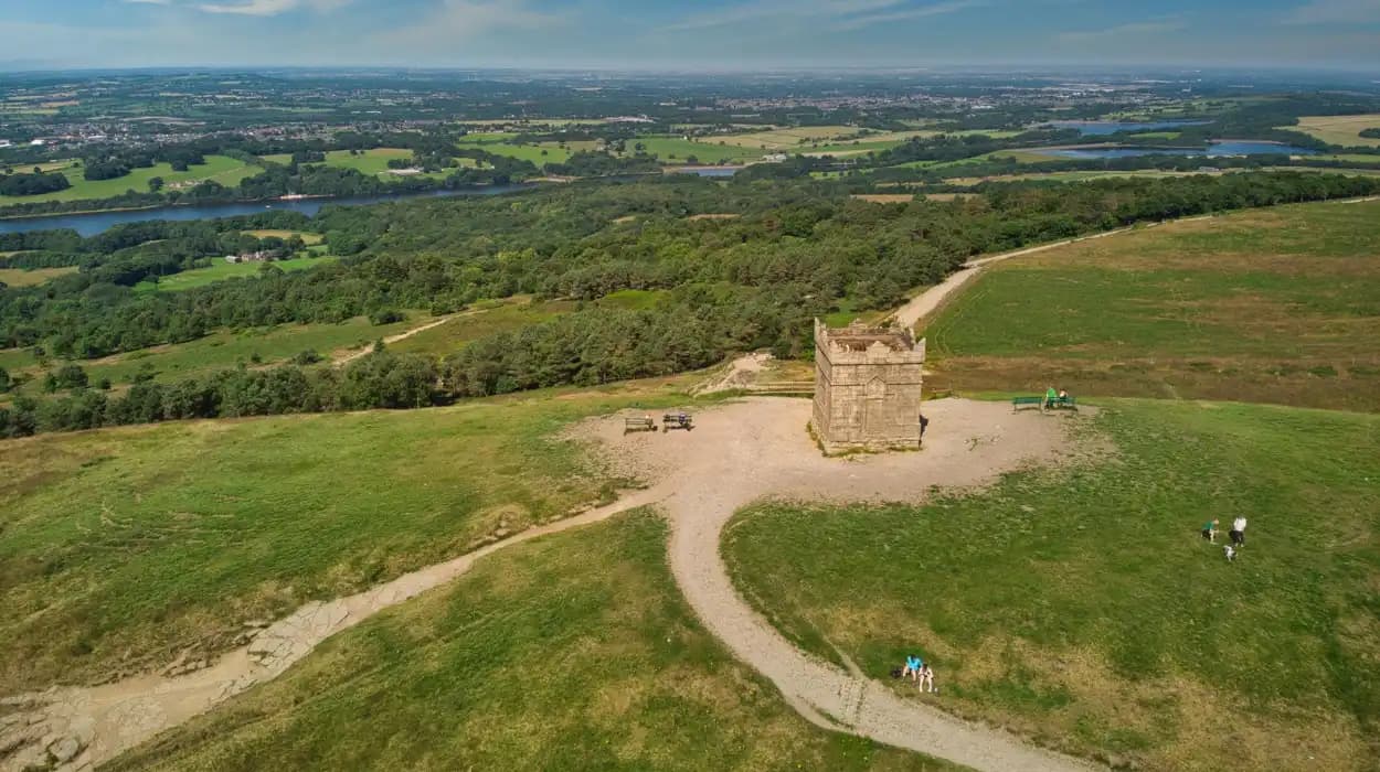
Bolton's hills, viewpoints, and scenic landscapes define the physical character of the borough and have shaped its history for thousands of years. Rising above the industrial valleys of Greater Manchester, these upland areas provided early settlers with defensible locations, supplied water for agriculture and industry, influenced transport routes, and later became places of recreation, conservation, and heritage appreciation.
Today, Bolton's surrounding moorlands, reservoirs, country parks, and panoramic summits attract walkers, photographers, historians, and nature enthusiasts. However, these landscapes are far more than attractive scenery. They preserve evidence of prehistoric communities, medieval farming, the Industrial Revolution, Victorian engineering, military history, and modern environmental conservation.
The hills surrounding Bolton—including Winter Hill, Rivington Pike, Turton Heights, Smithills Moor, and the West Pennine Moors—represent thousands of years of continuous interaction between people and landscape. Their archaeological remains, historic tracks, reservoirs, and protected habitats provide one of north-west England's richest cultural landscapes.
Why are Bolton's hills and scenic landscapes historically important?
Bolton's hills and scenic landscapes preserve over 6,000 years of human activity, from prehistoric settlements and Bronze Age monuments to medieval farming, industrial water systems, Victorian recreation, and modern conservation. They illustrate how geography shaped settlement, transport, industry, defence, and community identity across Greater Manchester.
The elevated landscape surrounding Bolton formed long before human settlement. During the last Ice Age, glaciers carved valleys, exposed gritstone ridges, and created peat-covered uplands that still dominate the western Pennines.
As the glaciers retreated around 12,000 years ago, vegetation gradually colonised the landscape. Forests covered lower slopes, while open moorland developed across higher elevations where shallow soils and harsh weather limited tree growth.
Human communities occupied these landscapes from the Mesolithic period. Archaeological discoveries include flint tools, hunting sites, burial monuments, and prehistoric trackways.
Throughout successive eras, for example, the Bronze Age, Iron Age, and medieval period, Bolton's uplands remained essential for farming, grazing, transport, and communication.
Their importance increased dramatically during the Industrial Revolution when reservoirs, watercourses, and upland streams powered textile manufacturing throughout Bolton.
Today, these landscapes form part of the nationally recognised protected countryside while continuing to preserve archaeological evidence spanning multiple millennia.
How did Bolton's hills form?
Bolton's hills formed over hundreds of millions of years through geological uplift, sediment deposition, erosion, and repeated glaciation. Their sandstone ridges, peat moors, and steep valleys created the distinctive landscapes that later influenced settlement, agriculture, and industrial development.
Most of Bolton's higher ground belongs to the Carboniferous geological period, approximately 320 million years ago.
During this period, rivers deposited thick layers of sandstone, shale, mudstone, and coal. These sediments gradually hardened into rock before later geological uplift exposed them.
The Pennine uplands developed through millions of years of erosion.
The last Ice Age significantly altered the region's appearance. Large glaciers carved valleys, smoothed hillsides, transported rock, and left deposits that shaped today's landscape.
Peat accumulated across upland plateaus over approximately 8,000 years as waterlogged vegetation decomposed slowly under cool conditions.
These peatlands became important carbon stores while preserving ancient environmental records that researchers continue studying today.
Modern geological surveys identify extensive gritstone formations beneath Winter Hill and neighbouring moorland, contributing to the rugged appearance visible today.
Why did prehistoric communities settle around Bolton's uplands?
Prehistoric communities occupied Bolton's uplands because the hills provided hunting grounds, fresh water, defensive positions, and ritual locations. Archaeological discoveries demonstrate continuous activity from the Mesolithic period through the Bronze Age and Iron Age across the surrounding moorlands.
The earliest evidence comes from Mesolithic hunter-gatherers who travelled seasonally through the Pennines.
Stone tools recovered from upland sites indicate repeated occupation between approximately 9000 BC and 4000 BC.
By the Bronze Age, permanent farming communities had expanded throughout the region.
Archaeologists have identified numerous burial cairns, for example, Noon Hill Cairn, Grain Pole Hill monuments, and Coblowe Hill remains.
These monuments demonstrate organised societies with established religious traditions and ceremonial practices.
Bronze Age farmers cleared woodland to create grazing land for livestock.
Small enclosed settlements developed where water supplies remained reliable throughout the year.
During the Iron Age, elevated ground offered defensive advantages and extensive visibility across surrounding valleys.
Ancient trackways linked these settlements with neighbouring communities across Lancashire and Cheshire.
Many prehistoric earthworks remain protected today as scheduled monuments because they provide valuable evidence of Britain's earliest farming societies.
How did Winter Hill become one of Bolton's defining landmarks?
Winter Hill became Bolton's most recognisable natural landmark through its commanding elevation, prehistoric occupation, industrial significance, broadcasting infrastructure, and role in outdoor recreation. Standing approximately 456 metres above sea level, it dominates the western Pennine skyline and regional identity.
Winter Hill is the highest point overlooking Bolton.
Its elevation allowed prehistoric communities to monitor surrounding landscapes and establish ceremonial monuments.
During the medieval period, the surrounding moorland supported sheep grazing and seasonal agriculture.
The hill gained greater importance during the Industrial Revolution because streams flowing from its slopes supplied reservoirs and mills.
In the twentieth century, broadcasting transformed Winter Hill into a nationally recognised landmark.
The Winter Hill transmitting station, completed in 1966, became one of Britain's tallest structures and expanded television and radio coverage across north-west England.
Although modern communications dominate the summit visually, archaeological remains continue demonstrating thousands of years of earlier occupation.
The surrounding moorland also became an important recreational destination for walkers, runners, cyclists, and educational field visits.
Its panoramic views extend across Greater Manchester, Lancashire, Cheshire, North Wales, and the Lake District under favourable weather conditions.
What role did Bolton's viewpoints play in transport and communication?
Bolton's elevated viewpoints supported navigation, route planning, military observation, and regional communication for centuries. Before modern mapping, travellers relied on ridgelines, hilltops, and visible landmarks to cross the Pennines safely between settlements and market towns.
Natural ridges formed practical travel corridors long before engineered roads.
Roman influence across north-west England improved regional communications, although many upland routes followed earlier prehistoric pathways.
During the medieval period, packhorse routes connected Bolton with neighbouring communities.
These routes transported wool, grain, salt, and manufactured goods.
High ground reduced flooding risks while improving visibility.
Later, beacon systems used elevated summits to transmit warnings across large distances.
Successive communication systems, for example, fire beacons, signal stations, and broadcasting towers, demonstrate the continuing strategic importance of Bolton's hills.
Many historic footpaths remain public rights of way today.
These preserved routes provide valuable evidence of historical movement patterns throughout Lancashire.
How did Bolton's scenic landscapes support the Industrial Revolution?
Bolton's surrounding hills supplied water, building stone, transport corridors, and natural resources essential for industrial expansion. Reservoir construction, quarrying, and managed upland catchments enabled textile manufacturing to develop into Bolton's dominant nineteenth-century industry.
The Industrial Revolution transformed Bolton into one of Britain's major cotton manufacturing centres.
Reliable water supplies remained essential before steam technology became widespread.
Streams flowing from upland catchments powered early watermills.
Later, extensive reservoirs regulated water availability for industry and domestic consumption.
Victorian engineers constructed numerous reservoirs throughout the surrounding hills.
These included systems associated with Belmont, Entwistle, Wayoh, and Jumbles.
The reservoirs served multiple purposes.
They secured drinking water.
They supported industrial production.
They reduced seasonal shortages.
Local sandstone quarries also supplied building materials for mills, churches, bridges, and public buildings.
Railways later improved transport while respecting existing valley routes shaped by surrounding topography.
The relationship between industry and landscape remains visible throughout Bolton today.
How did Victorian society transform Bolton's landscapes into recreational destinations?
Victorian investment converted Bolton's hills into public recreational landscapes through reservoirs, country estates, managed parks, improved footpaths, and conservation initiatives. These developments reflected changing public attitudes towards health, leisure, education, and countryside access during the nineteenth century.
Industrialisation increased urban populations dramatically.
Growing concerns about public health encouraged outdoor recreation.
Wealthy landowners developed landscaped estates surrounding Bolton.
One of the most influential figures was William Lever, later Lord Leverhulme, whose extensive work at nearby Rivington created reservoirs, woodland walks, ornamental gardens, bridges, terraces, and scenic viewpoints.
These improvements balanced practical water infrastructure with public enjoyment.
Railway expansion enabled larger numbers of visitors to reach rural landscapes.
Walking clubs became increasingly popular throughout Lancashire.
Educational organisations organised field excursions focusing on geology, botany, archaeology, and natural history.
Victorian investment permanently changed public access to Bolton's surrounding countryside while preserving significant historic features.
To experience these historic landscapes in person today, consult our comprehensive itineraries and visiting parameters.
Best Sunrise Spots in Bolton for Stunning Morning Photography and Scenic Views
What archaeological evidence survives across Bolton's scenic landscapes?
Bolton's hills contain nationally significant archaeological remains including prehistoric burial cairns, ancient field systems, medieval boundaries, historic quarries, reservoirs, and industrial infrastructure. These surviving features document continuous human occupation spanning several thousand years.
Archaeological surveys continue identifying new evidence throughout Bolton's uplands.
Prehistoric monuments remain among the most significant discoveries.
Bronze Age burial cairns survive on exposed summits because agricultural disturbance remained relatively limited.
Researchers have documented stone alignments, enclosure boundaries, and ancient cultivation systems.
Medieval archaeology includes abandoned farmsteads, boundary walls, and livestock management features.
Industrial archaeology appears extensively across the landscape.
Examples include abandoned quarry faces, reservoir embankments, mill watercourses, tramways, and mining remains.
Historic Environment Records maintained by local authorities document hundreds of archaeological sites throughout Bolton's countryside.
Universities and heritage organisations continue investigating these landscapes using aerial photography, geophysical surveys, and environmental sampling.
Peat deposits preserve pollen records that reconstruct thousands of years of environmental change.
These scientific investigations help explain how climate, vegetation, and human activity interacted throughout history.
How are Bolton's hills and scenic landscapes protected today?
Bolton's upland landscapes receive protection through environmental legislation, heritage conservation, archaeological designation, and habitat management. National, regional, and local organisations work together to preserve historic features, biodiversity, water quality, and public access for future generations.
Large sections of the surrounding uplands form part of the West Pennine Moors.
Protected landscapes conserve habitats supporting birds, mammals, insects, and rare plant species.
Peatland restoration projects reduce erosion while improving carbon storage.
Conservation organisations block historic drainage channels to restore natural water levels.
Historic monuments receive legal protection under scheduled monument legislation where appropriate.
Planning regulations carefully assess development affecting archaeological remains or protected landscapes.
Reservoir management balances water supply, ecological conservation, flood resilience, and recreational access.
Volunteer organisations assist with footpath maintenance, habitat restoration, historical interpretation, and archaeological recording.
Long-term conservation increasingly combines environmental science with cultural heritage management.
This integrated approach recognises that Bolton's landscapes represent both natural ecosystems and historic environments.
What lasting influence have Bolton's hills had on local identity and heritage?
Bolton's hills continue shaping community identity through recreation, education, heritage conservation, environmental awareness, and cultural memory. Their landscapes connect modern residents with prehistoric societies, medieval agriculture, industrial innovation, and contemporary conservation across Greater Manchester.
Bolton's skyline remains immediately recognisable because of its surrounding uplands.
Winter Hill has become a regional landmark, appearing in photography, local literature, artistic works, and educational resources.
Schools regularly use nearby landscapes to teach geology, archaeology, ecology, geography, and local history.
Universities conduct environmental monitoring across peatlands and reservoirs.
Walking organisations maintain traditional routes while encouraging responsible countryside access.
Community heritage groups document historic boundaries, farmsteads, industrial remains, and archaeological discoveries.
Tourism also benefits local businesses through outdoor recreation.
Visitors increasingly seek authentic heritage experiences combining natural beauty with historical understanding.
The hills surrounding Bolton fulfil both purposes simultaneously.
Their continued preservation demonstrates the long-term value of integrating environmental protection with cultural heritage conservation.
As climate change increases interest in peatland restoration, biodiversity recovery, and sustainable landscape management, Bolton's scenic uplands remain nationally significant examples of living historical landscapes.
The history of Bolton's hills, viewpoints, and scenic landscapes extends far beyond their visual appeal. These uplands preserve geological processes spanning hundreds of millions of years and human history stretching back more than six millennia. From Mesolithic hunting grounds and Bronze Age burial cairns to medieval grazing, Industrial Revolution reservoirs, Victorian recreation, and twenty-first-century conservation, the landscape reflects continuous adaptation between people and place.
Winter Hill, the West Pennine Moors, Smithills Moor, Turton Heights, and the reservoir valleys collectively illustrate how natural geography shaped settlement, communication, industry, and community identity. Archaeological discoveries continue expanding understanding of prehistoric societies, while environmental research highlights the importance of peatlands, biodiversity, and water management.
FAQS
What is the highest hill in Bolton?
Winter Hill is the highest hill overlooking Bolton, reaching approximately 456 metres (1,496 feet) above sea level. It is part of the West Pennine Moors and offers panoramic views across Greater Manchester, Lancashire, Cheshire, North Wales, and the Lake District on clear days.