Blackrod stands on the western edge of the Metropolitan Borough of Bolton in Greater Manchester. Although widely recognised for its industrial heritage and historic transport links, the village also preserves an impressive collection of green spaces, public footpaths, historic landscapes, community facilities, and traditional village character. These features reflect centuries of agricultural development, urban expansion, local conservation, and community stewardship.
Today, Blackrod offers visitors an opportunity to experience historic Lancashire landscapes alongside modern recreational amenities. Open countryside, woodland, reservoirs, canals, historic churches, conservation areas, and walking routes combine to create an environment that illustrates how rural settlements adapted to industrialisation while preserving important elements of their historic identity.
This guide examines Blackrod's outdoor environment, historical evolution, village life, heritage assets, conservation initiatives, and visitor experience through reliable historical context and current landscape evidence.
Why does Blackrod offer visitors a distinctive combination of green spaces and historic village life?
Blackrod combines centuries-old rural landscapes, protected green spaces, historic buildings, recreational routes, and an active village community. This combination reflects continuous settlement, agricultural traditions, industrial adaptation, and modern conservation policies that preserve both natural environments and local heritage for residents and visitors alike.
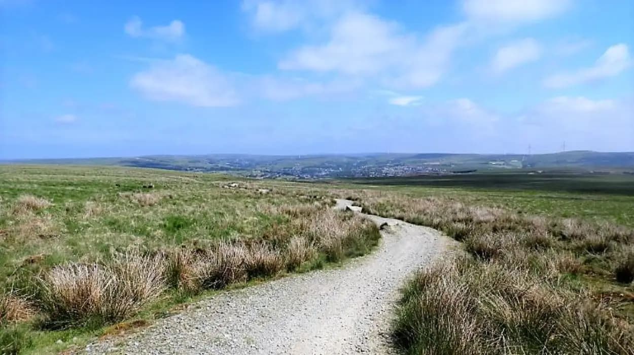
Blackrod developed around an ancient settlement pattern that predates the Industrial Revolution. The village occupies elevated ground overlooking parts of western Greater Manchester, creating extensive views across surrounding farmland, woodland, reservoirs, and neighbouring settlements.
Unlike many former industrial communities that experienced widespread urban redevelopment, Blackrod retained substantial areas of agricultural land and historic landscape. This continuity allows visitors to understand how traditional Lancashire villages evolved without losing their original rural framework.
The surrounding countryside forms part of the wider Green Belt established during the twentieth century. Green Belt designation restricts inappropriate development while protecting agricultural land, public recreation, biodiversity, and historic landscape character.
Village life remains centred around local institutions including churches, schools, sports clubs, independent businesses, community organisations, and public gathering spaces. These institutions continue social traditions established across several centuries.
Visitors therefore experience both heritage and everyday community life rather than an isolated historic attraction.
How did Blackrod's landscape develop over the centuries?
Blackrod's landscape developed through medieval farming, eighteenth-century transport improvements, nineteenth-century industrial expansion, and twentieth-century environmental conservation. Each historical phase shaped today's combination of farmland, woodland, recreational spaces, reservoirs, canals, and residential neighbourhoods.
The earliest documented settlement developed within an agricultural economy dominated by open-field farming. Medieval farmers cultivated surrounding land while common grazing areas supported livestock production.
Agricultural improvement during the eighteenth century transformed the landscape. Parliamentary enclosure reorganised fields into the hedged boundaries that remain visible across much of the countryside today. Stone walls, hedgerows, and farmsteads still define many routes surrounding the village.
Transport improvements dramatically altered local geography. The construction of the Leeds and Liverpool Canal during the late eighteenth century connected Blackrod with regional markets. Canal engineering introduced bridges, embankments, locks, and towpaths that remain important recreational features.
The arrival of the railway during the nineteenth century strengthened economic growth while encouraging residential expansion. Textile manufacturing, coal mining, quarrying, and engineering industries increased employment without completely replacing surrounding farmland.
Twentieth-century planning policies prioritised environmental protection. Green Belt legislation limited outward urban growth, preserving the village's historic relationship with neighbouring countryside.
Modern visitors therefore encounter landscapes representing over eight centuries of continuous human management.
Which green spaces define Blackrod's outdoor environment today?
Blackrod's outdoor environment includes public parks, woodland, farmland, reservoirs, canal corridors, playing fields, and protected countryside. These spaces support biodiversity, recreation, environmental education, heritage interpretation, and community wellbeing throughout the year.
One of Blackrod's defining characteristics is the proximity of open countryside to residential streets. Within a relatively short walking distance, visitors transition from historic village buildings to agricultural landscapes.
Woodland areas contain native tree species including oak, ash, birch, beech, and sycamore. These habitats support birds, insects, mammals, and seasonal wildflowers that contribute to local biodiversity.
Grassland habitats preserve traditional pasture while supporting grazing livestock that maintain historic agricultural landscapes.
Public recreation grounds provide facilities for organised sport, children's activities, and informal leisure. These community spaces demonstrate how modern planning integrates recreation with environmental management.
The Leeds and Liverpool Canal corridor functions as both a transport heritage asset and an ecological corridor. Aquatic habitats support fish, waterfowl, amphibians, and aquatic vegetation while attracting walkers, cyclists, photographers, and wildlife observers.
Reservoirs surrounding Blackrod provide additional recreational opportunities alongside important environmental functions including water management and wildlife conservation.
Together these environments create a diverse outdoor landscape rarely found within commuting distance of Greater Manchester's urban centres.
How does the surrounding countryside reflect Blackrod's agricultural heritage?
The countryside surrounding Blackrod preserves medieval farming patterns, eighteenth-century enclosure landscapes, historic farmsteads, traditional field boundaries, and long-established public rights of way. These features illustrate continuous agricultural activity despite regional industrialisation and urban development.
Agriculture shaped Blackrod for centuries before industrial growth transformed Lancashire.
Historic field systems remain visible through hedgerows, stone walls, drainage channels, and irregular field boundaries. These features reveal successive phases of agricultural improvement rather than modern large-scale land consolidation.
Many farms surrounding Blackrod continue livestock production, maintaining traditional pasture landscapes characteristic of western Lancashire.
Historic barns and farm buildings demonstrate evolving agricultural technology from timber-framed structures to later stone-built facilities.
Public footpaths frequently follow ancient routes connecting farms, settlements, churches, and neighbouring villages. These pathways originally supported local travel before modern roads became dominant.
Visitors using these paths experience landscapes that closely resemble historical descriptions recorded in estate documents, tithe maps, and nineteenth-century Ordnance Survey mapping.
The agricultural setting therefore remains central to understanding Blackrod's historical identity.
What role does the Leeds and Liverpool Canal play in Blackrod's visitor experience?
The Leeds and Liverpool Canal combines industrial heritage, ecological conservation, recreational walking, cycling opportunities, historic engineering, and scenic landscapes. It remains one of Blackrod's most significant visitor attractions while illustrating Britain's transport revolution during the eighteenth and nineteenth centuries.
Construction of the canal began in 1770, with successive sections completed over several decades. The waterway connected Liverpool's maritime trade with manufacturing districts across Lancashire and Yorkshire.
Canal transport dramatically reduced the cost of moving coal, textiles, building materials, agricultural produce, and manufactured goods.
Historic bridges, towpaths, stone retaining walls, and engineering structures survive along the route near Blackrod.
Modern restoration programmes have transformed former industrial infrastructure into recreational assets. Walkers and cyclists now share routes once occupied by horse-drawn barges.
Canal-side vegetation creates valuable wildlife habitat supporting kingfishers, herons, swans, ducks, dragonflies, and aquatic plant communities.
The canal also offers visitors an opportunity to observe how historic engineering integrates with contemporary environmental management.
To experience this historic landscape in person today, consult our comprehensive guide for itineraries and visiting parameters.
The Hidden History of Blackrod: How a Small Village Shaped Northern Bolton
How do walking routes help visitors understand Blackrod's heritage?
Walking routes connect historic buildings, agricultural landscapes, canal infrastructure, woodlands, churches, reservoirs, and conservation areas. These routes enable visitors to interpret Blackrod's historical development through surviving physical landscapes rather than isolated monuments.
Walking remains one of the most effective ways to understand the village's historical geography.
Routes frequently begin within the historic village centre before extending into the surrounding countryside. This transition illustrates how settlement expanded while retaining strong connections with agriculture.
Public footpaths often intersect ancient routeways used by farmers, traders, religious pilgrims, and local residents for generations.
Interpretation boards, heritage publications, and mapping resources explain local history alongside ecological information.
Walking also highlights changes in land use. Visitors observe former industrial sites that have become wildlife habitats, recreational land, or restored green spaces.
Seasonal variation enhances visitor experiences throughout the year. Spring reveals woodland wildflowers, summer supports rich biodiversity, autumn highlights historic woodland colours, and winter improves visibility across surrounding landscapes.
These routes therefore combine recreation with historical education.
How has Blackrod preserved its village character despite modern development?
Blackrod preserved its village character through conservation planning, Green Belt protection, historic building maintenance, community organisations, careful residential expansion, and continued use of public spaces that reinforce long-established patterns of local social interaction.
Population growth increased substantially during the nineteenth and twentieth centuries as improved transport encouraged commuting into Bolton, Manchester, Wigan, and surrounding employment centres.
Despite this growth, planning authorities protected significant historic features.
Residential development generally expanded beyond the historic core rather than replacing it entirely.
Historic churches remain prominent landmarks that continue serving religious and community functions.
Local schools, sports clubs, voluntary organisations, and community events strengthen village identity by maintaining traditions across successive generations.
Independent businesses contribute to a distinctive local economy while supporting everyday village life.
Conservation policies encourage sympathetic restoration of older buildings using appropriate materials and architectural styles.
The result is a settlement that balances modern housing needs with preservation of historic character.
Which historic landmarks contribute to Blackrod's community atmosphere?
Historic churches, traditional cottages, canal infrastructure, railway heritage, former industrial buildings, memorials, and conservation areas contribute to Blackrod's distinctive community atmosphere while preserving visible evidence of its historical development across several centuries.
Historic buildings provide continuity between past and present.
Stone-built cottages reflect traditional Lancashire construction techniques using locally available materials.
Churches occupy central positions within the historic settlement pattern and continue hosting religious services, community events, educational activities, and heritage programmes.
War memorials commemorate residents who served during the First and Second World Wars, preserving local historical memory.
Former industrial buildings demonstrate Blackrod's contribution to Lancashire's textile and mining economy. Although many have found new uses, their architectural form continues documenting nineteenth-century economic change.
Historic railway infrastructure illustrates the transformation of regional transportation during the Victorian era.
Together these landmarks create a coherent historic environment rather than isolated heritage attractions.
How does wildlife contribute to Blackrod's environmental importance?
Wildlife habitats across woodlands, waterways, grasslands, hedgerows, and farmland support diverse bird, mammal, insect, amphibian, and plant species. These habitats demonstrate successful coexistence between historical landscapes, modern recreation, and biodiversity conservation.
Blackrod's ecological diversity results from varied habitats developed over centuries.
Woodland supports nesting birds including woodpeckers, owls, robins, blue tits, and great spotted woodpeckers.
Canal and reservoir environments attract waterfowl including mute swans, mallards, moorhens, coots, and grey herons.
Hedgerows function as wildlife corridors linking fragmented habitats across agricultural land.
Wildflower meadows provide nectar sources for bees, butterflies, hoverflies, and other pollinating insects essential for ecosystem health.
Seasonal migration introduces additional bird species during spring and autumn.
Environmental organisations encourage habitat management through woodland restoration, invasive species control, native planting, and public education.
These conservation efforts strengthen both biodiversity and visitor experience.
Why is community life central to understanding Blackrod today?
Community life remains central because local organisations, cultural traditions, sports clubs, schools, churches, volunteer groups, and public events preserve social connections that have shaped Blackrod's identity across generations despite significant economic and demographic change.
Village identity extends beyond historic buildings.
Community organisations organise seasonal celebrations, charity events, educational programmes, sports competitions, and heritage initiatives that strengthen social cohesion.
Local schools introduce younger generations to Blackrod's history through educational partnerships with heritage organisations and community volunteers.
Volunteer groups contribute to environmental conservation through litter collection, habitat restoration, canal maintenance, and historical interpretation projects.
Sports clubs maintain recreational traditions established during the nineteenth century when organised leisure became increasingly important within industrial communities.
Independent shops, cafés, and community facilities provide meeting places that reinforce everyday social interaction.
This active civic culture ensures heritage remains part of contemporary life rather than existing solely as historical interpretation.
How do conservation efforts protect Blackrod for future generations?
Conservation efforts protect historic buildings, archaeological remains, biodiversity, public footpaths, waterways, landscapes, and community heritage through planning regulation, environmental management, volunteer participation, educational programmes, and long-term preservation strategies.
Protection begins with planning policies that recognise the importance of historic landscapes alongside modern development.
Green Belt designation limits inappropriate expansion while safeguarding countryside surrounding the village.
Historic buildings receive protection through conservation legislation, maintenance programmes, and sensitive restoration.
Environmental management improves woodland health, protects water quality, restores habitats, and encourages sustainable public access.
Public rights of way receive ongoing maintenance to preserve accessibility while reducing environmental damage.
Educational programmes organised by local authorities, heritage organisations, schools, and volunteer groups increase public understanding of Blackrod's historical significance.
Academic research, historic mapping, archaeological surveys, and archival documentation continue improving knowledge of the village's development.
These combined efforts ensure Blackrod remains both a living community and an accessible historical landscape.
Blackrod represents an outstanding example of how historic Lancashire villages adapted to centuries of economic, social, and environmental change while preserving their essential landscape character. Medieval agriculture established the settlement's foundations. Eighteenth-century transport improvements connected the village to wider regional markets. Nineteenth-century industrialisation expanded employment and population. Twentieth-century conservation policies protected surrounding countryside and historic character. Modern community organisations continue sustaining local identity through active participation in heritage, recreation, education, and environmental stewardship.
Visitors encounter far more than attractive scenery. They experience an interconnected landscape where canals, woodlands, farmland, churches, public footpaths, reservoirs, conservation areas, and historic buildings collectively explain the evolution of one of Bolton's most distinctive villages. This combination of accessible green spaces and authentic village life makes Blackrod an enduring destination for history enthusiasts, cultural tourists, educators, genealogists, and anyone seeking to understand how historical landscapes continue shaping modern communities.
FAQS
What is Blackrod best known for?
Blackrod is best known for its historic village character, industrial heritage, scenic countryside, the nearby Leeds and Liverpool Canal, and an extensive network of walking routes that combine natural landscapes with local history.