Blackrod, located on the western edge of the Metropolitan Borough of Bolton in Greater Manchester, offers one of the area's richest combinations of industrial heritage, rural landscapes, transport history, and historic architecture. Walking through the village reveals centuries of continuous development, from medieval settlement patterns and agricultural fields to coal mining, textile production, canals, railways, and modern conservation initiatives.
Unlike larger urban centres where historical features often become disconnected from one another, Blackrod's compact layout allows visitors to experience multiple historical periods within a relatively short walking distance. Historic churches, former mining districts, surviving transport infrastructure, public parks, and countryside footpaths combine to create an accessible heritage landscape suitable for recreational walkers, educators, historians, and cultural tourists.
Walking also provides an opportunity to understand how geography shaped Blackrod's development. Elevated ground, surrounding moorland, nearby coal seams, and strategic transport corridors all influenced settlement expansion over several centuries. Many surviving landmarks continue to demonstrate these historical relationships today.
Why is Blackrod an excellent destination for heritage walking?
Blackrod combines medieval origins, Industrial Revolution landmarks, preserved countryside, historic transport routes, and accessible public footpaths within a compact area. This unique concentration enables visitors to understand centuries of historical development while exploring significant local architecture, landscapes, and surviving industrial heritage entirely on foot.
Blackrod developed from a medieval township into an important industrial community between the eighteenth and twentieth centuries. Unlike purpose-built Victorian towns, much of its historic street pattern follows earlier routes established hundreds of years before industrialisation.
Walking allows visitors to appreciate this gradual evolution. Churches stand near former agricultural land, Victorian housing borders ancient footpaths, and former railway corridors connect with open countryside. Each stage of development remains visible within the landscape.
The village also benefits from excellent public rights of way connecting residential streets with woodland, farmland, reservoirs, canals, and neighbouring settlements. These routes create varied walking experiences suitable for different interests and fitness levels.
Blackrod's location between Bolton, Horwich, Adlington, and Westhoughton also places it within the wider historical geography of south-west Lancashire, where coal mining, textile manufacturing, and transport innovation transformed the region during the Industrial Revolution.
Which walking route best introduces Blackrod's historic centre?
A circular walk through Blackrod village centre introduces its medieval street pattern, historic parish church, traditional stone buildings, former commercial properties, and Victorian civic development. This accessible route provides an excellent overview of the settlement's architectural and historical evolution across multiple centuries.
The historic core remains the ideal starting point for understanding Blackrod's development.
Beginning near the village centre allows walkers to observe the gradual transition from medieval settlement to nineteenth-century expansion. Roads follow long-established alignments that connected farms, churches, and neighbouring communities before modern transport networks emerged.
Many surviving buildings display locally quarried sandstone, reflecting regional construction traditions. Stone cottages, former inns, commercial buildings, and later Victorian houses demonstrate changing architectural styles while maintaining a coherent historic character.
Public spaces within the centre illustrate how communities organised markets, worship, education, and commerce before widespread motor transport reshaped village layouts.
The route also introduces visitors to several listed buildings whose preservation helps maintain Blackrod's historic identity.
To experience this historic landmark in person today, consult our comprehensive [Blackrod’s Industrial Past: Coal, Transport, and Community Development Explained] for itineraries and visiting parameters.
What makes St Katharine's Church one of Blackrod's most significant landmarks?
St Katharine's Church represents Blackrod's religious, architectural, and social history through centuries of continuous worship, community life, and architectural development. The church preserves medieval foundations alongside later restoration work that reflects changing religious practices and population growth across successive historical periods.
The Parish Church of St Katharine forms one of Blackrod's most important surviving historic landmarks.
Although portions of the present building date from later reconstruction and restoration campaigns, documentary evidence confirms that Christian worship existed here for centuries. The church served as the spiritual centre of the township while also recording baptisms, marriages, and burials that now support genealogical research.
Churchyards preserve memorials representing multiple generations of local families. These monuments provide valuable evidence regarding occupations, mortality, family relationships, and demographic change.
Architecturally, the church reflects several construction phases rather than one single building campaign. Stone masonry, windows, roof structures, and interior features demonstrate changing architectural preferences across different historical periods.
The church also illustrates the importance of parish institutions before modern local government assumed responsibility for many social functions.
How did Blackrod's countryside shape its walking routes?
Blackrod's surrounding countryside determined settlement patterns, farming practices, transport corridors, and industrial expansion. Modern walking routes follow ancient field boundaries, historic rights of way, woodland tracks, canal paths, and upland landscapes that preserve evidence of centuries of human interaction with the natural environment.
Long before industrialisation, agriculture dominated Blackrod's economy.
Farmsteads occupied elevated land with access to pasture, water, and transport routes. Footpaths connected isolated farms with markets, churches, and neighbouring settlements.
Many of today's public footpaths follow these historic alignments.
Woodland areas preserve remnants of older landscapes that survived industrial expansion. Hedgerows often indicate historic field boundaries dating back hundreds of years.
Seasonal variations further enhance walking experiences by revealing changing vegetation, wildlife habitats, and landscape character throughout the year.
The countryside also provides valuable ecological continuity alongside cultural heritage, demonstrating how natural and human histories remain closely connected.
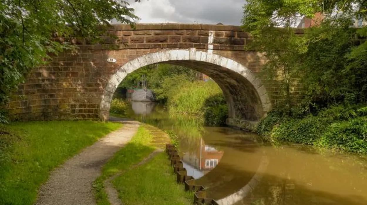
How did the Leeds and Liverpool Canal influence Blackrod?
The Leeds and Liverpool Canal transformed Blackrod by improving freight transport, supporting industrial growth, reducing transportation costs, and connecting local industries with national markets. Today its towpaths provide scenic walking routes while preserving important engineering achievements from Britain's canal-building era.
Completed during Britain's canal age, the Leeds and Liverpool Canal became one of northern England's most significant transport corridors.
Coal, stone, textiles, agricultural goods, and manufactured products travelled efficiently between Lancashire and Yorkshire using this inland waterway.
The canal reduced transport costs compared with road haulage and encouraged industrial investment throughout the surrounding region.
Modern walkers benefit from preserved towpaths that now serve recreational rather than commercial purposes.
Historic bridges, locks, mileposts, and canal engineering remain visible, demonstrating eighteenth- and nineteenth-century civil engineering techniques.
Interpretation of these surviving structures helps visitors understand Britain's transport revolution before railway dominance.
What evidence of Blackrod's industrial heritage remains today?
Blackrod retains substantial evidence of its industrial past through former mining landscapes, railway infrastructure, workers' housing, transport corridors, historic street layouts, and surviving public buildings. These features collectively document the community's transformation during Britain's Industrial Revolution and subsequent economic changes.
Coal mining fundamentally reshaped Blackrod between the eighteenth and twentieth centuries.
Extensive coal seams supported local collieries that employed large numbers of residents. Mining influenced settlement expansion, housing construction, education, commerce, and transport investment.
Although most mining infrastructure has disappeared, landscape features continue to reveal former industrial activity.
Victorian terraced housing constructed for industrial workers remains a defining element of several streets.
Former railway alignments, embankments, bridges, and station locations also illustrate the close relationship between transport and industrial production.
Industrial archaeology allows visitors to identify subtle evidence that survives despite redevelopment.
Understanding these remnants provides valuable insight into the economic forces that transformed Blackrod from a rural settlement into an industrial community.
How do local parks and green spaces contribute to Blackrod's heritage?
Blackrod's parks, recreation grounds, woodlands, and protected green spaces preserve historic landscapes while supporting biodiversity, public health, and cultural identity. These environments demonstrate how former agricultural and industrial land has been adapted for community recreation and environmental conservation.
Public open spaces represent an important chapter in Blackrod's more recent history.
Victorian and twentieth-century urban planning increasingly recognised the importance of accessible recreational land for growing industrial populations.
Former agricultural fields, reclaimed industrial land, and managed woodland now provide opportunities for walking, wildlife observation, and environmental education.
These spaces also preserve historic landscape features including mature trees, traditional boundaries, watercourses, and older pathways.
Local conservation efforts balance public access with habitat protection, ensuring that both natural and cultural heritage remain accessible for future generations.
Walking through these landscapes demonstrates how heritage preservation extends beyond individual buildings.
Which architectural landmarks should walkers look for?
Walkers should observe Blackrod's parish church, historic cottages, Victorian terraces, traditional farm buildings, stone walls, former commercial premises, railway structures, and canal engineering. Together these landmarks illustrate changing architectural styles, construction techniques, and community development across several centuries.
Blackrod's architecture reflects continuous adaptation rather than complete redevelopment.
Traditional sandstone construction dominates many older buildings, demonstrating the availability of local building materials.
Victorian housing introduced more uniform terraces designed for expanding industrial workforces.
Former schools, chapels, public houses, and commercial buildings reveal changing social priorities during the nineteenth century.
Railway bridges, retaining walls, and engineering structures demonstrate advances in transport infrastructure.
Architectural diversity provides evidence of economic prosperity, technological innovation, and evolving community needs.
Careful observation reveals differences in masonry techniques, roofing materials, window styles, and decorative details across successive building periods.
How does Blackrod connect with neighbouring historic landscapes?
Blackrod forms part of a wider historic landscape linking Bolton, Horwich, Adlington, Haigh, and Westhoughton through ancient roads, canals, railways, agricultural land, and industrial heritage. Walking routes reveal how neighbouring communities developed through shared economic and geographical influences.
Blackrod never developed in isolation.
Its economy depended upon strong regional connections established through agriculture before expanding dramatically during industrialisation.
Historic routes linked Blackrod with nearby markets, churches, mining districts, and manufacturing centres.
Later, canals and railways strengthened these relationships by improving freight movement and passenger travel.
Modern walking routes frequently extend beyond parish boundaries into neighbouring landscapes, allowing visitors to understand broader historical patterns across Greater Manchester and Lancashire.
Regional interpretation enriches understanding of Blackrod by placing local landmarks within wider economic and social developments.
How are Blackrod's historic walking routes preserved for future generations?
Historic walking routes are preserved through listed building protection, public rights of way legislation, conservation policies, heritage organisations, environmental management, and community engagement. These combined approaches protect important landscapes while maintaining public access for education, recreation, and historical interpretation.
Heritage preservation involves multiple organisations working together.
Listed buildings receive statutory protection that regulates inappropriate alteration.
Public footpaths remain protected through long-established rights of way legislation, ensuring continued public access.
Local planning authorities consider heritage significance when evaluating development proposals affecting historic landscapes.
Historical societies document buildings, archival records, photographs, and oral histories that improve understanding of local heritage.
Environmental management also supports preservation by maintaining woodland, waterways, wildlife habitats, and traditional landscapes.
Educational walking events encourage community participation while promoting appreciation of Blackrod's cultural significance.
Digital mapping, heritage interpretation panels, and archival digitisation further improve public access to historical information.
Why does exploring Blackrod on foot provide a deeper understanding of local history?
Walking allows visitors to experience Blackrod's historical development chronologically within its original landscape. Observing streets, churches, waterways, countryside, industrial remnants, and architectural landmarks together reveals the interconnected processes that shaped the village over several centuries.
Walking provides perspectives unavailable from vehicle travel.
Distances between landmarks become meaningful, illustrating how residents once travelled for work, worship, education, and trade.
Changes in elevation explain settlement patterns and transport engineering decisions.
Historic buildings gain additional significance when viewed alongside surrounding landscapes rather than in isolation.
The combination of rural scenery, industrial heritage, and preserved architecture demonstrates the remarkable continuity of Blackrod's historical development.
For historians, educators, genealogists, and cultural tourists, these interconnected landscapes provide valuable evidence of changing economic activity, social organisation, religious life, and environmental management.
As conservation efforts continue, Blackrod remains an accessible example of how historic communities evolve while retaining tangible connections to their medieval origins, industrial expansion, and modern heritage preservation. Exploring its walking routes not only encourages appreciation of the local landscape but also deepens understanding of the wider historical transformation of Greater Manchester and north-west England.
FAQS
How long does it take to walk around Blackrod?
Most heritage walks around Blackrod's historic centre take between 1.5 and 3 hours, depending on the route, pace, and number of stops. Longer walks that include the Leeds and Liverpool Canal or surrounding countryside can take half a day.