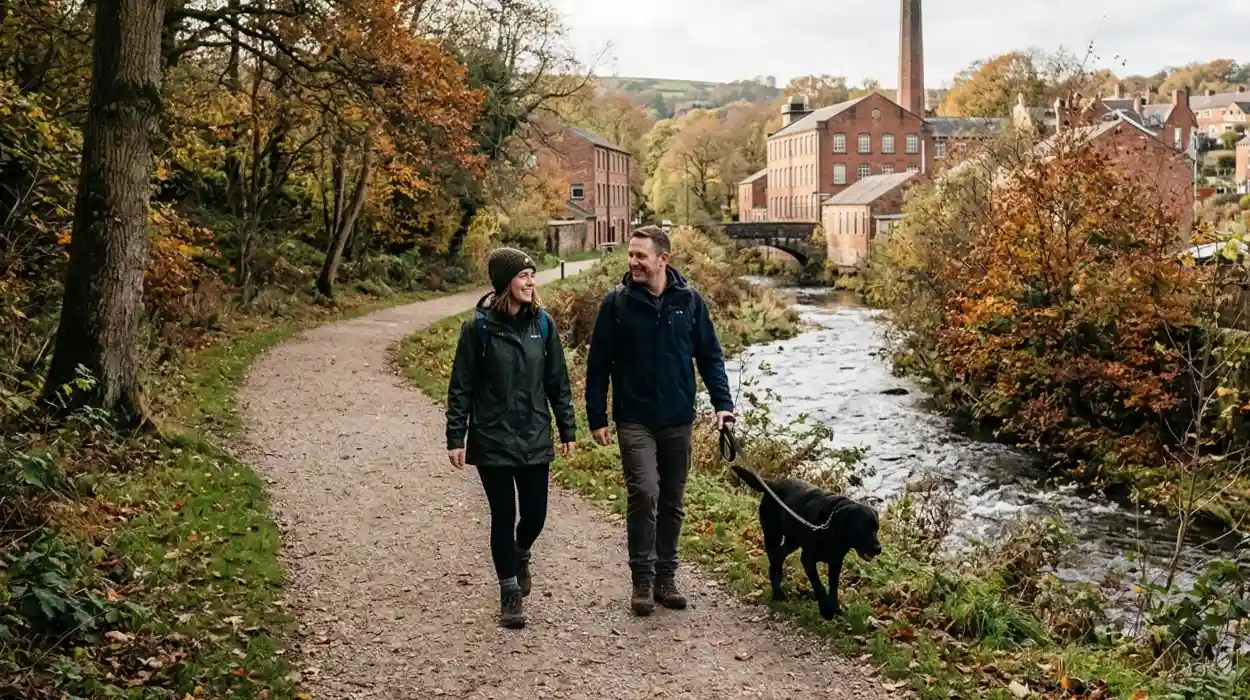
Astley Bridge is a distinct township located approximately 3.0 kilometers north of Bolton town center in Greater Manchester. Historically designated as Lower Sharples, this urban settlement underwent significant expansion during the Industrial Revolution, transitioning from an agricultural clearing into a major textile manufacturing hub. The geographical layout of the district is defined by its positioning over the Astley Brook valley, a vital waterway that historically powered local industry. In the modern era, Astley Bridge serves as a vital suburban corridor, combining industrial heritage architecture with conservation areas, public walking trails, and a diverse culinary sector. This official travel guide by Bolton Today outlines the core infrastructure, historical landmarks, pedestrian routes, and retail amenities available to domestic and international visitors.
What is the history of Astley Bridge?
Astley Bridge originated as an agricultural clearing named Lower Sharples before transforming into a productive industrial township during the nineteenth century. The district specialized in automated cotton spinning, powered by local waterways and an urban transport network connecting Bolton to northern manufacturing centers.
The etymology of the geographic name derives from the Old English words leah, meaning a forest clearing, and ast, signifying ash trees, which establishes the original landscape as a clearing in the ash trees. The transition from a rural hamlet to an industrial center accelerated in the mid-1800s. The construction of the core transport artery, Blackburn Road (classified as the A666), facilitated the movement of raw materials and finished goods between the industrial hubs of Bolton and Blackburn.
Industrialization led to the construction of large-scale manufacturing infrastructure. The primary industrial asset in the district was the Astley Bridge Mill, which stands as the final major textile mill erected in the Bolton borough. This multi-story red brick facility utilized advanced steam-powered machinery to process raw cotton. The influx of textile laborers necessitated rapid residential construction, establishing the grid iron street patterns of terraced housing that continue to characterize the local built environment.
The economic expansion of the nineteenth century altered the social structure of the area. Wealthy industrialists funded civic and charitable projects to support the growing population. A prominent example is Eden’s Orphanage, built on Thorns Road to provide housing and education for displaced children. Additionally, religious organizations established prominent structures, such as St. Paul’s Church and the Seymour Road Theatre Church, which functioned as community anchors. These nineteenth-century institutional buildings survive today as protected architectural assets, preserving the Victorian character of the township.
Where are the best walking routes in Astley Bridge?
The best walking routes in Astley Bridge utilize the preserved industrial infrastructure and natural valleys of the Astley Brook, Eagley Brook, and Raveden Clough. These pedestrian paths offer flat tarmac terrain, woodland trails, and historical landmarks for recreational walkers.
Recreational walking in Astley Bridge centers on the river valleys that carved the local landscape. The Astley Brook and Eagley Brook paths provide pedestrian corridors that isolate walkers from the urban traffic of the A666. These routes are accessible via multiple entry points, including Crompton Way and Blackburn Road, allowing visitors to customize their distance. The paths feature a combination of earth trails, crushed stone surfaces, and paved public footpaths suitable for varied fitness levels.
The most prominent historical walking route connects Astley Bridge to the Hall i' th' Wood Museum, located directly east of the central district off Crompton Way. This path takes walkers through a transition from urban streets to a dedicated green space surrounding a Grade I listed sixteenth-century manor house. The property is historically significant as the residence of Samuel Crompton, who invented the spinning mule in 1779. The surrounding grounds feature mature native trees, managed grass lawns, and clear directional signage detailing the industrial heritage of the estate.
For more advanced terrain, the trail network extends northward into Sharples and the Raveden Clough valley. This area provides woodland walking routes that follow the natural topography of the clough, a traditional northern English term for a steep-sided valley. The paths connect directly to wider regional trail systems, such as the Kingfisher Trail, which spans 11 kilometers across the Bolton borough. Walkers on these routes encounter diverse biological environments, including ancient semi-natural woodlands, wetlands, and structural remains of old water management systems used by early textile operations.
Explore More Things To Do In Bolton
Ironman UK Spectator and Road Closure Guide: Bolton 2026
Complete Scientific Climate and Meteorology Analysis for Greater Manchester, Bolton 2026
What are the top cafes and dining spots in Astley Bridge?
The top dining spots in Astley Bridge are concentrated along Blackburn Road and Hill View Road, featuring independent cafes, historical steakhouses, and authentic South Asian restaurants. These establishments provide breakfast, gourmet baked goods, international fusion dishes, and formal evening dining options.
The morning and afternoon culinary trade in Astley Bridge centers on traditional British cafe culture and community-driven initiatives. A notable example is The Old Bank Café, situated on Hill View Road. This venue has a 4.8-star consumer rating and operates to generate financial resources for the Bolton Hospice, a local palliative care facility. The menu consists of traditional full English breakfasts, artisan pasties, homemade cakes, and specific dietary selections, including vegan and vegetarian alternatives.
The evening dining infrastructure is defined by its international diversity, representing the multicultural demographics of Greater Manchester. Blackburn Road hosts long-standing institutions like The Pavilion Indian Restaurant, which has provided traditional South Asian cuisine for more than 20 years. The establishment specializes in large-portion curries, utilizing classic regional spice blends. For modern culinary variations, the New Dhanak Deira, located inside a converted historical church building on Blackburn Road, offers an Indo-Chinese fusion menu featuring specialized items, such as Chicken Lollipop and Lamb Manchurian.
Premium dining is represented by the Beefalo Meat House, located on Blackburn Road. Under the operational leadership of Chef Yuce, this upscale steakhouse specializes in prime dry-aged steaks, utilizing specialized cuts of beef prepared on artisanal grills. For traditional regional fare, local heritage vendors provide standard British food options. Examples include Su's Fish & Chips, which serves traditional battered cod and triple-cooked chips, and Armstrongs Bakers, a regional bakery providing handcrafted meat pies and traditional English pasties.
What scenic spots can tourists visit in Astley Bridge?
The primary scenic spots in Astley Bridge encompass the historical architecture of Hall i' th' Wood, the industrial ruins along Eagley Brook, and the panoramic views from nearby high-elevation points like Cheetham Close and Rivington Pike.
The architectural scenery of the district is anchored by its Grade I and Grade II listed buildings. Hall i' th' Wood presents a visually striking example of timber-framed Tudor architecture combined with later seventeenth-century stone additions. The contrast between the black-and-white post-and-pan timber work and the local gritstone masonry provides an authentic visual record of regional housing evolution over 400 years. The structural profile of the building, set against an elevated wood, makes it a primary location for architectural photography.
The industrial scenic landscape features the preserved remnants of the textile economy. The Astley Bridge Mill retains its distinct green tower, visible from multiple vantage points along the A666 corridor. Walking along the Eagley Brook Way reveals old mill lodges, which were artificial reservoirs designed to store water for manufacturing processes. These lodges have underwent naturalization, transforming into urban wildlife habitats where tourists observe native waterfowl, including grey herons, kingfishers, and mallards, framed by original stone retaining walls.
The geographical positioning of Astley Bridge provides immediate visual access to the West Pennine Moors. Traveling less than two kilometers north brings visitors to elevated scenic viewpoints. The top three nearby high-elevation points are:
- Cheetham Close: An upland moorland featuring a historic stone circle and a triangulation station at an elevation of 327 meters, providing views over the Bolton borough.
- Two Lads' Cairn: A historical upland site featuring dual stone mounds that provides a 360-degree panoramic view of the Greater Manchester urban conurbation.
- Rivington Pike: A landmark summit at 363 meters featuring a stone hunting lodge built in 1733, offering clear visibility extending to the Irish Sea on clear days.
How can visitors navigate Astley Bridge?
Visitors navigate Astley Bridge via the A666 road corridor using public bus transport, private vehicles, or pedestrian paths. The district connects directly to the national rail network through nearby stations at Hall i' th' Wood and Bolton Interchange.
The spatial layout of Astley Bridge is linear, organized along the north-south axis of Blackburn Road (A666). This road serves as the primary conduit for all vehicular traffic entering from the center of Bolton or descending from the northern boundary of Blackburn. For visitors traveling by private vehicle, multiple managed parking facilities exist. The Valley Entertainment Centre, located in the southern sector of the district, provides extensive surface parking, while central retail zones offer dedicated short-stay spaces for shoppers.
Public transport infrastructure is managed by Transport for Greater Manchester (TfGM). High-frequency bus routes, including the 501, 1, and 2 services, operate along Blackburn Road at intervals of approximately 10 to 15 minutes during standard daylight hours. These bus lines connect Astley Bridge directly to the Bolton Interchange, a major transport hub providing onward connections to Manchester City Centre, Manchester Airport, and regional destinations across Lancashire.
For rail travelers, the closest active passenger terminal is the Hall i' th' Wood railway station, positioned on the Ribble Valley Line. This unstaffed station is located roughly 1.5 kilometers east of the central Blackburn Road junction. Northern Trains operates hourly services through this station, linking passengers directly to Blackburn, Clitheroe, and Manchester Victoria station. Pedestrian navigation within the district is supported by continuous sidewalks, controlled pedestrian crossings at major intersections, and public directional signage marking the entrances to off-road walking trails.
What is the economic and future impact of tourism in Astley Bridge?
The economic impact of tourism in Astley Bridge centers on the revitalization of industrial architecture into commercial assets and the growth of independent retail and hospitality venues. This diversification shifts the local economy from manufacturing to a service and heritage-based model.
The modern economic structure of Astley Bridge is no longer dependent on raw material manufacturing. The closure of the historic textile mills throughout the twentieth century required a structural shift toward retail, hospitality, and cultural tourism. Property development firms have progressively converted historic industrial mills into modern commercial spaces, including catalogue warehouses, office suites, and multi-use fitness complexes. This adaptive reuse preserves the external historic fabric while generating local employment and business rates.
The hospitality sector acts as a primary driver of weekend economic activity. The concentration of diverse restaurants on Blackburn Road draws consumers from outside the immediate borough, increasing evening expenditure in the area. According to regional tourism metrics for Greater Manchester, visitors seeking authentic heritage and independent culinary experiences spend an average of 45% more in local economies compared to visitors utilizing corporate chain facilities. This expenditure directly supports independent business owners and creates entry-level employment opportunities for residents.
The future relevance of Astley Bridge relies on its integration into the wider green tourism initiatives of the Bolton Council. Strategic planning policies emphasize the protection and enhancement of the Kingfisher Trail and the Eagley Brook conservation areas. By linking urban heritage structures with accessible natural trails, Astley Bridge is positioned to capture a growing market of eco-conscious day-trippers. This long-term sustainable development model ensures the township maintains its distinct historical identity while securing economic resilience in a modern service-driven landscape.
FAQS
Where is Astley Bridge located?
Astley Bridge is located around 3 kilometers north of Bolton town centre along the A666 Blackburn Road corridor.