Astley Bridge is one of the most accessible gateways to outdoor recreation in northern Bolton. Located on the northern edge of the town, the area connects urban neighbourhoods with parks, reservoirs, woodland paths, canal-side routes, and upland countryside. Walking routes around Astley Bridge offer a combination of natural scenery, industrial heritage, and local history that reflects the wider development of Bolton and Lancashire.
For visitors seeking walking and nature experiences, Astley Bridge provides direct access to some of the most important green spaces in the borough. These routes reveal the area's industrial past, Victorian landscape planning, water infrastructure, and continuing conservation efforts. The trails remain popular among residents, tourists, educators, and heritage researchers interested in understanding how Bolton's landscape evolved from rural farmland into an industrial centre and later into a modern recreational destination.
Why is Astley Bridge an important starting point for walking routes in Bolton?
Astley Bridge serves as a strategic access point to Bolton's northern parks, reservoirs, woodland paths, and historic transport corridors. Its location connects urban communities with protected green spaces while preserving evidence of industrial, environmental, and recreational development spanning more than two centuries.
The district developed rapidly during the nineteenth century as Bolton expanded during the Industrial Revolution. Textile mills, worker housing, transport links, and public infrastructure transformed the area. Despite urban growth, significant open land survived around the settlement.
Today, walkers can reach multiple landscapes within a short distance. These include public parks, river corridors, reservoir paths, former industrial routes, and countryside trails. The concentration of accessible green spaces distinguishes Astley Bridge from many urban districts in Greater Manchester.
The area's geography contributes significantly to its walking appeal. Located near the foothills of the West Pennine Moors, Astley Bridge provides gradual transitions between built environments and open countryside. This creates varied walking experiences suitable for casual visitors, families, heritage enthusiasts, and experienced hikers.
Bolton Council's green infrastructure network links many of these routes, helping preserve ecological habitats while providing recreational opportunities for residents and visitors.
Which parks around Astley Bridge offer the best walking experiences?
Several parks near Astley Bridge provide established walking routes, mature woodland, landscaped gardens, wildlife habitats, and historical features. These spaces demonstrate how Victorian and twentieth-century planners integrated recreation, public health, and environmental conservation into Bolton's urban development.
The most prominent park near Astley Bridge is Moss Bank Park. Opened in 1926, the park occupies more than 84 hectares of landscaped land. The site contains woodland trails, formal gardens, open meadows, and recreational facilities.
Moss Bank Park reflects the wider movement for public parks that emerged across industrial Britain during the late nineteenth and early twentieth centuries. Municipal authorities recognised that access to green space improved public health in densely populated industrial towns.
Walking routes through the park pass mature trees, ponds, and ornamental landscapes. Seasonal changes create varied scenery throughout the year. The park also supports local biodiversity through habitat management initiatives.
Another important green space is Doffcocker Lodge and surrounding parkland. Originally associated with water management infrastructure, the area evolved into a valued recreational landscape. Walking paths around the lodge provide opportunities to observe waterfowl and native wildlife.
Smaller neighbourhood parks contribute additional walking opportunities. Together, these green spaces form a network that connects residential districts with larger countryside routes.
To experience these historic landscapes in person today, consult our comprehensive [The Industrial Heritage of Astley Bridge: Mills, Workers, and Urban Expansion] for itineraries and visiting parameters.
How do canal and waterway routes contribute to walking opportunities near Astley Bridge?
Waterway corridors create accessible walking environments that combine industrial heritage, ecological value, and scenic views. These routes preserve evidence of nineteenth-century transport systems while supporting modern recreation, conservation, and environmental education throughout the Bolton area.
Although Astley Bridge itself is not directly situated on a major canal, nearby waterways form an important part of the wider walking network accessible from the district.
The Manchester, Bolton and Bury Canal represents one of the region's most significant historic transport corridors. Construction began in 1791 and sections opened during the 1790s. The canal played a critical role in transporting coal, textiles, and industrial goods during Bolton's period of rapid economic growth.
Today, restored sections and associated towpaths offer walking opportunities that combine history and nature. Visitors can observe surviving engineering features, including locks, bridges, and embankments.
Canal-side environments support diverse ecosystems. Wetland habitats attract birds, insects, amphibians, and aquatic species. Conservation projects have improved biodiversity while preserving industrial archaeology.
Walking routes along former transport corridors illustrate the transformation of industrial infrastructure into recreational assets. This pattern reflects wider heritage preservation strategies across northern England.
Water management systems also shaped the landscape around Bolton. Reservoirs, lodges, streams, and drainage channels originally supported industrial production and urban expansion. Many now function as recreational resources.
What role do reservoirs play in scenic walking routes around Astley Bridge?
Reservoir walking routes combine dramatic landscapes, engineering heritage, wildlife habitats, and panoramic views. These water bodies were constructed primarily to support industry and public supply but now serve important recreational and environmental functions across northern Bolton.
The reservoirs north of Bolton represent some of the most attractive walking destinations accessible from Astley Bridge.
Jumbles Reservoir is among the most popular examples. Created in the late eighteenth century to support industrial activity, the reservoir now attracts thousands of visitors annually. Circular walking routes around the water provide relatively easy terrain suitable for a broad range of users.
The surrounding woodland creates a diverse ecological environment. Native trees, birds, and aquatic habitats contribute to the area's conservation value.
Wayoh Reservoir offers another significant walking destination. Constructed during the nineteenth century, it became part of Bolton's expanding water supply infrastructure. The reservoir occupies a scenic valley surrounded by wooded slopes and open countryside.
Walking paths around Wayoh Reservoir provide opportunities to observe both natural and engineered landscapes. The combination of water, woodland, and upland scenery creates distinctive visual appeal.
Turton and Entwistle Reservoir extends the network further north. Opened in 1838, it remains an important historical example of Victorian water engineering. Walking routes around the reservoir connect with broader countryside trails throughout the West Pennine Moors.
These reservoirs demonstrate how industrial-era infrastructure continues to shape recreational landscapes more than a century after construction.
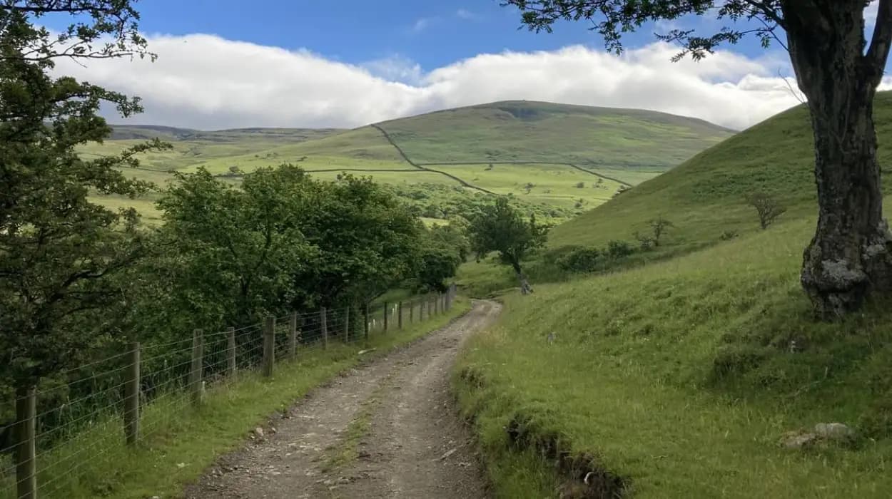
How do the West Pennine Moors influence walking trails near Astley Bridge?
The West Pennine Moors provide elevated terrain, expansive views, archaeological features, and diverse habitats. Their proximity to Astley Bridge allows walkers to transition quickly from urban environments into protected landscapes that preserve centuries of environmental and cultural history.
The West Pennine Moors cover approximately 90 square miles across Lancashire and Greater Manchester. Their upland landscapes have influenced settlement patterns, agriculture, industry, and recreation for centuries.
Walking routes from Astley Bridge often connect directly or indirectly with this wider moorland environment.
The moors contain extensive footpath networks crossing hills, valleys, reservoirs, and open heathland. Many routes follow historic pathways that predate industrialisation.
Archaeological evidence demonstrates human activity across the moors for thousands of years. Remains from prehistoric, medieval, and industrial periods survive throughout the landscape.
The area's ecological importance is equally significant. Moorland habitats support species adapted to upland environments. Conservation efforts focus on protecting biodiversity while maintaining public access.
Elevated sections of the trail network provide panoramic views across Bolton, Lancashire, and Greater Manchester. These viewpoints help visitors understand the geographical relationship between industrial settlements and surrounding countryside.
The West Pennine Moors remain one of the defining landscape features influencing walking experiences around Astley Bridge.
What historical features can walkers discover along Astley Bridge trails?
Walking routes around Astley Bridge reveal surviving evidence of Bolton's industrial, transport, water management, and social history. Mills, reservoirs, bridges, worker housing, and historic pathways illustrate how the region developed between the eighteenth and twentieth centuries.
Industrial heritage remains visible throughout the landscape.
Former mill sites demonstrate the scale of textile manufacturing that drove Bolton's growth during the nineteenth century. Although many mills have disappeared, surviving buildings and associated infrastructure continue to shape local character.
Historic bridges represent another important feature. Road bridges, railway bridges, and canal crossings reflect advances in engineering and transport development.
Water infrastructure appears frequently along walking routes. Reservoir embankments, overflow systems, and supply channels illustrate the technological innovations that supported industrial expansion and urban growth.
Victorian planning principles also remain evident. Public parks, landscaped spaces, and recreational facilities emerged as responses to industrial urbanisation.
Religious buildings, schools, and civic institutions encountered along some routes provide insight into community development. These structures often served growing populations associated with textile manufacturing.
Historic maps reveal that many modern walking paths follow older routes originally used for agriculture, transport, or industry. This continuity enhances the educational value of walking experiences around Astley Bridge.
How have conservation efforts protected walking environments around Astley Bridge?
Conservation initiatives have preserved habitats, restored historic landscapes, improved public access, and protected heritage assets. These programmes ensure that walking routes continue supporting recreation, biodiversity, education, and cultural heritage throughout the Bolton area.
Environmental conservation became increasingly important during the late twentieth century.
Local authorities, environmental organisations, and community groups have worked to improve green spaces and maintain access routes. Habitat restoration projects support wildlife while enhancing visitor experiences.
Woodland management programmes help maintain ecological diversity. Native tree planting and invasive species control contribute to long-term sustainability.
Reservoir environments benefit from ongoing monitoring and conservation activity. Water quality management supports both ecological health and recreational use.
Industrial heritage conservation represents another significant focus. Restoration projects preserve historically important structures while adapting them for contemporary use.
Public footpath maintenance ensures safe access to recreational areas. Signage, route improvements, and accessibility enhancements encourage broader participation in outdoor activities.
These conservation measures demonstrate how environmental and heritage objectives can operate together to protect valuable landscapes.
Why are walking routes around Astley Bridge important for education and heritage tourism?
Walking routes function as open-air classrooms that connect visitors with industrial history, environmental science, geography, and cultural heritage. They support tourism, community identity, and public understanding of Bolton's historical and environmental development.
Educational institutions frequently use local walking routes for field studies. Geography students examine landscape formation, water systems, and land use patterns.
History students investigate industrialisation, transport networks, and urban development. Physical remains within the landscape provide tangible evidence of historical processes.
Genealogical researchers also benefit from these routes. Walking through historic neighbourhoods and industrial districts helps contextualise family histories connected to Bolton's manufacturing economy.
Heritage tourism contributes to the local economy by attracting visitors interested in industrial history, architecture, and cultural landscapes.
Interpretation panels, heritage trails, and conservation projects increase public understanding of significant sites. These initiatives encourage appreciation of local history among residents and visitors alike.
Walking tourism aligns with broader trends favouring sustainable travel and outdoor recreation. Visitors gain direct engagement with landscapes rather than relying solely on museum-based experiences.
The combination of history, nature, and accessibility strengthens Astley Bridge's role within Bolton's heritage tourism sector.
What makes walking routes around Astley Bridge valuable for future generations?
The area's walking routes preserve environmental resources, historic landscapes, and community heritage while supporting health, education, and sustainable tourism. Continued conservation ensures future generations can access and understand the cultural and natural history of northern Bolton.
Urban green spaces face increasing pressure from development, infrastructure demands, and environmental change. Preserving accessible walking environments therefore carries long-term significance.
The landscapes surrounding Astley Bridge document multiple stages of regional development. Agricultural land use, industrial expansion, municipal planning, water engineering, and environmental conservation all remain visible within the modern landscape.
Future conservation efforts will continue balancing public access with ecological protection. Sustainable management helps maintain biodiversity while preserving recreational opportunities.
Climate adaptation strategies increasingly recognise the importance of parks, reservoirs, woodlands, and green corridors. These spaces contribute to environmental resilience and community wellbeing.
Walking routes also strengthen public awareness of local history. Direct engagement with historic landscapes encourages appreciation of the people, industries, and institutions that shaped Bolton.
As interest in heritage tourism, outdoor recreation, and environmental education continues to grow, the walking routes around Astley Bridge will remain important cultural and recreational assets. Their combination of natural beauty, historical significance, and accessibility ensures lasting value for residents, visitors, researchers, and future generations exploring the evolving story of Bolton and its surrounding landscapes.
FAQS
What are the best walking routes around Astley Bridge?
Some of the best walking routes around Astley Bridge include trails through Moss Bank Park, Jumbles Reservoir, Wayoh Reservoir, Turton and Entwistle Reservoir, and routes connecting to the West Pennine Moors.