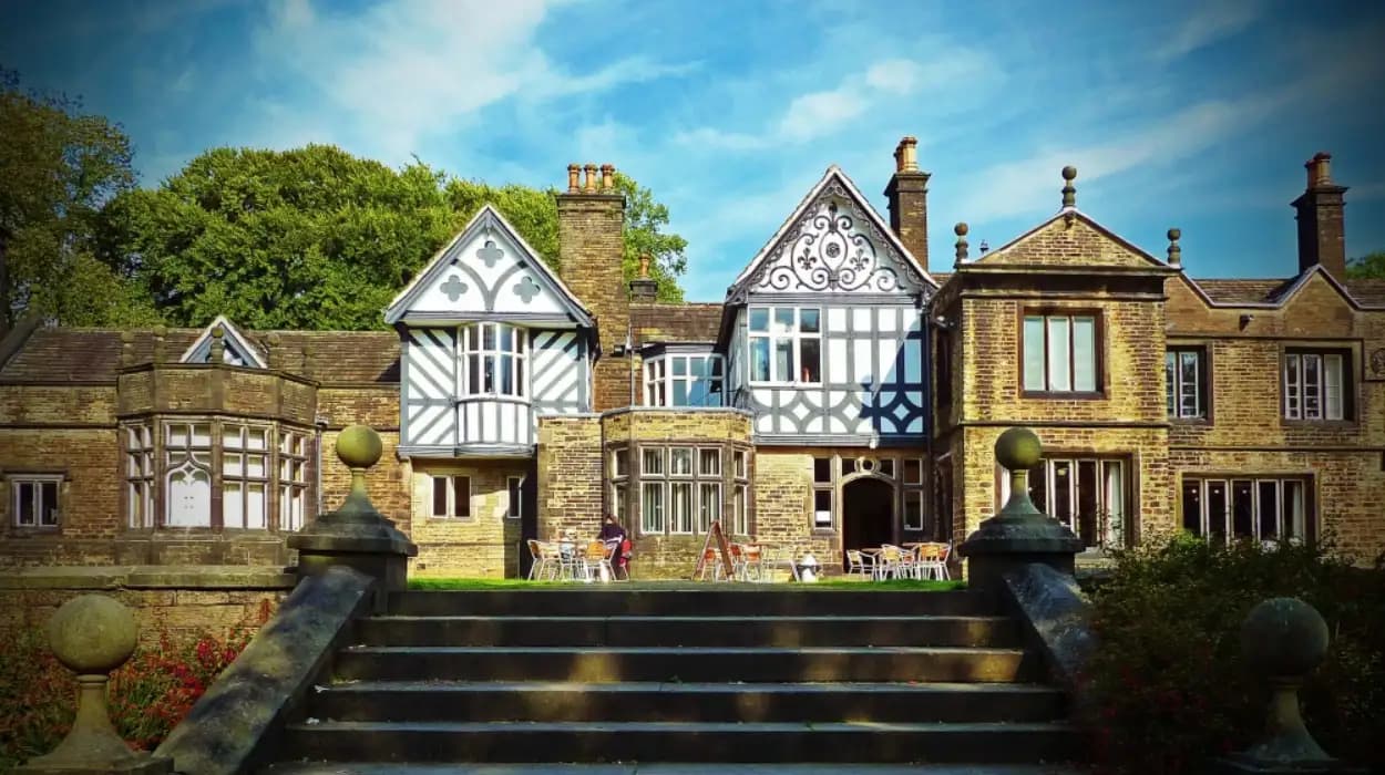
Smithills is one of Bolton’s most varied walking landscapes. The area combines medieval heritage, ancient and established woodland, farmland, wooded cloughs, streams, moorland, historic paths, and open upland views. Its walking routes connect the surviving landscape of Smithills Hall with the wider West Pennine Moors and the urban edge of Bolton.
The area is especially important because its paths are not simply recreational routes. They record centuries of land management, agriculture, industrial activity, public access campaigns, and conservation. The modern Smithills Estate covers about 686 hectares, or 1,700 acres, under the care of the Woodland Trust. It contains open countryside, woodland, streams, moorland, grassland, bog habitats, and historic features.
For walkers, this creates a distinctive network. A short woodland walk near Smithills Hall provides a different experience from a longer route towards Barrow Bridge, Winter Hill, or the upland landscape. The routes also demonstrate how Bolton's landscape changed from a medieval rural estate to an industrial district and then to a modern conservation landscape.
The following guide examines the best walking trails in Smithills through both their outdoor value and historical significance.
What makes Smithills one of Bolton’s best areas for walking?
Smithills offers a rare combination of woodland, moorland, farmland, streams, historic buildings, and public rights of way within one connected landscape. Walkers can experience gentle paths near Smithills Hall, wooded cloughs around Barrow Bridge, and demanding upland routes towards Winter Hill.
Smithills occupies an important position on the northern and western edge of Bolton. The landscape rises from the urban area towards open moorland. This geographical position creates significant variation in terrain over a relatively compact area.
The Smithills Estate is particularly important to modern outdoor recreation. The Woodland Trust describes its holdings as approximately 686 hectares, equivalent to 1,700 acres, of open countryside, streams, and woodland. The estate includes established and ancient woodland alongside moorland habitats.
Bolton Council's Rights of Way Improvement Plan identifies Smithills Country Park as one of the borough's two country parks. The council describes the area as having a network of concessionary footpaths and bridleways that connect with the definitive public footpath and restricted byway network. These routes provide walking and cycling opportunities within an environment that retains a rural character despite its proximity to the urban area.
This combination explains the area's popularity among different types of walkers. Families can use easier paths around the lower estate. Regular walkers can explore woodland tracks and cloughs. Experienced hillwalkers can continue towards the open moorland and higher ground.
The landscape also contains historical evidence. Smithills Hall stands at the centre of a historic estate whose written history extends back to the medieval period. The surrounding land preserves traces of agricultural management, transport, industrial use, and later conservation.
Walking in Smithills therefore provides access to both natural and cultural heritage. The route itself becomes part of the historical experience.
How did Smithills develop from a medieval estate into a modern walking landscape?
Smithills developed from a medieval manorial landscape into an agricultural estate, an industrially influenced upland environment, and finally a major conservation area. Its present walking network reflects these successive changes through historic paths, woodland, farmland, cloughs, and moorland access.
The historical foundation of Smithills is closely associated with Smithills Hall. Bolton's local museum service states that the first written records connected with the hall begin in 1335, when William Radcliffe obtained the manor from the Hulton family. The hall itself tells an approximately 800-year story of settlement and land ownership.
Historic England identifies Smithills Hall as a medieval hall house with origins in the early 14th century. The building was extended during later centuries, including the addition of an east wing in the 15th or early 16th century and a west wing in the late 16th century. The house was further remodelled in the 19th century.
The landscape around the hall developed alongside the building. Medieval estates depended on agricultural land, woodland resources, water, and controlled access routes. Paths connected the hall with farms, fields, woodland, and neighbouring settlements.
The Industrial Revolution introduced another layer of change. Bolton became a major centre of cotton manufacturing during the 18th and 19th centuries. The demand for fuel, timber, stone, water, and transport affected the wider landscape.
Smithills retained significant rural characteristics while industrial activity expanded around Bolton. Historic paths became practical connections between settlements, workplaces, farms, and upland areas. Some routes later became public walking paths.
The landscape also experienced changes in woodland composition. Parts of the estate contain ancient woodland, while other areas include later plantations and managed woodland. The present environment therefore represents different periods of woodland management rather than a single unchanged forest.
The modern walking landscape emerged from this long history. Historic estate roads, farm tracks, public rights of way, restricted byways, and newer access improvements now form an interconnected network.
Which walking trail around Smithills Hall is best for history and nature?
The walking routes around Smithills Hall provide the strongest introduction to the area's combined heritage and natural environment. Walkers encounter the Grade I listed medieval hall, landscaped grounds, woodland, historic approaches, agricultural land, and paths leading towards the wider Smithills Estate.
Smithills Hall is the natural starting point for understanding the local landscape. Historic England lists the building as Grade I, the highest category of statutory listing for buildings of exceptional interest. The hall stands within a registered historic park and garden landscape.
The hall's setting is significant because the surrounding landscape was shaped by centuries of estate management. Historic England records a site of approximately 48 hectares around the hall, with boundaries connected to Smithills Dean Road, an early 19th-century tram road, Raveden Clough, and neighbouring land.
The approach from Smithills Dean Road provides an important example of historic movement through the estate. The principal entrance includes a lodge and a drive leading towards the hall. Historic gate piers and a lime avenue contribute to the character of the historic approach.
A walk beginning near Smithills Hall allows visitors to observe how architecture and landscape interact. The medieval building represents long-term land ownership. The surrounding trees and grounds represent later landscape management. The paths connect these features with the wider countryside.
The route is suitable for walkers who prefer a shorter historical excursion. It also works as the first stage of a longer walk into the estate.
The area around the hall should be treated as a heritage landscape. Visitors should remain on permitted paths and respect signs, gates, wildlife habitats, and private areas.
To experience this historic landscape in person today, consult our comprehensive [History of Smithills Estate and Its Historic Landscape] for itineraries and visiting parameters.
What is the best woodland walking route in Smithills?
The woodland routes through Smithills Estate provide a varied walking experience with mature trees, ancient woodland, streams, steep-sided cloughs, and changing ground conditions. The network includes surfaced and unsurfaced paths, restricted byways, and wider tracks suitable for different walking abilities.
Smithills is particularly valuable for woodland walking because the estate contains both established and ancient woodland. Ancient woodland refers to woodland that has existed continuously on a site for centuries, even when individual trees have been replaced.
The Woodland Trust identifies ancient and established woodland within its Smithills holdings. The estate also contains wooded cloughs, which are narrow valleys shaped by water erosion and steep slopes. These cloughs create cooler and wetter local environments than exposed upland ground.
The woodland route network changes significantly with the weather. Wet conditions produce muddy sections on unsurfaced paths. Streams and drainage channels become more prominent after rainfall. Steep sections require greater care.
The Woodland Trust states that routes across Smithills include footpaths and restricted byways, with both surfaced and unsurfaced paths and wider tracks. Restricted byways are generally well surfaced and free from obstructions, although conditions vary across the wider estate.
The woodland also has ecological importance. Mature trees provide nesting and feeding habitats. Deadwood supports fungi and invertebrates. Damp woodland floors support mosses, ferns, and other shade-tolerant plants.
Tree species recorded across the broader Smithills landscape include oak, beech, sycamore, rowan, holly, and Scots pine. The mix reflects both native woodland characteristics and later planting traditions.
For nature lovers, the best approach is to walk slowly through the woodland sections rather than treating them solely as connections between destinations. Seasonal changes are visible in leaf cover, woodland flowers, fungi, and bird activity.
The woodland also provides a historical record. Its structure reflects centuries of land management, changing timber requirements, and conservation priorities.
What can walkers discover on the Barrow Bridge and Smithills woodland trails?
Barrow Bridge and its surrounding woodland form one of Smithills' most historically distinctive walking areas. The landscape contains steep cloughs, streams, woodland habitats, historic industrial connections, and the 63 Miners’ Steps, which record nineteenth-century working life.
Barrow Bridge lies within the wider Smithills Estate landscape. Its historic importance is linked to both industry and public access.
The Woodland Trust identifies Barrow Bridge as an area containing steep wooded cloughs and streams. The landscape also preserves historical features associated with local industrial workers. One of the best-known examples is the 63 Miners' Steps.
The steps were used by miners travelling to work on the moorlands during the 19th century. Their survival demonstrates how the landscape functioned as a working environment rather than simply as recreational countryside.
The route around Barrow Bridge therefore connects natural geography with industrial history. The steep terrain influenced the development of paths. Workers needed reliable routes between settlements and workplaces. The same physical landscape now supports recreational walking.
The woodland around the cloughs also has ecological significance. Streams create damp habitats. Steep slopes reduce intensive land use. Mature woodland provides cover for wildlife.
Walkers should expect uneven terrain in this area. Wet surfaces, exposed roots, stones, and steep sections require suitable footwear.
The Barrow Bridge area is particularly valuable for educational walking. A single route can demonstrate industrial archaeology, working-class history, woodland ecology, landscape management, and public access.
The 63 Miners' Steps also provide a direct connection between modern recreation and the social history of 19th-century Bolton. They show how people moved through the landscape before walking became primarily associated with leisure.
Where can experienced walkers find the best moorland adventure in Smithills?
Experienced walkers should head from the lower Smithills landscape towards the open moorland and higher ground around Winter Hill. These routes provide longer distances, steeper gradients, exposed terrain, broad views, and direct access to the wider West Pennine Moors.
The upland areas represent a major change from the sheltered woodland around Smithills Hall. Trees become less dominant. Open grassland, heather, peat-rich ground, bog habitats, and exposed rock become more prominent.
Winter Hill is one of the most recognisable upland landmarks in the Bolton area. The summit and surrounding moorland provide extensive views across the region.
The Woodland Trust describes panoramic views over Bolton from the Smithills landscape. Its estate also includes moorland and bog habitats, creating a transition from lowland woodland to open upland environments.
Walking towards higher ground requires greater preparation. Weather conditions change quickly on exposed moorland. Wind, rain, low cloud, and poor visibility affect navigation and comfort.
The terrain also contains wet ground. Bog habitats are environmentally sensitive and should not be crossed unnecessarily. Walkers should follow established paths and avoid damaging vegetation.
The upland walking experience is historically significant. The moors supported grazing, quarrying, mining, and other forms of economic activity. Historic access campaigns also demonstrate the social importance of these landscapes.
Smithills is therefore part of a wider history of public access to the countryside. Its moorland paths connect local heritage with the broader development of recreational walking in northern England.
For experienced walkers, the strongest routes are those that combine the lower estate with the higher moorland. This approach creates a clear geographical progression from medieval estate landscape through woodland and cloughs to open upland terrain.
Why are the 63 Miners’ Steps historically important to walkers?
The 63 Miners’ Steps preserve evidence of nineteenth-century industrial movement across Smithills. They were used by local miners travelling towards work on the moorlands, linking modern walking routes with the daily transport patterns of Bolton’s industrial communities.
The history of the 63 Miners' Steps demonstrates how ordinary infrastructure can become heritage.
During the 19th century, industrialisation transformed Bolton and its surrounding settlements. Mining formed part of the regional economy, while cotton manufacturing dominated the urban economy.
Workers travelled on foot because public transport was limited and employment sites were often separated from residential areas. Routes across hills and moorland became essential connections.
The steps at Smithills represent this practical movement. They were not originally constructed as a leisure attraction. Their purpose was connected to employment and daily life.
Today, walkers use the same landscape for recreation. This change in function illustrates a broader transformation in the relationship between people and the countryside.
The 63 Miners' Steps also demonstrate the importance of preserving minor historical features. Large buildings such as Smithills Hall receive formal heritage protection, but steps, tracks, walls, and paths can also provide important evidence.
These features help researchers reconstruct historical movement. They show where people travelled, how terrain affected routes, and how communities interacted with the landscape.
The steps therefore deserve attention within any historical walking itinerary in Smithills. They provide a direct physical connection between modern visitors and the working population of industrial Bolton.
What historical evidence can walkers find across Smithills Estate?
Smithills Estate contains historical evidence from medieval landholding, agricultural management, industrial activity, mining, transport, and public access campaigns. Surviving buildings, woodland, cloughs, tracks, miners’ steps, dry-stone walls, and moorland landmarks collectively document centuries of landscape change.
Smithills Hall provides the strongest architectural evidence. Its medieval origins, later extensions, and Victorian alterations show how one building adapted to changing social and economic conditions.
The surrounding landscape adds another historical layer. Agricultural fields indicate long-term rural land management. Woodland reflects timber production and estate management. Tracks demonstrate movement between settlements and workplaces.
Industrial activity left less obvious evidence. Mining routes and workers' paths survive in features such as the 63 Miners' Steps. Historic transport infrastructure also shaped the estate. The registered landscape around Smithills Hall includes the line of an early 19th-century tram road along its northern boundary.
Dry-stone walls also contribute to the landscape's historical character. These structures commonly marked boundaries, managed grazing, and divided agricultural land.
Two Lads, a pair of stone-built cairns on the wider estate, provide another landmark. The Woodland Trust describes them as an iconic feature with a history surrounded by local folklore. Their exact origins remain part of the historical interpretation of the upland landscape.
The estate also has a significant public-access history. The Woodland Trust records that 10,000 people gathered on the Smithills moors in 1896 to demand access rights. This occurred more than 30 years before the 1932 Kinder Scout mass trespass, which became a major event in the history of public access to open countryside.
This history gives Smithills walking routes wider significance. Modern access exists within a landscape shaped by centuries of work and decades of campaigning.
How has conservation changed walking in Smithills?
Modern conservation has expanded the role of Smithills from historic estate to major ecological landscape. Woodland restoration, improved paths, habitat management, and public-access projects now protect biodiversity while maintaining opportunities for walking across woodland, countryside, and moorland.
The Woodland Trust acquired Smithills Estate as its largest English site. The organisation now manages approximately 686 hectares, or 1,700 acres, of countryside, woodland, and streams.
Conservation work addresses the effects of centuries of industrial and land-use pressure. The estate contains habitats that require different management approaches. Ancient woodland requires protection from inappropriate disturbance. Moorland requires careful management of vegetation and access. Wet habitats require protection from erosion.
Public access is also part of the conservation strategy. The Woodland Trust reports that it has installed 1.6 kilometres, or approximately one mile, of flagged moorland paths and continues to improve access across the estate.
Path improvements have practical benefits. They concentrate foot traffic on durable surfaces. They reduce erosion. They improve accessibility. They also help walkers navigate sensitive environments without creating unnecessary informal paths.
The modern approach demonstrates that conservation and recreation operate together. The objective is not to exclude people from the landscape. It is to manage access responsibly.
The historical significance is equally important. The 1896 access campaign demonstrates that public access has long been central to the identity of Smithills. Modern path improvements continue this tradition within a conservation framework.
What wildlife and habitats can walkers see on Smithills trails?
Smithills supports a varied mixture of woodland, grassland, moorland, bog, streams, and clough habitats. Walkers can encounter woodland birds, insects, fungi, ferns, mosses, upland vegetation, and moorland species such as red grouse across different parts of the estate.
Habitat diversity is one of Smithills' main ecological strengths. The landscape changes from enclosed woodland to open moorland across relatively short distances.
Wooded cloughs provide sheltered environments. Streams maintain damp conditions. Ancient and established woodland support mature trees and deadwood habitats. Open grassland provides different conditions for insects and ground-feeding birds.
The Woodland Trust specifically identifies red grouse among the birds associated with the moorland landscape. It also highlights common lizards within the estate's wildlife.
Walkers should understand that wildlife observation depends on habitat and season. Woodland birds are easier to detect by sound when foliage is dense. Moorland birds are associated with open upland habitats. Reptiles use sunny areas where ground temperatures increase.
The estate's wet conditions also support bryophytes, including mosses and liverworts. These plants are important indicators of woodland microclimates because they depend on moisture and humidity.
Conservation research in the wider Smithills landscape has also examined whether some areas contain characteristics associated with temperate rainforest habitats. Such classification requires scientific assessment of environmental indicators and habitat condition. It should not be treated as an established designation across the whole estate.
For nature lovers, the key value is habitat variety. A single walk can cross several ecological environments. This creates opportunities to observe how altitude, moisture, soil, and woodland cover influence biodiversity.
Responsible walking remains essential. Dogs should be controlled where signs require it. Wildlife should not be disturbed. Walkers should remain on established routes in sensitive areas.
Which Smithills walking route is best for families and casual walkers?
Families and casual walkers should begin with the lower, more accessible paths around Smithills Hall and the estate's established track network. These areas offer shorter walking options, clearer surfaces, historical landmarks, and opportunities to experience woodland without committing to exposed upland terrain.
Smithills provides different levels of walking difficulty because its network includes surfaced and unsurfaced routes. The Woodland Trust states that paths include footpaths, restricted byways, and wider tracks, while Bolton Council identifies extensive paths, tracks, cycling routes, and horse-riding routes around Smithills Hall.
The lower landscape is generally the logical starting point for visitors who want a shorter outing. Smithills Hall provides a clear destination and a strong historical focus.
Families can also use the woodland environment as an educational resource. Children can learn about tree species, woodland habitats, local history, and industrial heritage during one visit.
The route choice should reflect weather conditions. A path that is comfortable during dry weather becomes more challenging after heavy rainfall.
Visitors should also distinguish between a public right of way and private land. Not every visible track is automatically open to public access. Official signage and mapped rights of way provide the correct basis for route planning.
Smithills Open Farm is another attraction within the wider Smithills area, but it operates as a separate visitor destination from the open walking network. Walkers planning a family day should distinguish between the estate's public countryside paths and commercial attractions.
The strongest family walking experience combines a manageable route with one historical feature. Smithills Hall, the woodland, or the lower estate paths provide clear points of interest without requiring a full hill walk.
How can walkers connect Smithills trails with the wider West Pennine Moors?
Smithills functions as a gateway between Bolton's urban edge and the wider West Pennine Moors. Longer walkers can use the estate's network to move from historic woodland and cloughs towards open upland terrain, including routes associated with Winter Hill and neighbouring landscapes.
The geographical position of Smithills explains its importance as a walking hub. The area sits between the built-up environment of Bolton and the open landscapes of the West Pennine Moors.
This creates a natural progression for longer walks. A route can begin near Smithills Hall, pass through woodland, cross cloughs, reach open countryside, and continue towards higher ground.
The wider landscape contains significant viewpoints. Winter Hill is particularly prominent, with panoramic views extending across Greater Manchester and Lancashire on clear days.
The transition also demonstrates the relationship between urban development and rural conservation. Bolton's industrial growth transformed the valley and townscape below. The uplands remained comparatively open, although they experienced mining, grazing, forestry, and recreational pressures.
Walkers should plan longer routes carefully. The estate contains multiple path types and route options. Distance increases quickly when paths are combined into circular walks.
Navigation is especially important in poor weather. Moorland paths can become difficult to identify in low visibility. Digital mapping and an appropriate physical map provide useful support.
Long-distance walking also increases the importance of responsible access. Gates should be closed where required. Livestock should not be disturbed. Sensitive habitats should be avoided where signs indicate restrictions.
The connection between Smithills and the wider moors makes the area valuable for outdoor adventure. It allows walkers to experience several landscape types within one continuous journey.
Why does Smithills remain important for Bolton’s future heritage?
Smithills remains important because it preserves an unusually complete relationship between historic architecture, working landscapes, public access, biodiversity, and modern conservation. Its future value depends on protecting heritage features, improving responsible access, restoring habitats, and maintaining the connection between people and countryside.
Smithills demonstrates how landscapes accumulate historical meaning. The medieval origins of Smithills Hall form the architectural foundation. Agricultural land records rural production. Woodland records centuries of management. Miners' paths document industrial employment. Access campaigns record social history. Conservation work represents the modern environmental era.
Few walking landscapes provide such a clear sequence.
The future of Smithills therefore depends on balancing several objectives. Historic structures require conservation. Ancient woodland requires protection. Moorland paths require maintenance. Public access requires careful management. Wildlife habitats require long-term monitoring.
The Woodland Trust's ownership and conservation programme provides a significant framework for this work. Its investment in access improvements demonstrates that public recreation remains part of the estate's future.
The 1896 access campaign also remains historically relevant. It shows that public access to Smithills has a long tradition. Modern walkers benefit from a landscape that earlier generations fought to access.
The historical value of Smithills extends beyond Smithills Hall. The estate should be understood as an interconnected cultural landscape. Its paths, trees, fields, streams, cloughs, moorland, walls, and industrial remnants collectively explain the area's development.
For history enthusiasts, Smithills provides evidence of medieval landholding and later estate management. For nature lovers, it provides diverse habitats. For outdoor adventure seekers, it offers woodland paths and upland terrain. For educators, it provides a practical field study environment.
Its long-term significance lies in the combination of these functions.
The best walking trails in Smithills are therefore not defined by one route alone. The strongest experience comes from understanding how different paths fit into the larger landscape. The woodland route explains ecological continuity. The Barrow Bridge paths reveal industrial history. The 63 Miners' Steps preserve working-class heritage. Smithills Hall anchors the medieval and architectural story. The moorland routes connect the estate with the wider West Pennine landscape.
Together, these routes create a historically rich outdoor destination within Bolton. The landscape remains both a record of the past and an active part of the borough's environmental future.
FAQS
What are the best walking trails in Smithills?
The best walking routes include trails around Smithills Hall, Smithills Estate, Barrow Bridge, the 63 Miners' Steps, and routes towards Winter Hill. These trails offer a combination of woodland, historic landmarks, streams, moorland, wildlife, and scenic countryside.