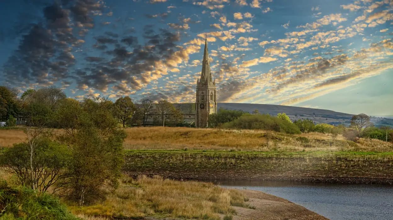
Belmont is a hilltop village and rural settlement in the northern part of the Bolton area, positioned within the wider West Pennine landscape. Its scenic character comes from elevated roads, open moorland, reservoirs, wooded valleys, stone buildings, and long-distance views towards Winter Hill and surrounding Lancashire and Greater Manchester landscapes.
For visitors, photographers, walkers, local historians, and researchers, Belmont offers a landscape where natural scenery and human history remain closely connected. The village sits near the edge of the West Pennine Moors, a landscape shaped by agriculture, quarrying, water management, transport, religious development, and the growth of nearby industrial settlements.
The best scenic views across Belmont are not concentrated at one formal viewpoint. They are distributed across elevated lanes, open countryside, reservoir surroundings, church approaches, and nearby moorland routes. The character of each view changes throughout the year as vegetation, weather, daylight, and land use change.
Belmont's position also explains why the area has long attracted attention as a landscape of visual importance. Bolton Council's landscape studies describe the wider borough as a transition between urban valleys and the higher West Pennine Moors, while the council's current greenspace strategy identifies Winter Hill as reaching 444 metres above sea level.
Where are the best scenic views in Belmont?
The best scenic views in Belmont come from elevated village roads, open countryside near the West Pennine Moors, approaches around St Peter's Church, and nearby reservoir landscapes, where visitors see hills, valleys, woodland, stone buildings, and changing seasonal vegetation.
Belmont's strongest viewpoints are connected to its topography. The settlement occupies elevated ground north of Bolton, giving selected roads and footpaths clear sightlines across lower valleys and towards higher moorland.
The most distinctive views occur where built-up areas meet open countryside. These transition zones provide visual contrast between traditional stone architecture and expansive landscapes. The surrounding countryside includes pasture, woodland, reservoirs, rough grassland, and moorland.
St Peter's Church provides an important architectural reference point within the landscape. The Grade II listed church stands on Church Road and dates principally from the mid-19th century. Historic England records the building as dating from 1849–50 and attributes its design to architect J. E. Gregan. It is constructed in sandstone with a slate roof and features an Early English architectural style.
The church is also significant because its building material connects Belmont's architecture directly with local geology. Historic England's research on Lancashire building stones identifies Ousel Nest Grit as a Pennine Lower Coal Measures sandstone found around Turton, Eccleston, and Horwich. St Peter's Church at Belmont is constructed from this stone.
This combination of historic architecture and elevated countryside makes Belmont particularly valuable for landscape photography. A single walk can include a listed church, traditional buildings, wooded slopes, open fields, and distant upland horizons.
The wider administrative history is also relevant. Bolton Council records that part of Sharples, including Belmont, formed part of Turton Urban District after the reorganisation of local government in 1898. The modern borough of Bolton was created in 1974. This history explains why Belmont's identity remains closely connected to both the historic Turton area and the wider Bolton landscape.
Why does Belmont have such distinctive panoramic views?
Belmont has distinctive panoramic views because it occupies elevated land beside the West Pennine Moors, where valleys, reservoirs, woodland, pasture, and urban settlements create long sightlines across a varied landscape shaped by geology and centuries of human activity.
The geography of Belmont is the foundation of its scenic value. The area lies within the northern part of the Bolton landscape, where the terrain rises from urban and semi-rural valleys towards the West Pennine Moors.
Bolton's landscape character is defined by narrow valleys cutting through upland terrain. These valleys contain fast-flowing watercourses, wooded cloughs, open slopes, and historic settlements. The landscape appraisal produced for Bolton Council identifies these valleys as a distinctive feature of the South Pennine landscape and notes their proximity to densely settled urban areas.
This geography produces several types of scenic viewpoint.
Elevated village viewpoints
Higher roads provide views over rooftops and countryside. These locations are particularly valuable because they demonstrate how Belmont developed at the meeting point between settlement and open land.
Valley viewpoints
Lower areas reveal the structure of the landscape. Valleys appear as corridors of woodland and pasture, often framed by higher slopes.
Moorland viewpoints
Open upland locations provide the longest views. On clear days, the landscape extends beyond the immediate village towards the broader Pennine region.
Reservoir viewpoints
Water adds a reflective surface and creates a strong visual contrast with hills, woodland, and stone infrastructure. Reservoirs in the wider area are products of industrial-era water management and therefore combine environmental and historical significance.
The scenic experience changes because each geographical setting reveals a different relationship between land and settlement. Elevated ground shows the wider landscape, valleys reveal topography, and reservoirs demonstrate how people have modified the environment.
Which Belmont views are best in spring?
Spring is one of the strongest seasons for Belmont's scenic views because longer daylight, fresh vegetation, flowering plants, and clearer contrasts between green fields and darker upland terrain create detailed landscapes around village roads, woodland edges, reservoirs, and open countryside.
Spring transforms the visual character of Belmont. Trees regain foliage, grassland becomes greener, and woodland edges develop new vegetation. The combination of fresh growth and longer daylight produces strong conditions for landscape observation.
The best spring views are found where open fields meet woodland. These locations show the seasonal transition clearly. Bare branches gradually become covered with leaves, while roadside vegetation develops around paths and boundaries.
St Peter's Church is particularly effective as a spring landscape subject because the stone building provides a fixed historic structure against changing vegetation. The church's Ousel Nest Grit construction gives it a strong connection with the local geological landscape.
Spring also provides opportunities to examine the relationship between Belmont's built environment and its surrounding countryside. Traditional stone structures appear within a landscape that becomes progressively greener as the season advances.
The reservoir landscapes around the wider Belmont and Turton area also benefit from spring conditions. Water levels, woodland, and fresh vegetation create layered views that combine natural and engineered features.
For historians, spring is also useful for studying landscape continuity. Field boundaries, lanes, churches, and settlement patterns remain visible beneath seasonal growth. These features demonstrate how modern Belmont retains elements of its historic rural structure.
Where should you look for summer views around Belmont?
Summer provides Belmont's fullest green landscapes, with mature trees, dense vegetation, open pasture, and long daylight creating strong views from elevated lanes, reservoir surroundings, countryside paths, and higher ground overlooking the West Pennine landscape.
Summer offers the greatest amount of daylight for exploring Belmont's scenic surroundings. The landscape becomes visually dense, with mature tree canopies, green fields, hedgerows, and vegetation around watercourses.
The strongest summer views are found at locations where vegetation does not completely block the horizon. Elevated roads and open fields therefore provide better long-distance perspectives than enclosed woodland paths.
Summer also highlights the contrast between Belmont's stone architecture and its natural surroundings. Historic buildings remain visually prominent because their masonry provides a permanent structure against seasonal greenery.
The wider West Pennine landscape is particularly important during summer. Bolton Council's biodiversity reporting identifies the borough as containing diverse habitats, including upland oak woods, blanket bog, and moorland environments. The borough also has 17 Local Nature Reserves and more than 70 Sites of Biological Importance, demonstrating the wider ecological importance of the landscape surrounding settlements such as Belmont.
Summer views also reveal the consequences of historic land management. Pastures, reservoirs, woodland plantations, stone walls, and roads represent different stages of human interaction with the landscape.
For educators and students, these views provide a practical way to study geography and history together. A single landscape can demonstrate geology, agricultural land use, industrial water management, settlement expansion, and modern conservation.
Why is autumn a special season for Belmont's scenic landscapes?
Autumn gives Belmont some of its most visually varied scenery because woodland changes colour, lower sunlight creates stronger shadows, mist develops around valleys, and historic stone buildings contrast with seasonal foliage across the surrounding West Pennine landscape.
Autumn is especially valuable for visitors interested in landscape detail. The colour of deciduous woodland changes progressively, producing different appearances across the season.
Early autumn retains much of summer's green vegetation. Later autumn introduces gold, brown, orange, and red tones into woodland. This creates strong visual contrasts around historic buildings, roads, reservoirs, and valley slopes.
The changing position of the sun also affects views. Lower autumn sunlight creates longer shadows across fields and woodland. Stone buildings can appear more visually defined because of stronger contrasts between illuminated and shaded surfaces.
Mist is another important feature of autumn landscapes. When it forms in lower valleys, elevated areas around Belmont can provide views across a layered landscape of woodland, fields, and distant hills.
The historic importance of the landscape becomes particularly clear during autumn. Belmont's visual identity is not simply the result of natural scenery. It reflects centuries of land use, including farming, quarrying, settlement construction, and water management.
St Peter's Church remains one of the clearest examples of this relationship between architecture and landscape. Its Grade II listing recognises its architectural importance, while its sandstone construction connects it with the geological resources of the wider region.
Autumn therefore provides an effective season for heritage photography and landscape research. The combination of historic structures and changing vegetation reveals how the visual character of Belmont has evolved without losing its underlying geographical identity.
Which Belmont viewpoints are best during winter?
Winter offers the clearest structural views across Belmont because leafless trees open sightlines, lower vegetation exposes landscape contours, and cold weather often reveals the relationship between elevated village ground, valleys, reservoirs, and distant West Pennine hills.
Winter changes the visual priorities of Belmont. Instead of dense vegetation, the landscape becomes more open and structural.
Leafless trees reveal buildings and landforms that summer foliage hides. Field boundaries become easier to identify, while slopes and valleys appear more clearly defined.
Winter is particularly useful for studying the historic geography of the village. Roads, walls, churches, farms, and settlement clusters become more visible as vegetation recedes.
Higher ground remains the most valuable location for long-distance views. Winter daylight is shorter, but clear atmospheric conditions can produce sharp views across the surrounding countryside.
Snow is less predictable and should not be treated as a permanent seasonal feature. When it occurs, however, the contrast between white upland surfaces and darker stone buildings produces a distinctive visual record.
Winter also highlights the relationship between Belmont and the wider West Pennine Moors. Bolton Council describes the borough as extending from relatively flat southern land towards high moorland in the north, with Winter Hill reaching 444 metres above sea level. This elevation difference explains the strong visual relationship between lower settlements and upland horizons.
For landscape historians, winter is valuable because it exposes the underlying structure of the countryside. The absence of dense foliage makes historic field patterns and settlement boundaries easier to interpret.
How does St Peter's Church contribute to Belmont's scenic views?
St Peter's Church contributes to Belmont's scenic character by providing a prominent historic landmark within the village landscape, combining 19th-century Gothic Revival architecture, locally sourced sandstone, surrounding countryside, and a long-established religious presence.
St Peter's Church is an important architectural landmark in Belmont. Historic England lists it at Grade II and records its construction in 1849–50 under architect J. E. Gregan. Its design follows the Early English style and uses sandstone with a slate roof.
The church's position is important for understanding Belmont's visual identity. Historic religious buildings often became focal points within settlements because their towers and roofs provided recognisable landmarks.
The building also demonstrates the importance of local materials. Historic England identifies Ousel Nest Grit as a regional sandstone associated with the Pennine Lower Coal Measures. The stone was quarried around parts of the wider Bolton and Turton region and used in local buildings.
This creates a direct connection between geology, architecture, and landscape.
Visitors examining views around the church can therefore interpret more than visual scenery. The stone reflects the area's geological resources, the building reflects 19th-century religious expansion, and its location reflects the development of Belmont as a settled community.
The church also has value for genealogical research. Historic parish buildings and their associated records can provide important evidence for family history, including baptisms, marriages, burials, and community relationships. Researchers tracing local lineages should consult relevant archival collections rather than relying solely on the physical landscape.
How are Belmont's reservoirs connected to its scenic heritage?
Belmont's reservoir landscapes form part of a wider West Pennine water-management system created to support growing populations and industrial communities, combining engineered dams, open water, woodland, valleys, and upland scenery within a historically modified environment.
Reservoirs are an essential part of the scenic landscape surrounding Belmont and neighbouring Turton communities. They are not purely natural features. Their creation reflects the growth of industrial Lancashire and the increasing demand for reliable water supplies.
The construction of reservoirs transformed valleys into large water bodies. This changed local scenery while creating new habitats and recreational landscapes.
The visual character of reservoir landscapes comes from the combination of water and surrounding topography. Dams create straight or engineered lines, while woodland and hills provide irregular natural forms.
The wider Bolton area contains reservoirs under different ownership. Bolton Council states that its own larger reservoirs include Doffcocker and Mortfield Lodges, while other large reservoirs are owned and maintained by private organisations or United Utilities. The council also notes that reservoir safety is governed by the Reservoirs Act for qualifying structures.
The Jumbles, Entwistle, and Wayoh reservoir landscapes are particularly relevant to the broader northern Bolton and Turton scenic context, although visitors should distinguish between Belmont itself and neighbouring areas.
This distinction is important for accurate historical writing. Bolton Council's own information notes that Belmont, Turton, Edgworth, and the Entwistle and Wayoh reservoirs are not within Bolton Council's administrative area, despite their close geographical and cultural relationships with the wider Bolton landscape.
For visitors exploring the region, this interconnected landscape demonstrates how administrative boundaries do not always correspond with historical or geographical identity.
To experience this historic landscape in person today, consult our comprehensive [Why Belmont Became One of Bolton's Most Scenic Villages] for itineraries and visiting parameters.
What historical features can visitors see alongside Belmont's scenic views?
Belmont's scenic landscapes contain historic churches, stone buildings, roads, field boundaries, reservoirs, and upland routes that demonstrate the area's transition from rural settlement to a connected regional landscape influenced by agriculture, industry, transport, religion, and modern conservation.
Belmont's historic landscape is visible through surviving structures and land patterns.
The first major feature is traditional stone architecture. Local sandstone reflects the area's geological resources and historic construction traditions. Buildings constructed from regional stone form an important part of the village's visual identity.
The second feature is St Peter's Church. Its mid-19th-century construction reflects population growth and religious development during the Victorian period. Its Grade II listing provides formal recognition of its architectural importance.
The third feature is the road network. Historic lanes connect the settlement with surrounding rural areas and provide evidence of how communities interacted with neighbouring farms, villages, and market centres.
The fourth feature is the wider water landscape. Reservoirs demonstrate the technological and administrative response to growing urban and industrial populations.
The fifth feature is the open moorland. The West Pennine Moors preserve an important ecological and cultural landscape that continues to influence the identity of northern Bolton.
These features should be understood together rather than separately. Belmont's scenery is the visible result of interactions between natural geology and human activity.
The historical process began with rural land use and settlement. It continued through agricultural development, quarrying, religious construction, industrial-era water infrastructure, and modern conservation.
The result is a layered landscape where different historical periods remain visible within the same view.
How can visitors compare Belmont's scenic views throughout the year?
Visitors can compare Belmont's seasonal scenery by returning to the same elevated roads, church surroundings, reservoir landscapes, and countryside viewpoints during spring, summer, autumn, and winter, recording changes in vegetation, daylight, visibility, weather, and landscape structure.
A systematic approach produces the most useful seasonal comparison.
Spring reveals new vegetation and flowering growth. Summer shows mature greenery and extended daylight. Autumn introduces changing woodland colours and lower sunlight. Winter exposes landforms, buildings, and field patterns hidden by foliage.
The same viewpoint can therefore produce four distinct visual records without the landscape itself changing fundamentally.
This method is useful for educators and students studying environmental change. It also supports heritage research because repeated photographs document how historic structures remain within changing natural surroundings.
Photographers can use fixed locations to compare light conditions. Local historians can examine changes in vegetation and land use. Conservation researchers can record landscape management.
Seasonal comparison also demonstrates the importance of preserving viewpoints. If trees, buildings, or infrastructure block historically significant sightlines, the relationship between the village and its surrounding landscape can become less visible.
Bolton Council's conservation policy recognises the importance of protecting areas with outstanding historic or architectural interest. The council currently identifies 26 conservation areas across the borough, ranging from urban areas to small rural villages in the West Pennine Moors.
Although not every scenic viewpoint has formal conservation status, the principle remains relevant. Landscape character depends on the interaction of buildings, vegetation, open land, and views.
Why are Belmont's scenic views important for heritage preservation?
Belmont's scenic views are important for heritage preservation because they connect historic buildings with their geographical setting, demonstrate centuries of land use, preserve local identity, and provide evidence of how rural communities developed beside the expanding industrial towns of Lancashire.
Heritage preservation is not limited to individual buildings. The setting surrounding a historic structure often contributes to its significance.
St Peter's Church provides a clear example. Its architectural importance is formally recognised, but its relationship with Belmont's countryside also contributes to the building's visual identity.
The same principle applies to traditional stone buildings, historic roads, field boundaries, and reservoir landscapes.
Landscape preservation also supports local historical research. Researchers studying family history can use maps, church locations, roads, farms, and settlement patterns to understand where historical communities lived and worked.
The visual relationship between Belmont and the West Pennine Moors therefore has academic value. It provides evidence of settlement geography and changing land use.
Modern environmental policy adds another dimension. Bolton Council's biodiversity reporting identifies significant habitats and ecological assets across the borough, including upland oak woods, blanket bog, rare plants, specialist birds, and protected sites.
Preserving scenic views therefore supports several objectives at once. It protects landscape character, historic setting, ecological value, and community identity.
The long-term relevance of Belmont's scenery depends on responsible land management. Development, vegetation growth, infrastructure, and climate pressures can alter views over time.
Documenting the landscape today creates a historical record for future generations.
What is the best way to explore Belmont's scenic views in every season?
The best approach is to combine elevated village viewpoints, historic landmarks, open countryside, and nearby reservoir landscapes across different seasons, while checking land access, weather, daylight, and local conditions before beginning each visit.
Belmont is best understood as a landscape rather than a single viewpoint. Visitors should therefore explore different geographical settings and compare them over time.
Start with the village and its historic architecture. Continue towards open countryside and elevated ground. Extend exploration towards the wider Turton and West Pennine landscape where public access allows.
The most valuable experiences combine scenery with historical interpretation. A view across fields becomes more meaningful when visitors understand the agricultural landscape behind it. A reservoir becomes historically significant when its role in water management is understood. A stone church becomes more informative when its architecture and geological materials are considered together.
Seasonal timing also matters. Spring is strongest for fresh vegetation. Summer provides long daylight. Autumn offers changing foliage and atmospheric conditions. Winter provides the clearest structural views.
Weather conditions should always be considered before walking in exposed upland areas. Routes can become wet and slippery, while visibility can change quickly.
Visitors should also respect private land, follow public rights of way, and avoid entering restricted areas. Reservoir infrastructure requires particular care because operational sites can contain hazards.
Belmont's scenic importance ultimately comes from its combination of landscape and history. The village stands within a wider geographical system shaped by geology, agriculture, religion, water management, settlement, and conservation.
Its views therefore represent more than attractive scenery. They provide a visual record of regional history.
From the sandstone of St Peter's Church to the open slopes of the West Pennine landscape, Belmont demonstrates how natural and human histories remain connected. Its elevated position creates long views, while its historic buildings provide fixed reference points within a changing environment.
Across spring, summer, autumn, and winter, the same landscape reveals different details. Vegetation changes, daylight shifts, and atmospheric conditions alter the appearance of the countryside, but the underlying geography remains.
That continuity gives Belmont lasting value for visitors, historians, photographers, educators, and heritage researchers. The best scenic views are therefore found not at one single location, but across the interconnected landscape of the village, its countryside, and the wider West Pennine setting.
Belmont's scenic heritage remains relevant because it records the relationship between people and place. Protecting those views preserves not only visual beauty, but also the historical context that allows future generations to understand how this distinctive part of the Bolton region developed.
FAQS
What are the best scenic views in Belmont?
The best scenic views in Belmont are found around elevated village roads, open countryside, St Peter's Church, and nearby West Pennine landscapes. These locations provide views of rolling hills, valleys, woodland, reservoirs, traditional stone buildings, and distant upland scenery.