Belmont became one of Bolton’s most scenic villages through the combined influence of its elevated West Pennine setting, historic farming landscape, local stone architecture, reservoirs, woodland, and proximity to Winter Hill. Its appearance developed gradually as agriculture, water engineering, industry, transport, and Victorian settlement reshaped the landscape.
The village stands north of Bolton within the West Pennine Moors, a landscape of upland hills, valleys, reservoirs, streams, pasture, and moorland. Its visual character differs from the dense urban form associated with central Bolton. Belmont retains a stronger relationship with open countryside and elevated terrain.
The scenic identity of Belmont is therefore historical as well as geographical. The village did not become attractive solely because of modern tourism or recreational walking. Its landscape reflects centuries of land use and the infrastructure created during Bolton’s industrial expansion.
Belmont’s development also demonstrates the relationship between an industrial town and its rural hinterland. Bolton became a major Lancashire cotton centre during the Industrial Revolution. The expanding population required reliable water supplies, transport connections, housing, employment, and agricultural resources. Belmont occupied an important position within this wider system.
The result is a settlement where natural and built heritage remain closely connected. Historic cottages stand near reservoirs. A Victorian parish church forms a landmark within the village. Roads climb through an elevated landscape. Open views extend towards the surrounding hills. These elements explain why Belmont is widely recognised as one of the most scenic settlements associated with Bolton.
Why is Belmont’s landscape naturally scenic?
Belmont’s natural scenery comes from its elevated position within the West Pennine landscape, where hills, valleys, reservoirs, streams, woodland, pasture, and moorland create varied views. The village’s position beyond Bolton’s dense urban core preserves a strong visual connection with open countryside.
Belmont lies within the northern part of the Bolton metropolitan area, close to the West Pennine Moors. The wider landscape is characterised by upland terrain rather than the flatter urban environment found further south.
Elevation is one of the most important factors in Belmont’s scenic character. Roads and settlements on higher ground provide broader views across valleys and towards surrounding hills. Winter Hill is a particularly important geographical landmark in the wider landscape.
The West Pennine landscape developed through geological and climatic processes over long periods. Glacial activity helped shape valleys and exposed upland terrain. Later human activity transformed this natural environment through agriculture, quarrying, water management, settlement, and industry.
Belmont therefore represents a cultural landscape. A cultural landscape is an environment shaped by continuous interaction between people and natural conditions. In Belmont, stone buildings, field boundaries, reservoirs, roads, churches, and industrial sites exist within a naturally varied upland setting.
The village's scenery also benefits from visual contrast. Open moorland appears alongside enclosed fields. Woodland occupies sheltered slopes. Reservoir water creates reflective surfaces within the hills. Stone buildings introduce architectural detail without dominating the surrounding landscape.
This combination gives Belmont a distinctive visual structure. The landscape changes according to elevation, weather, season, and viewpoint. However, the fundamental geographical characteristics remain consistent.
Bolton Council recognises the importance of conservation areas in protecting historic and architectural interest across the borough. Its conservation framework covers both urban locations and rural villages within the West Pennine Moors. This approach reflects the importance of preserving the relationship between historic settlement and natural environment.
How did Belmont develop before the Industrial Revolution?
Before industrialisation, Belmont developed as a rural settlement connected to farming, landholding, local roads, and upland resources. Its earlier landscape established the agricultural fields, routes, stone buildings, and settlement pattern that later industrial and Victorian development incorporated.
The history of Belmont extends beyond the nineteenth century. The wider Bolton area contains evidence of prehistoric activity, including Bronze Age remains elsewhere on the West Pennine landscape. Archaeological finds associated with the wider Winter Hill region include prehistoric artefacts and burial monuments.
Belmont itself was historically associated with the township of Sharples within the ancient parish of Bolton-le-Moors. The name Hordern is recorded as an earlier name for the settlement before the nineteenth-century development of Belmont.
The medieval and early modern landscape was predominantly rural. Land was divided between farms, fields, tracks, and common or upland areas. Agriculture provided the basic economic structure for local communities.
The physical geography influenced this development. Higher ground supported grazing and rough pasture. Lower valleys provided water and more sheltered conditions. Streams and springs were important for farming and later industrial processes.
Local stone also influenced architecture. Buildings constructed from stone fitted naturally into the upland landscape. Their materials came from the geological environment around them, creating a close visual relationship between settlement and countryside.
This early rural structure is important because later scenic qualities often depend on historic continuity. The roads, field patterns, farmsteads, and building traditions established before large-scale industrialisation remained visible after Belmont expanded.
The transition from rural settlement to industrial community was gradual. Belmont did not lose all of its agricultural character when factories and reservoirs appeared. Instead, new economic functions were layered onto an existing landscape.
That process created the mixed character visible today. Belmont contains evidence of rural life, Victorian religious architecture, industrial development, water infrastructure, and modern residential growth.
When did Belmont become connected with Bolton’s industrial expansion?
Belmont became increasingly connected with Bolton’s industrial expansion during the nineteenth century, when population growth increased demand for water, employment, transport, and industrial resources. The village developed alongside mills, works, reservoirs, and supporting infrastructure while retaining its upland rural setting.
The Industrial Revolution transformed Bolton during the eighteenth and nineteenth centuries. Cotton spinning and textile manufacturing expanded rapidly. The town became one of Lancashire’s major industrial centres.
Industrial growth created pressure on natural resources. Water became especially important. Textile manufacturing required reliable supplies for industrial processes, while the growing urban population required safe domestic water.
Belmont’s location made it significant within this wider system. The village occupied a landscape containing streams, reservoirs, and elevated catchment areas. Water engineering became one of the most important forces shaping its history.
The Belmont Reservoir was built in 1824. Historical accounts of Bolton’s water supply identify the reservoir as part of the nineteenth-century development of the town's water infrastructure. The expansion of water provision reflected Bolton’s rapid population growth and industrial demands.
The reservoir changed the landscape permanently. Water infrastructure introduced a large engineered feature into the upland environment. The resulting combination of water, hills, stone structures, and vegetation contributed to the visual character associated with Belmont.
The reservoir also demonstrates how industrial development could create landscapes that later became valued for their scenic qualities. Its original purpose was practical. Its long-term visual significance became broader.
Belmont's industrial history extended beyond water. Historical descriptions record cotton mills, a dye works, a print works, and a paper works within the wider settlement and valley environment. These enterprises connected Belmont to the industrial economy of Bolton and Lancashire.
The industrial landscape was therefore not separate from the scenic landscape. Factories occupied valleys. Watercourses supported production. Stone buildings reflected local materials. Roads connected workplaces and settlements. Reservoirs supplied water.
This combination explains why Belmont should not be described simply as an untouched rural village. Its present appearance is the product of interaction between industrialisation and the countryside.
How did Belmont Reservoir change the village’s appearance?
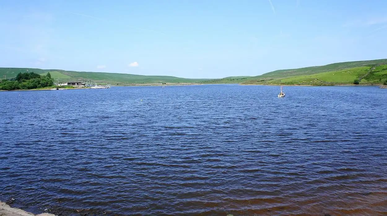
Belmont Reservoir changed the village by introducing a major engineered water landscape into the West Pennine setting. Built during Bolton’s industrial expansion, it connected local scenery with municipal water supply, industrial growth, population increase, and nineteenth-century infrastructure.
The creation of Belmont Reservoir in 1824 marked a major stage in the area's development. Reservoir construction required engineering works, earth movement, embankments, channels, and associated access routes.
The reservoir became part of a wider system designed to address Bolton's growing water requirements. Historical records show that Bolton's water infrastructure expanded during the nineteenth century as population and industrial demand increased.
Water engineering altered the visual geography of Belmont. A reservoir created an open expanse of water surrounded by upland terrain. The reflective surface introduced a strong horizontal element into a landscape otherwise dominated by hills and fields.
Reservoirs also influenced settlement patterns. Roads and paths connected communities with water infrastructure. Workers, engineers, landowners, and industrial interests became connected to the management of water resources.
The history of Belmont Reservoir also reveals the economic tensions created by industrial water demand. The Bolton Corporation Act 1905 included provisions concerning the use of water from Belmont Reservoir and required compensation water to flow into Eagley Brook. The arrangement reflected concerns about protecting local industrial and community interests.
This is an important part of Belmont's history because it shows that water was an economic resource as well as a scenic feature. The reservoir supported the growth of Bolton while also affecting downstream users.
The landscape visible today therefore contains the physical legacy of nineteenth- and early twentieth-century debates about water, industry, public supply, and local rights.
Belmont Reservoir demonstrates a wider historical principle. Infrastructure created for industrial purposes often becomes part of cultural heritage. Over time, reservoirs become landmarks, recreational spaces, ecological habitats, and defining components of local identity.
Why does St Peter’s Church matter to Belmont’s scenic identity?
St Peter’s Church became a defining Belmont landmark because its nineteenth-century neo-Gothic architecture introduced a prominent historic structure into the upland village landscape. Built in 1849 and consecrated in 1850, it remains closely associated with Belmont’s religious and architectural heritage.
St Peter’s Church is one of Belmont’s most significant historic buildings. The church was designed in the neo-Gothic style, an architectural movement that became widespread in Victorian Britain.
The church was built in 1849 on the site of an ancient farm. It was consecrated on 1 April 1850. The building was designed by architect John Edgar Gregan, whose work included several important Lancashire buildings.
Local landowners and industrial figures played important roles in the church's creation. The Wright family provided land and financial support. John Hick, a local industrialist who later became a Member of Parliament for Bolton, contributed to the church's early development.
Hick was associated with stained glass windows, church bells, and the turret clock. These surviving elements connect the building with Belmont's nineteenth-century industrial community.
The church's architectural position is also significant. It occupies a prominent place within the village rather than standing as an isolated monument. Its stone construction relates visually to the surrounding historic buildings and upland environment.
Neo-Gothic architecture often used pointed arches, vertical emphasis, and traditional ecclesiastical forms. In Belmont, these characteristics create a strong visual landmark within a relatively open settlement.
The church therefore contributes to scenic identity in two ways. First, it provides architectural character. Second, it acts as a geographical reference point within the village landscape.
Historic churches often preserve information about population growth. The construction of St Peter's indicates that Belmont had developed a sufficiently substantial community during the nineteenth century to require its own parish institution.
The church also remains important for genealogical research. Parish registers and church records provide evidence about baptisms, marriages, burials, clergy, and local families. Such records help researchers reconstruct Belmont's social history.
The preservation of St Peter’s Church and its surviving features strengthens the village's architectural continuity. It links present-day Belmont with the period when industrial growth and Victorian religious expansion reshaped the settlement.
How did local stone buildings strengthen Belmont’s historic appearance?
Local stone buildings strengthened Belmont’s scenic character by preserving a traditional architectural palette suited to the upland landscape. Historic cottages, terraces, farm buildings, walls, and churches created visual continuity between settlement and countryside while retaining evidence of earlier rural and industrial life.
Stone is one of the most important materials in the visual identity of upland Lancashire. Belmont's historic buildings reflect this regional building tradition.
The use of local or regionally available stone reduced the visual separation between architecture and landscape. Buildings appeared as part of the same geological environment as the hills and exposed rock around them.
Historic stone cottages and farm buildings also provide evidence of earlier settlement patterns. Their scale differs from the larger industrial structures associated with central Bolton. Small buildings, narrow roads, boundary walls, and agricultural plots create a more compact rural appearance.
The architecture records changes in economic activity. Agricultural buildings indicate farming. Workers' housing reflects industrial employment. Churches represent Victorian population growth. Reservoir infrastructure records municipal investment.
Each building type contributes a different historical layer.
This architectural diversity is important for heritage conservation. A scenic village is not defined only by attractive views. The buildings within those views influence how the landscape is perceived and understood.
Belmont's historic architecture provides context for its natural environment. Stone cottages establish a human scale. Churches create landmarks. Walls define boundaries. Older roads connect different parts of the settlement.
The survival of historic buildings also supports research into local genealogy and social history. Property records, census returns, parish registers, electoral records, and trade directories can be combined to trace residents and occupations.
This evidence reveals how Belmont functioned as a community. Its residents included agricultural workers, industrial workers, tradespeople, craftsmen, business owners, and professionals.
The built environment therefore represents more than aesthetic heritage. It provides physical evidence of the social structure that shaped Belmont.
Why is Belmont still important for heritage and tourism today?
Belmont remains important because it combines historic architecture, industrial heritage, reservoirs, elevated viewpoints, rural landscapes, and access to the West Pennine countryside. Its significance extends beyond recreation, providing evidence of how Bolton’s industrial growth transformed its surrounding rural communities.
Belmont's modern importance rests on the survival of these connected historical layers.
Visitors encounter a landscape shaped by both natural geography and human activity. Historic buildings provide architectural evidence. Reservoirs reveal the history of water management. Roads preserve historic connections. Hills and moorland retain the geographical setting.
The village also provides a useful starting point for understanding Bolton's wider heritage.
Bolton's industrial history is often associated with mills and dense urban streets. Belmont provides another perspective. It shows how industrialisation extended into rural areas through water infrastructure, employment, transport, and settlement.
This makes the village relevant to cultural tourism and local history education.
To experience this historic landscape in person today, consult our comprehensive [Where to Find the Best Scenic Views Across Belmont Throughout Every Season] for itineraries and visiting parameters.
Belmont's heritage is also valuable for genealogical research. Parish registers, census records, electoral registers, newspapers, maps, land records, and trade directories can help reconstruct the lives of former residents.
St Peter's Church provides an especially important institutional connection to this research. Its nineteenth-century foundation reflects the growth of the local community, while church records provide evidence for family history.
Historic maps provide another research method. Comparing maps from different periods reveals changes in roads, buildings, reservoirs, industrial sites, and fields.
This approach demonstrates how the village evolved rather than presenting it as a static historic location.
Belmont's scenic identity also has implications for future planning. New development must consider the visual relationships that define the village. Historic buildings, open land, reservoirs, and surrounding hills form an interconnected setting.
The long-term preservation of these relationships is central to maintaining Belmont's heritage significance.
How did Belmont become one of Bolton’s most scenic villages?
Belmont became one of Bolton’s most scenic villages through the interaction of West Pennine geography, historic farming, industrial water engineering, Victorian architecture, local stone buildings, reservoirs, open countryside, and conservation. Its scenic identity is therefore the cumulative result of centuries of landscape change.
The first foundation was geography. Belmont's elevated position created broad views and preserved a strong relationship with the surrounding hills.
The second foundation was agriculture. Farming established fields, boundaries, tracks, and rural settlement patterns that influenced later development.
The third was industrialisation. Bolton's growth created demand for water, labour, transport, and manufacturing sites. Belmont became part of this economic system.
The fourth was water engineering. Belmont Reservoir, constructed in 1824, introduced a major infrastructure feature that became an enduring part of the landscape.
The fifth was Victorian development. St Peter's Church, built in 1849 and consecrated in 1850, established a major architectural landmark within the village.
The sixth was the survival of historic buildings. Stone cottages and terraces preserved evidence of nineteenth-century domestic and economic life. Whitehill Cottages provide a documented example of this architectural heritage.
The seventh was conservation. Heritage protection helps retain important buildings and historic character while allowing communities to evolve.
These forces explain Belmont's present appearance.
The village is scenic because its natural setting remains visible. It is historic because its built environment preserves evidence of earlier communities. It is culturally significant because its landscape records the relationship between rural life and industrial Bolton.
Its history also provides a broader lesson about the development of northern England. Industrial towns did not exist separately from their surrounding countryside. They depended on rural landscapes for water, land, materials, food, labour, and transport.
Belmont demonstrates this relationship in a particularly visible form.
The village's future historical relevance depends on maintaining the connection between landscape and heritage. Historic buildings require protection. Reservoirs require responsible management. Open spaces require careful planning. Archaeological evidence requires documentation. Local records require preservation.
The continued study of Belmont can also improve understanding of Bolton's wider history. Researchers can examine the village through architecture, archaeology, genealogy, industrial history, environmental history, and landscape studies.
For educators, Belmont offers a practical case study in how communities change over time. Students can trace the development of a settlement from rural agriculture through industrial expansion to modern heritage and recreation.
For cultural tourists, the village provides access to a landscape where historical and environmental features remain closely connected.
For local residents, the village represents a continuing community shaped by generations of change.
Belmont became one of Bolton's most scenic villages not because history stopped there, but because history remained visible.
Its hills preserve the influence of geography. Its reservoirs preserve the history of industrial water supply. Its church preserves Victorian community development. Its stone buildings preserve earlier architectural traditions. Its roads preserve historic connections. Its open countryside preserves the relationship between settlement and the West Pennine landscape.
Together, these elements create a distinctive historic environment.
Belmont's scenic character is therefore a product of time, geography, engineering, architecture, and conservation. Understanding these forces explains why the village remains an important part of Bolton's heritage and why its landscape continues to attract interest from historians, educators, genealogists, heritage researchers, and visitors.
FAQS
Why is Belmont considered one of Bolton’s most scenic villages?
Belmont is considered scenic because of its elevated West Pennine setting, open countryside, historic stone buildings, reservoirs, woodland, and views across the surrounding hills.