Astley Bridge is a historic suburban district in north Bolton defined by its transition from rural farmland to an industrial settlement shaped by textile manufacturing, mill expansion, and transport links, forming a key example of Lancashire’s 19th-century urbanisation and working-class heritage development.
Astley Bridge sits on the northern edge of Bolton, within Greater Manchester, historically part of Lancashire. Its landscape developed around the River Tonge and adjacent tributaries that supported early agriculture and later powered industrial mills. The district reflects the broader transformation of North West England during the Industrial Revolution.
Before industrialisation, Astley Bridge consisted of dispersed farmsteads, woodland corridors, and field systems defined by hedgerows and stone boundaries. These features indicate medieval land organisation patterns typical of upland fringe zones between the Irwell Valley and Pennine foothills. Archaeological mapping of Bolton’s northern districts confirms continuity of agricultural land use until the late 18th century.
The significance of Astley Bridge lies in its preserved spatial structure. Unlike fully redeveloped urban cores, it retains a layered landscape where industrial, residential, and natural features coexist. This makes it a key interpretive site for understanding Bolton’s expansion from market town to industrial powerhouse.
How did Astley Bridge develop from rural settlement to industrial suburb?
Astley Bridge developed through gradual industrialisation between the late 18th and early 20th centuries, driven by textile mill construction, canal-linked trade expansion, population migration from rural Lancashire, and the establishment of dense workers’ housing near water-powered and later steam-powered factories.
During the late 1700s, Bolton’s cotton industry expanded rapidly due to mechanised spinning technologies. Astley Bridge, positioned near water sources, became suitable for mill construction. Early mills relied on water wheels before transitioning to steam power, enabling continuous production independent of seasonal water flow.
By the mid-19th century, the area contained multiple cotton mills, dye works, and engineering workshops. These industrial structures required a growing labour force, leading to rapid housing development along steep valley sides. Terraced housing emerged as the dominant residential form, built for efficiency and proximity to workplaces.
Rail and road improvements further integrated Astley Bridge into Bolton’s economic system. Transport corridors allowed raw cotton import and finished textile export, reinforcing industrial growth. Census records from the 19th century show significant population increases, reflecting migration from rural Lancashire and Ireland.
This transformation replaced agrarian land systems with industrial zoning patterns. However, the underlying topography of the valley remains visible today, preserving the historical logic of settlement expansion.
What are the main walking routes through Astley Bridge today?
The main walking routes in Astley Bridge follow the River Tonge corridor, former mill paths, hillside residential terraces, and connecting lanes toward Bradshaw and Harwood, forming a network that reflects historical industrial access routes and natural valley geography.
Walking routes in Astley Bridge are structured around the valley system carved by the River Tonge. The riverside path provides a continuous green corridor linking industrial remnants with regenerated parkland. This route reveals the relationship between water systems and early mill placement.
Another key walking route follows the former industrial lanes that connected mills to residential terraces. These pathways remain embedded in modern street layouts, particularly around Blackburn Road and adjacent side streets. Their alignment reflects 19th-century planning designed for worker accessibility.
Elevated routes along the hillside reveal panoramic views of Bolton’s northern expansion. These paths follow historical field boundaries that predate industrialisation, offering insight into earlier agricultural land division.
To experience this historic landscape in person today, consult our comprehensive The Lost Landscape of Astley Bridge: Tracing Bolton’s Changing Northern Frontier for detailed itineraries and navigation points.
Together, these routes form a layered walking system combining natural geography, industrial archaeology, and modern urban development. Each path reveals a different historical phase of the district’s evolution.
Which historic landmarks define the Astley Bridge walking experience?
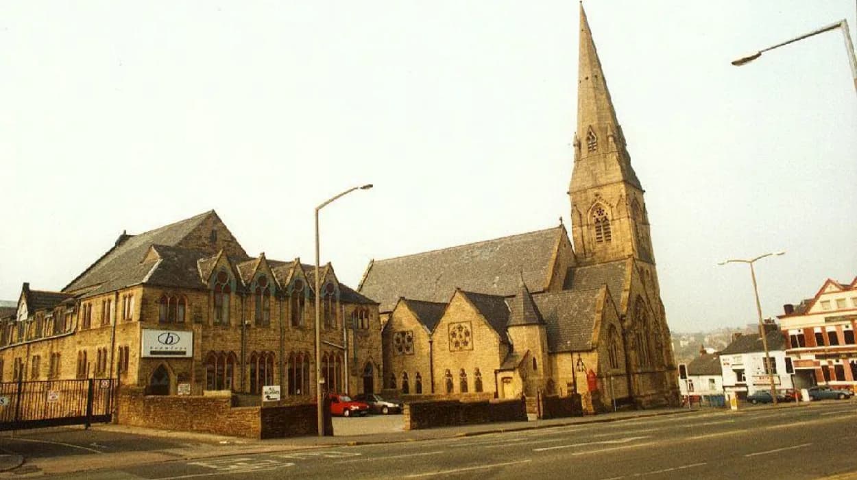
Key landmarks in Astley Bridge include surviving mill structures, St Paul’s Church, historic terraced housing clusters, former bridge crossings, and remnants of industrial infrastructure that collectively represent the district’s textile manufacturing and community development heritage.
St Paul’s Church stands as a central architectural landmark, representing Victorian ecclesiastical expansion tied to population growth during industrialisation. Built in the 19th century, it reflects Gothic Revival design principles common in Lancashire mill towns, characterised by pointed arches, stone construction, and vertical emphasis.
Former cotton mill sites define the industrial core of Astley Bridge. While many have been repurposed or partially demolished, their structural footprints remain visible. These sites demonstrate the scale of textile production that once dominated the valley economy.
Terraced housing rows form another defining landmark category. Built using local stone and brick, these structures housed mill workers and their families. Their uniform design reflects industrial-era efficiency and social stratification in housing provision.
Bridges crossing the River Tonge represent key transport nodes. These crossings enabled movement between mills, housing areas, and surrounding settlements. Their placement illustrates how infrastructure shaped urban growth patterns.
Together, these landmarks create a continuous historical corridor visible during walking exploration.
How did mills and waterways shape Astley Bridge’s urban form?
Mills and waterways determined Astley Bridge’s urban form by anchoring industrial development along the River Tonge, establishing linear settlement patterns, influencing housing density, and creating infrastructure networks aligned with water-powered and steam-powered textile production systems.
The River Tonge functioned as the primary environmental driver of early industrialisation. Water flow provided mechanical energy for early textile machinery before steam engines replaced hydropower. Mills were therefore positioned directly along the riverbanks to maximise energy efficiency.
This spatial logic produced a linear industrial corridor. Factories clustered along the valley floor, while residential housing expanded upward along slopes due to limited flat land availability. This vertical separation remains visible in the district’s topography.
Waterways also shaped sanitation and industrial waste systems. Textile dyeing and processing required substantial water usage, leading to engineered channels and drainage systems. Historical records from Lancashire municipal archives document increasing water management interventions throughout the 19th century.
The industrial layout influenced transport infrastructure. Roads and footpaths followed river alignment, creating long, continuous access routes between production sites and residential zones. This structure remains embedded in modern street planning.
Astley Bridge therefore represents a classic example of water-driven industrial urbanisation in Northern England.
What architectural styles appear along Astley Bridge walking routes?
Architectural styles in Astley Bridge include Victorian Gothic ecclesiastical design, industrial mill architecture in brick and stone, Georgian-influenced terraced housing, and early 20th-century civic reconstruction reflecting functional urban expansion and working-class settlement planning.
Victorian Gothic architecture is most prominently represented in ecclesiastical buildings such as St Paul’s Church. This style emphasises vertical lines, pointed arches, and decorative stonework, reflecting religious and moral symbolism during industrial expansion.
Industrial mill architecture dominates the valley floor. These buildings typically feature large rectangular forms, multi-storey layouts, and repetitive window patterns designed to maximise natural light for textile production. Brick and stone materials provided structural durability for heavy machinery.
Terraced housing exhibits Georgian influence adapted for industrial needs. Rows of identical houses were constructed for efficiency, using locally sourced stone. Narrow streets and uniform façades reflect standardised urban planning practices of the 19th century.
Later civic buildings introduced simplified architectural forms prioritising function over ornamentation. These structures emerged during early 20th-century urban redevelopment phases.
Together, these architectural layers form a visual timeline of Astley Bridge’s development.
How has modern development affected heritage preservation in Astley Bridge?
Modern development in Astley Bridge has partially preserved historical structures through adaptive reuse of mills, integration of heritage housing into residential planning, and conservation of key landmarks, while also replacing some industrial sites with contemporary housing and commercial infrastructure.
Urban redevelopment in Astley Bridge has followed a mixed preservation model. Some former textile mills have been converted into residential apartments and commercial units, preserving external façades while adapting interiors for modern use. This approach maintains architectural continuity while supporting current housing demand.
Historic terraced housing remains largely intact, though modifications include insulation upgrades, roofing replacements, and internal restructuring. These changes preserve external streetscapes while improving living standards.
Certain industrial sites have been demolished and replaced with modern housing estates. These developments alter historical continuity but respond to population growth and urban density requirements.
Conservation policies within Bolton’s planning framework identify key heritage assets for protection. These include ecclesiastical buildings, selected mill structures, and historically significant street layouts.
The result is a hybrid landscape where industrial heritage coexists with contemporary urban form, reflecting broader trends in Northern England’s post-industrial regeneration.
What role does Astley Bridge play in Bolton’s cultural and social history?
Astley Bridge plays a central role in Bolton’s cultural and social history as a former textile production hub, working-class residential district, and migration destination that shaped community identity, labour organisation, and urban demographic expansion during the Industrial Revolution.
Astley Bridge contributed significantly to Bolton’s emergence as a major textile centre. Its mills formed part of a wider industrial network that positioned Bolton among the most productive cotton-spinning towns in Britain during the 19th century.
Socially, the district developed strong working-class communities centred around mill employment. These communities were characterised by shared labour conditions, housing proximity, and local institutions such as churches, schools, and mutual aid societies.
Migration played a key role in shaping demographic structure. Workers arrived from rural Lancashire, Ireland, and other parts of the United Kingdom, contributing to cultural diversity within a concentrated industrial environment.
Educational and religious institutions reinforced community cohesion. Schools and churches served as both social and administrative centres, regulating daily life and supporting literacy and workforce development.
Astley Bridge therefore represents a microcosm of industrial-era social transformation in Northern England.
How can visitors connect historical walking routes with modern attractions in Astley Bridge?
Visitors can connect historical walking routes with modern attractions in Astley Bridge by following river valley paths, exploring preserved mill sites, observing Victorian housing districts, and integrating heritage trails with contemporary parks, retail areas, and community spaces that reflect ongoing urban evolution.
Modern walking experiences in Astley Bridge integrate historical and contemporary environments. River Tonge pathways provide continuous access to both natural landscapes and former industrial zones, allowing visitors to observe the transformation of production sites into green corridors.
Preserved mill structures and repurposed industrial buildings function as anchor points within walking itineraries. These sites connect historical textile production with modern residential and commercial usage.
Residential streets built during the Victorian period remain active neighbourhoods, offering insight into continuity of urban life across centuries. Their preservation supports architectural heritage appreciation within daily living environments.
Public parks and community spaces introduced during later redevelopment phases provide recreational integration points within the historical landscape. These areas demonstrate how post-industrial planning incorporates leisure and environmental restoration.
Astley Bridge therefore functions as a living historical environment where walking routes simultaneously interpret the past and engage with present-day urban identity.
FAQS
What historic landmarks can you see in Astley Bridge?
Key landmarks include St Paul’s Church, former mill sites, Victorian terraced housing, historic bridges over the River Tonge, and remnants of industrial infrastructure.