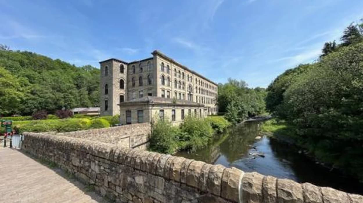
Bolton’s industrial history is closely connected to its rivers, brooks, valleys and water-management infrastructure. The River Croal, River Tonge, Bradshaw Brook and Eagley Brook shaped the location of early mills, transport routes, settlements and later industrial development. Their importance extended beyond supplying water. They influenced land ownership, urban form, employment, engineering and the environmental character of the borough.
Before large steam-powered cotton mills transformed Lancashire, flowing water provided a practical source of mechanical energy. Mill owners selected sites where streams had sufficient gradients to turn waterwheels. Reservoirs, mill ponds, leats and mill races controlled the flow. As industrial technology advanced, steam engines increasingly replaced direct water power, but rivers remained important for manufacturing processes, drainage, transport connections and the organisation of industrial landscapes.
Bolton’s valleys therefore preserve evidence of several stages of industrialisation. Water-powered mills appeared before the dominant steam-powered cotton industry. Later factories occupied the same valleys because established sites already had access to workers, roads, canals, railways and water infrastructure.
Bolton Council’s landscape assessment identifies the borough’s urban valleys as distinctive landscapes containing fast-flowing rivers, wooded cloughs, archaeological sites and post-industrial features. It also records intensive industrial development along the River Tonge, Bradshaw Brook and the Rivers Croal and Irwell between 1700 and 1900.
How did rivers help Bolton develop before the Industrial Revolution?
Before mechanised factories dominated Bolton, rivers provided water for mills, supported agriculture, marked settlement boundaries and helped establish trading communities. Bolton’s position around the River Croal created a foundation for later industrial expansion and concentrated development within accessible valley landscapes.
Bolton developed as a market settlement during the medieval period. Bolton Council identifies the River Croal as an important geographical feature around which the medieval settlement developed. The town occupied a strategic position near the convergence of valleys and routes connecting surrounding communities.
Water was an important economic resource before the Industrial Revolution. Small mills used flowing streams to drive machinery. The technology was comparatively simple but depended on reliable differences in elevation and controlled water flow.
The geography of Bolton was particularly suitable for this form of development. The borough rises towards the West Pennine Moors, while several valleys descend towards the Manchester Basin. Streams and rivers therefore possessed gradients capable of supporting water-powered machinery.
The early industrial landscape was not confined to the eventual town centre. Manufacturing developed along valley floors where water, land and transport access were available. This pattern later became one of the defining characteristics of industrial Lancashire.
The River Croal had particular significance because it ran through the centre of Bolton. It also influenced the physical division of the historic town. Before the creation of Bolton Corporation, the river formed the boundary between Great Bolton and Little Bolton. Bolton Council records that narrow plots between Deansgate and the Croal had both street and river frontage, providing evidence of established settlement and early textile activity.
This relationship between water and settlement explains why industrial archaeology remains concentrated in Bolton’s river valleys. Mills were not randomly distributed across the town. Their locations reflected the availability of natural resources and the practical requirements of manufacturing.
Which rivers and brooks were most important to Bolton’s industrial growth?
The River Croal, River Tonge, Bradshaw Brook and Eagley Brook formed important parts of Bolton’s industrial water network. Their valleys provided sites for mills, manufacturing works, transport infrastructure, reservoirs, housing and later industrial redevelopment across the borough.
The River Croal was central to Bolton’s urban development. It flowed through the town centre before continuing towards its eventual meeting with the River Irwell at Nob End. Its valley became heavily developed during industrialisation.
The River Tonge formed another major industrial corridor. It runs through eastern parts of the borough and connects with Bradshaw Brook. Bolton Council’s landscape research identifies the Tonge Valley as one of the borough’s characteristic urban valleys.
Bradshaw Brook was particularly important in the northern and eastern parts of the borough. It joins the River Tonge, creating a connected valley system that supported industrial development and later public access.
Eagley Brook served the industrial communities around Eagley and areas north of Bolton. The surviving Brook Mill provides direct evidence of the scale and sophistication of the later cotton industry associated with this watercourse.
These waterways were not isolated features. They formed a wider geographical system. Streams descended from higher ground, entered industrial valleys and eventually contributed to larger river systems. Their water supported manufacturing while the valleys provided relatively narrow corridors for roads, railways and canals.
The surviving landscape demonstrates this relationship. Bolton Council records that the River Tonge, River Croal and Bradshaw Brook run through parts of the borough together, with Bradshaw Brook meeting the Tonge and the Croal occupying a separate southern corridor.
The rivers also influenced the later recreational landscape. Bolton Council currently promotes an eight-mile Tonge Trail following the River Tonge and Bradshaw Brook, demonstrating how an industrial water corridor has become part of the borough’s public landscape.
How did water power operate Bolton’s early mills?
Water-powered mills converted the movement of flowing water into mechanical rotation through waterwheels and associated machinery. Mill ponds, races and channels controlled water levels, allowing streams to provide consistent mechanical energy before steam engines became dominant in Bolton’s textile industry.
A waterwheel converted the potential and kinetic energy of water into rotary motion. That motion passed through shafts, gears and belts to operate machinery.
The basic principle was straightforward. Water accumulated or flowed through a controlled channel. The moving water struck or passed beneath a wheel. The wheel rotated. Mechanical power then travelled through the mill.
Mill owners therefore needed more than a natural stream. They required engineering infrastructure. A mill race directed water towards the wheel. A weir controlled the level. A tailrace carried discharged water away from the machinery.
Topography was equally important. A greater vertical difference between the water source and wheel generally provided greater energy. Bolton’s valleys offered this geographical advantage.
The early water-powered textile industry formed part of a wider Lancashire pattern. Historic England’s research into textile Lancashire identifies water-powered mill remains as important evidence for understanding the transformation of the region between approximately 1780 and 1850. Its research includes industrial sites in the Cheesden Valley and Barrow Bridge near Bolton.
Water power also imposed limitations. Seasonal changes in rainfall affected the amount of energy available. Floods could damage infrastructure, while dry periods reduced output. Winter conditions also affected some water-powered systems.
These limitations encouraged technological change. Steam engines provided manufacturers with greater control over production because they did not depend directly on river flow. Bolton’s industrial landscape consequently shifted from small and medium water-powered sites towards increasingly large steam-powered cotton mills.
The transition did not eliminate the importance of water. Industrialists continued to use rivers for drainage, processing, cooling and other industrial requirements. Water infrastructure remained embedded within the physical organisation of factories.
St Helena Mill illustrates this technological transition particularly clearly. Historic England records that the site was first developed as a water-powered mill around 1780. The surviving building dates from around 1820 and was constructed for steam power. By about 1830 it was operating as a cotton waste spinning mill.
Why did cotton mills concentrate around Bolton’s river valleys?
Cotton mills concentrated around Bolton’s river valleys because these locations combined water resources, suitable industrial land, established settlements and transport connections. As steam power expanded, the valleys remained attractive because roads, canals, railways, workers, and established manufacturing infrastructure were already concentrated there.
The growth of cotton manufacturing accelerated Bolton’s transformation during the eighteenth and nineteenth centuries. The availability of water initially influenced mill locations, but industrial concentration later depended on several interconnected factors.
Workers were essential. Mills required large numbers of spinners, weavers, mechanics and other employees. Once industrial communities developed around a mill valley, new businesses benefited from the existing labour supply.
Transport also became increasingly important. The Bolton and Bury Canal opened in stages from 1791, while the Bolton and Leigh Railway opened in 1828. Railways subsequently connected Bolton with wider Lancashire and national markets.
The River Croal corridor demonstrates how industrial development combined different forms of infrastructure. Bolton Council records mills, timber yards, breweries and other industrial premises along the river. The town’s nineteenth-century development also included roads, bridges and increasingly dense housing.
The same concentration created severe urban pressures. Industrial housing occupied narrow plots close to factories and waterways. Bolton Council’s historical assessment identifies high development density and poor living conditions in parts of the Croal valley during the industrial period.
The relationship between industrial buildings and rivers was therefore economic and spatial. Factories required access to resources and transport. Workers required housing close to employment. Roads and bridges connected the valley to the expanding town.
By the nineteenth century, the scale of manufacturing had become substantial. Bolton Council records that the textile industry employed approximately 36,000 people in Bolton by 1911. The figure demonstrates the social scale reached by the industrial system that had developed across the town and surrounding valleys.
The river valleys consequently became industrial corridors rather than isolated mill sites. Mills, workshops, warehouses, worker housing, bridges and transport routes occupied adjoining spaces.
How did the River Croal shape Bolton’s industrial town centre?
The River Croal shaped Bolton’s town centre by influencing early settlement, industrial land use, roads and boundaries. Its valley contained mills and workshops, while later channelisation and culverting concealed much of the river beneath modern infrastructure and altered the historic landscape.
The Croal has a particularly important place in Bolton’s urban history because it passes through the central townscape.
Before municipal consolidation, the river separated Great Bolton from Little Bolton. This boundary reflected the historic administrative structure of the settlement.
Industrial development subsequently occupied the valley. St Helena Mill stood immediately beside the Croal. Historic England describes the surviving building as a cotton waste spinning mill dating from around 1820, with the river running immediately behind it.
Other industrial premises developed nearby. Bolton Council records flax and cotton mills, timber yards and a brewery along the Croal-side industrial landscape around St George’s Road and Bark Street.
The valley also accommodated dense housing. Narrow plots were divided into courts and terraces, producing some of the most crowded residential environments in the town.
Municipal reform followed industrial expansion. Bolton’s existing administrative arrangements struggled with drainage, paving and other problems created by rapid population growth. The Bolton Improvement Act of 1850 transferred important local powers to the borough council.
River engineering became an important part of this urban transformation. The Croal was channelised during the nineteenth century. This changed the physical appearance of the river and helped separate the valley from surrounding streets.
Later twentieth-century redevelopment went further. Bolton Council records that part of the Croal was culverted in the 1980s beneath the Market Hall extension. The river was also culverted in the 1960s in the area associated with the Merchant’s Quarter and the construction of St Peter’s Way.
This process removed much of the visible river from the central urban landscape. Yet surviving buildings and archaeological remains continue to demonstrate the former relationship between water and industry.
St Helena Mill is particularly valuable because its position beside the Croal makes the historical geography visible. The building is listed at Grade II for its special architectural and historic interest.
How did the River Tonge and Bradshaw Brook support industrial communities?
The River Tonge and Bradshaw Brook formed an industrial corridor east and north-east of central Bolton. Their fast-flowing valleys supported mills and bleaching works, while later roads, railways, housing and public paths transformed the same waterways into complex industrial and post-industrial landscapes.
The Tonge Valley was one of Bolton’s important industrial landscapes. Bolton’s Landscape Character Appraisal records intensive development of mills and bleaching works along the River Tonge and Bradshaw Brook between 1700 and 1900.
Bleaching was an important textile process. Cotton cloth required washing and treatment before further manufacture or sale. Water was therefore valuable not only as a source of mechanical power but also as an industrial material.
The geography of the Tonge Valley also helped connect industrial settlements with the wider borough. Valley routes provided relatively direct corridors through otherwise varied terrain.
Bradshaw Brook joined the Tonge, creating another important watercourse within this industrial network. The modern landscape still reflects the former industrial geography.
Bolton Council’s public-rights documentation records a former mill race beside a public footpath near the River Tonge. The existence of a named mill race in the modern rights-of-way record demonstrates how historic water-management infrastructure survives within the contemporary landscape.
The Tonge corridor also retains strong recreational significance. The council’s eight-mile Tonge Trail follows the River Tonge and Bradshaw Brook, linking contemporary walking with a landscape shaped by centuries of industrial activity.
Historical walking routes provide an effective way to understand these connections because industrial archaeology often survives as landscape features rather than complete factories.
To experience this historic landscape in person today, consult our comprehensive [Explore Riverside Walks Across Bolton Offering Beautiful Views Throughout Every Season Year-Round] for itineraries and visiting parameters.
The continuing presence of wooded valleys is equally important. Bolton Council’s environmental assessment identifies the Bradshaw, Eagley and Tonge valleys as landscapes containing fast-flowing brooks, mature woodland and steep cloughs.
These landscapes demonstrate that industrialisation did not erase the underlying geography. Instead, factories, transport routes and settlements were imposed upon existing valleys.
What evidence survives from Bolton’s water-powered industrial past?
Surviving mills, mill races, bridges, viaducts, channels, reservoirs and archaeological sites provide physical evidence of Bolton’s industrial relationship with water. Listed buildings such as St Helena Mill, Croal Mill and Brook Mill preserve different stages of the town’s textile manufacturing history.
Industrial archaeology provides evidence that cannot be understood solely through written records. Buildings reveal manufacturing processes, while mill races and watercourses reveal how industrial sites interacted with their environment.
St Helena Mill represents an early stage in this sequence. Its site originated with a water-powered mill around 1780, while the surviving structure was built around 1820 for steam power.
Croal Mill provides evidence of later industrial development. Historic England records that it was built in 1908 for the Croal Spinning Company Limited. Designed by Bradshaw and Gass, it was a six-storey cotton spinning mill with an engine house, boiler house and rope race. It closed as a cotton mill in 1967 and later became a warehouse.
The Croal Mill complex demonstrates how industrial power technology had changed by the early twentieth century. The building depended on an engine house and boiler infrastructure rather than the simple waterwheel arrangements of earlier mills.
Brook Mill in Eagley provides another significant example. Historic England records that the building was originally constructed as a twist mill in 1871 and rebuilt in 1887. It was used for finishing and winding before later production activities.
The wider transport infrastructure also survives. The Croal Viaduct was constructed in 1847 for the Bolton and Blackburn Railway under engineer Charles Vignoles. Its ironwork was supplied by Ogle and Son of Preston.
Bradshaw Brook Viaduct provides another example. The Grade II-listed railway structure dates from 1847–48 and carries the former Blackburn, Darwen and Bolton Railway across Bradshaw Brook. It stands approximately 120 feet high and contains nine semicircular arches.
These structures demonstrate the evolution of industrial infrastructure. Watercourses first influenced mill locations. Railways later crossed the same valleys to move raw materials, finished goods and people.
The archaeological record therefore extends beyond individual mills. It includes channels, foundations, bridges, viaducts, reservoirs, workers’ housing and surviving street patterns.
How did Bolton’s rivers change after the decline of the cotton industry?
After cotton manufacturing declined, Bolton’s rivers lost much of their direct industrial function but retained environmental, archaeological and recreational importance. Former mill sites became warehouses, industrial premises, housing areas and heritage sites, while some waterways remained channelled or culverted.
Bolton’s textile industry declined during the twentieth century as international competition, changing technology and wider economic restructuring reduced Lancashire’s manufacturing dominance.
The decline transformed the relationship between rivers and industry. Mills that once required power, water and large workforces closed or changed use.
Historic England records that Croal Mill ceased cotton production in 1967 and later operated as a warehouse. St Helena Mill remained disused from 1979.
Bolton Council has also recorded that the borough’s last working mill eventually closed during the late 1970s. The decline ended an industrial system that had employed tens of thousands of local people.
The rivers nevertheless remained visible in parts of the borough. In other locations, engineering works altered their appearance.
The Croal is the clearest example. Channelisation during the nineteenth century changed its valley. Twentieth-century culverting subsequently placed sections underground. Bolton Council records the partial culverting beneath the Market Hall extension during the 1980s.
Industrial decline also created new opportunities for environmental restoration and public access. Former industrial valleys now contain woodland, footpaths, open spaces and wildlife habitats.
The council’s environmental assessment identifies the borough’s valleys as landscapes supporting wildlife and public access. It specifically identifies the Bradshaw, Eagley and Tonge valleys as containing mature woodland and fast-flowing watercourses.
The modern landscape therefore contains several historical layers. A visitor can encounter a nineteenth-century mill, a railway bridge, a modified river channel and a modern public footpath within the same geographical corridor.
This layered character is central to understanding Bolton’s industrial heritage.
Why are Bolton’s rivers important for heritage preservation today?
Bolton’s rivers are important heritage assets because they preserve the geographical framework of industrialisation. Protecting surviving mills, waterways, archaeological remains, bridges and valley landscapes preserves evidence of how water, technology, transport, labour and urban growth transformed Bolton.
Industrial heritage preservation requires more than protecting individual buildings. The relationship between a mill and its river is part of the historical significance.
A mill separated from its watercourse can lose important geographical context. Likewise, a surviving railway viaduct becomes more historically meaningful when its relationship with the industrial valley is understood.
Bolton’s listed industrial buildings provide formal protection for important structures. Historic England’s National Heritage List for England includes St Helena Mill, Croal Mill and Brook Mill among the borough’s designated heritage buildings.
Archaeological evidence also remains important. Bolton Council identifies parts of the Croal valley as potentially archaeologically valuable, despite extensive clearance and redevelopment.
The preservation challenge is particularly significant where rivers have been culverted. Underground watercourses can be difficult to interpret from the modern streetscape. Historic maps, archaeological surveys and surviving industrial buildings become essential evidence.
Old maps provide another valuable resource for genealogical and local-history research. River corridors often correspond with historic streets, mills, courts and worker housing. Researchers tracing families associated with Bolton’s textile industry can use these geographical relationships to understand where people lived and worked.
The river valleys also have educational value. They allow students to connect industrial technology with geography, architecture, economics and social history. A single mill site can demonstrate changes in energy production, manufacturing organisation, transport and urban development.
Bolton’s rivers therefore form a continuous historical record. Their significance begins with the physical geography of flowing water and extends through medieval settlement, early milling, the cotton revolution, steam technology, railway expansion, urban engineering and post-industrial regeneration.
The story also demonstrates why Bolton became one of Lancashire’s major textile centres. The rivers did not independently create industrialisation. They provided geographical conditions that industrial entrepreneurs, engineers, workers, transport companies and municipal authorities exploited and transformed.
What is the lasting legacy of Bolton’s industrial rivers?
The lasting legacy of Bolton’s industrial rivers is a landscape where natural waterways and industrial infrastructure remain interconnected. The Croal, Tonge, Bradshaw Brook and Eagley Brook continue to reveal how water shaped manufacturing, settlement, transport, architecture and modern heritage.
Bolton’s industrial growth was fundamentally a geographical process. Mills followed valleys. Workers followed employment. Roads and railways followed practical routes. Housing filled available land. Factories expanded around established infrastructure.
The River Croal became central to the town’s urban development. The River Tonge and Bradshaw Brook formed an important industrial corridor. Eagley Brook supported major manufacturing sites. Each watercourse contributed to a wider industrial landscape rather than operating as an isolated resource.
The technology changed over time. Early mills relied directly on flowing water. Steam engines later supplied mechanical power. Railways and canals expanded access to national and international markets. Large cotton mills transformed the scale of production.
The physical evidence remains substantial. Listed mills, former mill races, railway viaducts, channels and valley landscapes provide tangible connections to Bolton’s industrial past.
Some rivers are now hidden beneath roads and buildings. Others remain open within parks, woodland and walking routes. The contrast between visible and buried waterways is itself part of Bolton’s urban history.
The modern Tonge Trail demonstrates the changing role of these landscapes. A watercourse once associated with manufacturing now forms part of a public recreational route.
Historic England’s research into Lancashire’s industrial landscape similarly emphasises the importance of understanding buildings, infrastructure and landscape together. Its work on textile Lancashire identifies the dramatic transformation of both rural and urban environments during the Industrial Revolution.
For Bolton, the rivers provide the geographical thread connecting these transformations.
Their importance therefore extends beyond the history of cotton. They explain why industries appeared where they did, why particular neighbourhoods developed in particular valleys, why railways crossed certain routes and why remnants of industrial activity remain concentrated around waterways.
Today, Bolton’s rivers are simultaneously environmental features, archaeological resources, public landscapes and historical evidence. Protecting their surviving industrial connections ensures that future generations can understand how water helped shape the town that exists today.
The industrial landscape created around these waterways remains one of Bolton’s most significant historical records. Its mills and bridges document technological change. Its valley settlements document population growth. Its altered channels document municipal engineering. Its surviving paths and waterways provide access to the same geography that supported centuries of economic development.
Bolton’s industrial rivers are therefore not simply remnants of a vanished manufacturing economy. They are the enduring physical framework through which the borough’s industrial history can still be studied, interpreted and preserved.
FAQS
Which rivers powered Bolton’s industrial growth?
The main waterways were the River Croal, River Tonge, Bradshaw Brook and Eagley Brook. Their valleys provided water for early mills and later became important locations for cotton factories, transport infrastructure, housing and industrial communities.