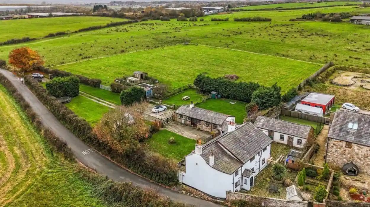
Harwood, now within the Metropolitan Borough of Bolton, has a rural history that predates its modern suburban character by centuries. Its farms, fields, commons, barns, lanes and family holdings reveal how agriculture shaped settlement, land ownership, work and community life before industrialisation transformed the wider Bolton area.
The historical record shows that farming was not a marginal activity in Harwood. It formed part of the township's economic foundation from at least the early seventeenth century and remained embedded in the landscape as industrial employment expanded around Lancashire.
Harwood's rural heritage is particularly valuable because surviving property records preserve details that are often absent from broader accounts of Bolton's industrial history. Deeds, wills, leases, field names, enclosure records and surviving farmhouses provide evidence of how individual families used and managed the land.
What was Harwood like before industrialisation?
Before industrialisation, Harwood was a predominantly rural township containing farms, common land, fields, meadows, pasture, cottages and small settlements. Agriculture supported families through livestock, crops, dairying, domestic production and related trades before industrial employment became increasingly important.
Harwood formed part of the ancient parish of Bolton-le-Moors in Lancashire. Its historical identity was based on the township rather than the modern administrative boundaries associated with Bolton.
The surviving documentary evidence demonstrates a landscape divided between privately held farms and common land. Farms contained houses, barns, gardens, folds, meadows, pasture and cultivated fields. A fold was an enclosed farmyard or settlement area associated with agricultural buildings and dwellings.
The northern and north-western parts of Harwood were particularly associated with upland farms. The Knotts, for example, occupied land between roughly 700 and 850 feet above sea level. Historical research identifies the area as a long-established farming zone extending towards Affetside.
The landscape was not uniformly cultivated. Farmers used different parts of their holdings according to soil, elevation and agricultural purpose. Field names recorded in seventeenth-century documents distinguish rye fields, meadows, pasture, crofts, banks and other areas.
This terminology provides evidence of a mixed farming economy. A meadow supplied grass for hay, pasture supported grazing animals, while arable fields were cultivated for crops.
Harwood's rural landscape therefore operated as a connected agricultural system rather than a collection of isolated farms.
When did farming become established in Harwood?
Farming in Harwood has documented roots at least as far back as the early seventeenth century, while the township's medieval land organisation was already established. Records from 1600 to 1670 identify named farms, yeoman families, agricultural fields, common rights, livestock and cultivated acreage.
The documentary record becomes particularly detailed during the seventeenth century.
Research into the Knotts farms identifies three principal holdings in the early 1600s: Top o' th' Knotts West, Top o' th' Knotts East and Hoyles Fold. Together, these holdings represented approximately 66 Cheshire acres, equivalent to about 142 statute acres.
The use of Cheshire acres is important because historical land measurements differed from the modern acre. Researchers therefore need to distinguish the unit used in original documents from modern statutory measurements.
A lease dated 1607 records land associated with Elizabeth Haslam, widow of William Haslam. Her family connection provides evidence that farming holdings were transmitted through families and marriage networks.
In 1612, the Moseley Manor of Harwood was sold for £1,100 to five Harwood yeomen: Matthew Harrison, Henry Haworth, Raufe Higson, Lawrence Horrocks and Edward Greenhalgh. The transaction demonstrates the economic importance of local yeoman landownership.
A yeoman was a landholding farmer below the traditional landed gentry in social status. In Harwood, yeomen could own or acquire substantial agricultural holdings and participate directly in local property transactions.
The records also show that farming and other occupations were not mutually exclusive. Henry Haworth was described as a yeoman in property documents but as a mason in his will. His career illustrates how rural households combined agriculture with skilled trades.
How did seventeenth-century Harwood farms operate?
Seventeenth-century Harwood farms combined arable cultivation, meadow, pasture, livestock keeping, buildings and common rights. Farm inventories show animals, tools, barns, byres and household goods operating together as one agricultural economy supporting both production and family life.
The 1622 inventory of Henry Haworth provides unusually detailed evidence.
His livestock included two oxen, two mares, two horses, nine cattle, three calves and nine sheep. His agricultural equipment included a plough, pitchforks and other farming tools. The inventory also valued dung and manure at 20 shillings.
These details reveal the practical structure of farming.
Oxen were important sources of draught power before the widespread mechanisation of agriculture. Horses also supported transport and farm work. Cattle provided milk, meat and breeding stock, while sheep supplied wool and other products.
Manure was itself an economic resource. Livestock waste returned nutrients to cultivated land, helping maintain soil fertility in a farming system that lacked modern synthetic fertilisers.
The farm therefore depended upon a continuous relationship between animals, crops, grassland and buildings.
The documented field names reinforce this structure. Top o' th' Knotts West included Coal Pit Field, Barn Field, Lime Field, Lower Meadow and Coal Pit Croft. Top o' th' Knotts East included Middlemost Meadow, Great High Field, Rye Highfield and several pasture areas.
These names preserve evidence of land use. Rye Highfield indicates cereal cultivation, while meadow names indicate grass production. Calf-related field names point towards livestock management.
The presence of coal pits also demonstrates that agricultural landscapes could contain other extractive activities. The earliest documented coal mining evidence in Harwood identified by the Knotts research dates from 1620.
Who owned and worked the farms of Harwood?
Harwood's farms were occupied by yeomen, tenant farmers and family groups whose property arrangements involved inheritance, marriage settlements, leases and sales. Families including the Haworths, Haslams, Harrisons, Bridges and Levers appear in surviving seventeenth-century records.
Land ownership in historic Harwood was complex.
The 1612 purchase of the Moseley Manor demonstrates that local farming families could participate in substantial property transactions. The five Harwood yeomen involved in that purchase were not simply agricultural labourers. They possessed sufficient financial resources and social standing to acquire land collectively.
Marriage also played a major role in property transmission.
A 1620 marriage settlement involving Robert Haslam and Marie Astley recorded financial arrangements connected with their marriage. The settlement provided mechanisms for property to pass to heirs and specified conditions affecting occupancy and inheritance.
Such documents are valuable to genealogists because they connect people to particular farms, fields and family relationships.
The property records also demonstrate that farms could be divided or consolidated. Individual holdings changed hands through sales and leases, while related properties were sometimes brought under common ownership.
Thomas Lever provides an example of consolidation. During the seventeenth century he acquired several holdings in the Knotts area, eventually bringing together properties that formed the basis of Hoyle's Fold Farm.
Farm workers themselves appear less frequently in surviving legal records than landowners and tenants. Wills nevertheless provide glimpses of servants and household labour. Haworth's 1622 will included bequests to servants, demonstrating that agricultural households employed people beyond the immediate family.
What were Harwood's common lands?
Harwood's common lands were areas where inhabitants possessed recognised rights of use alongside privately occupied farms. Common rights formed part of the agricultural economy by providing access to shared resources before formal enclosure reorganised land ownership and use.
Common land was fundamental to rural communities across historic England.
In Harwood, rights of common were attached to specific properties. Seventeenth-century deeds repeatedly mention these rights when farms were transferred. Their inclusion indicates that access to common resources formed part of the economic value of a holding.
Common rights could support grazing and other rural activities. Their precise form depended upon local custom and the terms attached to individual holdings.
The existence of common land also meant that Harwood's landscape could not be understood solely through private farms. Individual properties operated within a wider communal system.
This system changed significantly at the end of the eighteenth century.
The Act for the Enclosure of Harwood Commons was approved in 1797. The enclosure process was subsequently recorded through an award and associated documentation covering the period from 1797 to 1801.
Enclosure was a legal and administrative process that reorganised common and open land into defined parcels. In practical terms, it changed how land was accessed, managed and recorded.
The Harwood enclosure records are particularly valuable because they include pre-enclosure farms, maps, roads, allotments and farms established after enclosure.
The surviving evidence therefore allows researchers to compare Harwood before and after a major agricultural land-use transformation.
How did the enclosure of Harwood Commons change rural life?
The enclosure of Harwood Commons between 1797 and 1801 reorganised shared land into defined holdings and altered the agricultural landscape. It also influenced roads, farm construction, property boundaries and the relationship between individual farms and common resources.
Enclosure represented a major structural change in Harwood's rural economy.
Before enclosure, common rights connected individual holdings to shared land. After enclosure, land was allocated into defined parcels. This created clearer boundaries and gave owners or occupiers more direct control over particular areas.
The historical study of the enclosure identifies maps from 1797, 1798 and 1801 and documents associated with the enclosure award. It also identifies a new road system established during the process.
This road development mattered because agriculture depended upon movement.
Farmers needed routes for transporting crops, livestock, manure, tools and building materials. Improved roads also connected rural settlements to markets and neighbouring townships.
The enclosure records identify farms built after enclosure, including Raikes and Pawsey Bank.
This provides direct evidence that enclosure affected the physical appearance of Harwood rather than simply changing legal ownership.
The enclosure period also coincided with wider changes in the region. In 1797, the Little Bolton to Edenfield Turnpike Trust was also established. Historical research into Bradshaw Chapel records identifies both developments as significant changes affecting the locality's economy, population and settlement.
Agricultural change therefore occurred alongside improved transport and increasing regional economic integration.
What did historic Harwood farmhouses look like?
Historic Harwood farmhouses were practical agricultural buildings combining domestic accommodation with spaces for livestock, storage and farm work. Surviving examples preserve local construction traditions through stone walls, stone-slate roofs, mullioned windows, barns, byres and associated farm buildings.
Brook Fold Farmhouse on Brookfold Lane provides a surviving example of Harwood's architectural farming heritage.
Historic England records the building as a Grade II listed farmhouse dating from the mid-eighteenth century. It is constructed from dressed stone and has a stone-slate roof. The two-storey building contains mullioned windows and an attached wing.
The rear includes a lean-to cow house.
This feature is particularly important for understanding rural life. The farmhouse was not simply a residence. Its architecture reflected the close relationship between household and agricultural production.
The building's two-bay arrangement, stone construction and agricultural attachment represent a regional building tradition shaped by local materials and farming requirements.
Listing under the Planning (Listed Buildings and Conservation Areas) Act 1990 recognises the building's special architectural or historic interest.
Other surviving structures and archaeological records contribute to the same picture.
An archaeological building survey was undertaken at Asmus Fold, Brook Fold Lane, Harwood, by the University of Manchester Archaeological Unit in 2006. The project formed part of wider archaeological building research in Greater Manchester.
Such surveys are important because farm buildings can preserve evidence that written records do not. Changes in walls, roof structures, openings and internal arrangements can reveal how buildings were adapted for different agricultural purposes.
How did farming connect with Harwood's industrial development?
Harwood's agricultural economy did not disappear when industrialisation expanded. Farming, domestic production, quarrying, coal extraction and textile employment existed alongside one another, creating a mixed rural-industrial landscape connected to the wider Bolton economy.
The wider Bolton district became internationally associated with cotton manufacturing, but Harwood retained important rural characteristics.
The historical evidence from the Knotts demonstrates that agricultural properties could also contain coal pits. In 1620, Robert Haslam had rights connected with an existing coal pit and provisions allowing further coal pits to be sunk under specified conditions.
This demonstrates that rural land supported multiple economic functions.
Later industrialisation increased the importance of transport and nearby employment. Harwood's position within the Bolton region connected agricultural households with expanding markets and industrial workplaces.
The 1870–72 Imperial Gazetteer described Harwood as a township of approximately 1,100 acres. It recorded 2,055 people and 435 houses and noted a cotton mill, mines and quarries.
The same source recorded real property valued at £5,556, including £800 associated with mines and £400 with quarries.
These figures demonstrate that nineteenth-century Harwood was no longer an exclusively agricultural economy.
Yet industrial activity did not erase the older landscape immediately. Farms, fields, lanes and rural buildings remained part of the township while mills and extractive industries expanded.
This mixed character is central to understanding Harwood's history.
How did rural families adapt during the nineteenth century?
During the nineteenth century, Harwood households adapted to an economy increasingly shaped by industrial employment while retaining agricultural properties, livestock, gardens and rural occupations. The township developed as a mixed landscape where farming and industry operated within the same community.
The nineteenth century brought major demographic and economic changes across Lancashire.
Harwood experienced population growth alongside the development of manufacturing and extractive industries. The 1870–72 population figure of 2,055 demonstrates the scale of the community by the later Victorian period.
Industrial employment offered alternatives to agricultural work. Mills, mines and quarries generated jobs, while improved transport increased connections with Bolton and surrounding communities.
Farmers nevertheless continued to maintain holdings.
The survival of agricultural buildings is important evidence of this continuity. Farmhouses were often adapted rather than abandoned. Agricultural buildings could be repaired, extended or converted as farming requirements changed.
Rural households also remained connected to domestic production. Lancashire's historic economy frequently combined agricultural work with textile-related activity, although the specific balance varied between households.
This flexibility helped rural communities respond to economic change.
The transformation was therefore gradual. Harwood did not move directly from farming to industry. Instead, agricultural and industrial systems overlapped for generations.
Which historic farm buildings survive in Harwood today?
Surviving farmhouses and archaeological building records provide physical evidence of Harwood's rural past. Brook Fold Farmhouse is a protected Grade II example, while documented farm sites such as Asmus Fold preserve evidence for studying historic agricultural buildings and their adaptation.
Brook Fold Farmhouse is one of the clearest officially recognised examples.
Historic England identifies it as a mid-eighteenth-century Grade II listed building at 63 Brookfold Lane. Its stone construction, mullioned windows, roof form and attached cow house preserve features associated with historic agricultural occupation.
Its survival matters because historic farmhouses are three-dimensional sources.
Written records describe ownership and transactions. Buildings show how people physically organised domestic and agricultural life.
The relationship between living accommodation and livestock space is especially significant. A cow house attached to the rear demonstrates how animal husbandry formed part of the building's original function.
Asmus Fold provides another research opportunity. Its 2006 archaeological building survey demonstrates the continuing scholarly interest in Harwood's historic rural structures.
Local historical research also identifies other former agricultural sites and farms connected with Harwood's development. The documented studies of Harwood Hill Farms and Riding Gate cover the seventeenth, eighteenth, nineteenth and twentieth centuries, demonstrating the long chronological continuity of the area's rural history.
For visitors interested in experiencing the landscape that developed around these historic farms, consult our comprehensive [Best Dog-Friendly Walks in Harwood for Visitors Exploring Bolton With Their Pets] for itineraries and visiting parameters.
How can Harwood's field names help historians understand rural life?
Historic field names preserve evidence of farming practices, landscape features, ownership and local geography. Names such as Rye Highfield, Great Calf Hey, Lower Meadow and Coal Pit Field identify agricultural functions and physical characteristics that have disappeared or changed.
Field names are valuable historical evidence because they often survive after the original land use has changed.
The Knotts records contain extensive examples.
Top o' th' Knotts West included Barn Field, Lime Field, Coal Pit Field, Lower Meadow and Coal Pit Croft. Top o' th' Knotts East included Rye Highfield, Great Calf Hey, Park and Fell Meadow. Hoyles Fold included Rye Field, Great Croft, Field at the Door and Field above the Well.
The vocabulary reveals the agricultural landscape.
"Rye" indicates cereal cultivation. "Meadow" identifies grassland used for hay. "Calf" suggests land associated with young cattle. "Barn" points towards farm infrastructure. "Coal Pit" records mineral extraction.
Field names also help genealogists.
A historical deed can identify a person, property and field simultaneously. When combined with parish registers, wills and other records, these references allow researchers to reconstruct family movements and property inheritance.
Harwood's field-name evidence therefore connects agricultural history with family history.
What role does Harwood's rural heritage play today?
Harwood's rural heritage provides surviving evidence of centuries of agriculture, landownership and community life. Historic farmhouses, field patterns, archaeological surveys, documentary records and local research collectively preserve a landscape that predates modern Bolton's urban development.
Modern Harwood forms part of the Metropolitan Borough of Bolton, but its administrative position does not erase its earlier township history.
Bolton Council's historical records show that Harwood was included within the Bolton Rural Sanitary Authority established in 1872. In 1895, the authority became a Rural District Council, and in 1898 Harwood was transferred to the Turton Urban District.
These administrative changes illustrate how rural communities were gradually incorporated into modern systems of local government.
The final major administrative transformation came in 1974, when the present Metropolitan Borough of Bolton was created.
Harwood's rural identity nevertheless survives through buildings, landscape features and historical documentation.
Historic England's designation of Brook Fold Farmhouse demonstrates the formal importance attached to individual heritage assets. Local historical publications provide another layer of preservation by recording farms, families, field names and property transactions that are not always visible in the modern landscape.
The preservation of this evidence has implications for education.
Students can use farm records to study landownership, social history, agricultural technology and industrialisation. Genealogists can trace families through leases, wills, marriage settlements and property sales. Heritage researchers can compare historic maps with present-day landscapes.
Harwood's farming heritage therefore remains an active historical resource rather than a closed chapter.
Why is farming heritage important to Harwood's history?
Farming heritage is essential to understanding Harwood because agriculture shaped its settlement, property ownership, family structures, roads, buildings and landscape before and during industrialisation. Surviving records demonstrate that modern Harwood developed from a long-established rural community.
The history of Harwood cannot be reduced to the industrial history of Bolton.
Its farms existed for centuries before nineteenth-century population growth transformed the surrounding region. Seventeenth-century inventories reveal livestock, tools and agricultural land. Property deeds document families and ownership. Enclosure records show the reorganisation of common land. Historic farmhouses preserve the physical architecture of rural life.
The chronology is clear.
By the early 1600s, Harwood contained established farms with named fields and identifiable families. In 1612, local yeomen participated in the purchase of the Moseley Manor of Harwood. By 1622, detailed inventories recorded livestock and farming equipment. During the seventeenth century, landholdings changed through sales, leases and inheritance.
The enclosure process of 1797–1801 reorganised common land and affected farms, roads and boundaries.
By the Victorian period, Harwood had become a larger and more economically diverse township. The 1870–72 record describes a population of 2,055 and identifies cotton manufacturing, mining and quarrying alongside the established rural landscape.
The surviving Brook Fold Farmhouse and archaeological research at Asmus Fold provide physical evidence of that rural inheritance.
Harwood's farming heritage therefore explains how a rural township developed within the expanding industrial region around Bolton. Its fields, farms and families formed the foundation upon which later transport, industry, housing and administration developed.
For modern researchers, this heritage offers a direct route into local history. For educators, it provides evidence for teaching rural society and industrialisation. For visitors, it gives greater meaning to the surviving lanes, buildings and open landscape.
Harwood's agricultural past remains visible in its historic fabric and documentary record. Preserving that evidence protects an essential part of the area's identity and ensures that the rural foundations of modern Harwood remain part of Bolton's historical story.
FAQS
What is Harwood's farming heritage?
Harwood's farming heritage dates back at least to the early 1600s in surviving documentary records. Farms such as those at the Knotts supported livestock, crops, meadows and pasture and were managed by local yeoman families.