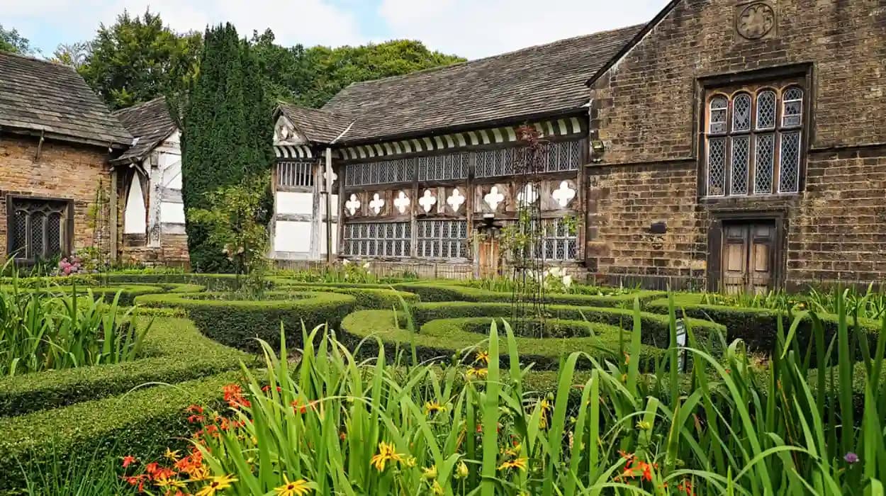
Smithills is one of Bolton’s most historically layered landscapes, combining ancient woodland, medieval landholding, farming, coal mining, quarrying, moorland, and industrial-era infrastructure. Its surviving woods and wooded cloughs preserve evidence of centuries of environmental and human change beside Smithills Hall and Winter Hill.
What is the ancient woodland history of Smithills?
Smithills contains ancient woodland alongside moorland, farmland, grassland and wooded cloughs, forming a historic landscape shaped by medieval estates, agriculture, coal mining, quarrying, Victorian landscaping and modern conservation across northern Bolton.
The term ancient woodland refers to woodland that has existed continuously since at least 1600 in England, although individual trees within it are not necessarily ancient. The ecological importance of ancient woodland comes from the continuity of soils, fungi, plants, deadwood, insects and other organisms associated with long-established woodland habitats.
Smithills is important because its woodland cannot be understood separately from its wider landscape. The present Smithills Estate covers about 684.66 hectares, or 1,691.79 acres, and includes woodland, wooded cloughs, grassland, farmland, moorland and bog habitats. The Woodland Trust identifies ancient woodland as one of the habitats present across the estate.
The landscape occupies the northern edge of Bolton and rises towards Winter Hill and the West Pennine Moors. Its valleys and cloughs provided sheltered environments for trees, streams and cultivation, while higher ground developed into open moorland.
This combination explains why Smithills contains such different landscape types within a relatively compact area. Woodland occupies sheltered slopes and valleys, while exposed upland ground supports heath and moorland vegetation.
The archaeological record extends well beyond the medieval period. Woodland Trust research identifies Mesolithic flint scatters dating from the eighth to mid-fourth millennia BC as the earliest evidence of human activity within the wider Smithills Estate. Other reported finds include a Bronze Age stone hammer and palstave, a whetstone, a blue ribbed bead, a bottle neck described as Romano-British and a bronze coin of uncertain date.
These discoveries do not establish that continuous woodland existed throughout those periods. They instead demonstrate that people repeatedly used the landscape long before the documented medieval estate emerged.
When did people first use the Smithills landscape?
Human activity at Smithills extends back to prehistoric times, with Mesolithic flint scatters providing the earliest identified evidence, followed by reported Bronze Age and Romano-British artefacts before medieval landholding created a documented estate.
The Mesolithic period followed the last Ice Age and preceded widespread farming. Communities relied heavily on hunting, fishing and gathering, moving through landscapes rather than establishing the permanent agricultural settlements that developed later.
Flint scatters at Smithills provide archaeological evidence of this early activity. Their presence places the estate within the broader prehistoric landscape of the West Pennine uplands.
The reported Bronze Age finds indicate later activity. A stone hammer and palstave were reportedly discovered in 1812. A palstave is a type of Bronze Age axe designed for use with a haft. Such objects demonstrate metalworking-era activity in the wider landscape, although isolated finds do not define the exact location or purpose of settlement.
The Roman period also forms part of Smithills’ archaeological background. Reported finds include objects described as Romano-British, but the surviving evidence does not demonstrate the existence of a major Roman settlement at Smithills.
The landscape therefore developed through repeated phases of human use rather than through one single historical transformation. Woodland, open ground and agricultural areas changed in response to climate, grazing, cultivation, fuel requirements and settlement.
This distinction is essential when discussing ancient woodland. A woodland identified as ancient today represents ecological continuity, but the wider landscape has experienced thousands of years of human intervention.
How did medieval landownership shape Smithills woodland?
Medieval ownership established Smithills as a managed estate, with the Hospitallers holding the land from the late twelfth century or earlier and successive families occupying it before later ownership transformed its agricultural and woodland management.
The medieval history of Smithills is closely connected with the Knights Hospitaller, a religious military order that held the estate from the late twelfth century or earlier. Historic England records the Hospitallers as owners before the Dissolution of the Monasteries.
The Dissolution of the Monasteries was the process by which Henry VIII’s government suppressed religious houses in England between 1536 and 1541 and transferred their property to the Crown and private owners. Smithills subsequently passed through different ownership arrangements.
The Radcliffe family became resident at Smithills from 1335. The estate later passed by marriage to the Barton family during the fifteenth century. This succession demonstrates the importance of landed estates as both economic assets and family property.
Smithills Hall became the architectural centre of this estate system. Historic England identifies its earliest surviving building phase as a late fourteenth-century open hall, while another listing describes the origins of the hall house as early fourteenth century.
The distinction between the dates reflects the complex development of the building. Smithills Hall was not constructed as one complete structure. It evolved through additions and alterations over several centuries.
Medieval estate management involved fields, woodland, pasture, watercourses and buildings operating as an integrated economic unit. Woodland supplied timber, fuel and other resources, while valleys and lower ground supported cultivation and grazing.
The wooded cloughs around Smithills therefore formed part of a working landscape rather than a recreational woodland designed for visitors.
What does Smithills Hall reveal about the historic woodland landscape?
Smithills Hall demonstrates how medieval settlement, later estate management and nineteenth-century landscape design became integrated with woodland, streams, parkland and moorland surrounding one of Bolton’s most important surviving historic buildings.
Smithills Hall is a Grade I listed building and one of the most important surviving medieval buildings in the region. Historic England records the hall’s late fourteenth-century open-hall core and later extensions, including nineteenth-century work by architect George Devey.
The relationship between building and landscape is especially significant. Historic England’s registered landscape record describes approximately 48 hectares of historic grounds surrounding the hall, including parkland, gardens, wooded pleasure grounds and valleys.
Raveden Clough forms a wooded eastern boundary. Dean Brook and Raveden Brook run through the landscape, creating sheltered corridors where woodland developed.
The nineteenth century introduced a more deliberate ornamental treatment. Formal terraces, lawns, avenues, wooded pleasure grounds, bridges and water features were incorporated into the estate.
This landscape design did not erase the earlier natural geography. Instead, Victorian estate planners incorporated existing valleys and woodland into a designed landscape.
Historic England records a wooded valley north of the hall, mature trees, a rustic bridge and cascade, and paths following watercourses. It also records woodland plantations and belts of trees shown on nineteenth-century Ordnance Survey mapping.
The surviving landscape therefore contains different layers of woodland history. Some areas reflect long-established woodland habitats, while others represent deliberate nineteenth-century planting and estate landscaping.
How did farming change the Smithills landscape?
Agriculture became a major force in shaping Smithills, with six farms recorded in 1620 and fourteen by 1769, demonstrating the expansion and subdivision of farmland across a landscape that also retained woodland, moorland and estate-managed ground.
The 1620 estate map prepared by William Senior provides one of the most important documentary records of Smithills. It identifies six farms associated with the estate. By 1769, the number had increased to fourteen.
The 1769 farms ranged from approximately 2.6 hectares to 48.9 hectares. This variation demonstrates the fragmented agricultural structure of the estate.
Agricultural expansion altered the balance between fields, woodland and open ground. Woodland edges were influenced by grazing, timber extraction, boundary construction and cultivation.
Dry-stone walls became an important physical feature of the upland landscape. They divided fields and helped define agricultural boundaries while also connecting farms with tracks and moorland routes.
The surviving walls are historical evidence because they reveal how land was divided and managed. Their relationship with woodland and cloughs also demonstrates the practical geography of estate farming.
Agriculture later declined. The Woodland Trust identifies increasing management costs, neglect during the Second World War and wider changes in farming as factors in the decline of agriculture at Smithills.
This decline created a different conservation challenge. Historic farmland became part of a landscape increasingly valued for woodland, biodiversity, recreation and heritage.
How did coal mining and quarrying affect Smithills woodland?
Coal mining and quarrying transformed parts of Smithills through pits, shafts, spoil heaps, tramways, workers’ housing and excavated ground, leaving archaeological features that remain important evidence of Bolton’s industrial landscape.
Smithills was never isolated from Bolton’s industrial development. Coal mining operated within the estate, particularly on and around the moorland.
The Woodland Trust records archaeological evidence associated with coal mining, including workers’ cottages constructed because the mining areas were remote.
A University of Manchester research source describing the 1996 archaeological survey identifies coal-mining features including Bell Pit, two pits at Halliwell, a pit at Hollin Hey and another at Smithills Dean. It also records shafts, tramways, spoil heaps and the route known as Coal Pit Road.
Quarrying also altered the landscape. Brown Stones Quarry appeared on the 1849 Ordnance Survey map and was enlarged by the later nineteenth century. Other quarry locations and associated workings were recorded in archaeological research.
The industrial landscape therefore existed alongside woodland rather than replacing it completely. Woodland provided timber and fuel resources, while industrial activity occupied specific parts of the estate.
Industrial archaeology is particularly valuable at Smithills because many physical features remain embedded within the landscape. Spoil heaps, old routes, walls, shafts and excavated areas reveal how workers and materials moved through the estate.
The historical woodland must therefore be studied together with industrial archaeology. Trees and archaeological features occupy the same physical landscape and record different aspects of its past.
How did nineteenth-century industry change the woodland around Smithills Hall?
Nineteenth-century industrial development introduced tramways, coal transport, quarrying and expanded settlement while the Ainsworth estate simultaneously developed formal gardens, pleasure grounds and landscaped woodland around Smithills Hall.
The Ainsworth family acquired Smithills in 1801 and retained ownership until 1938, when Bolton Corporation acquired the estate.
The nineteenth century was therefore a major period of simultaneous industrial and landscape change.
Historic England records an early nineteenth-century tram road associated with the estate. It probably transported coal from mining areas. The route crossed wooded cloughs using substantial causeways.
This infrastructure demonstrates how industrial transport penetrated the rural landscape.
At the same time, the hall grounds received formal improvements. George Devey carried out major extensions and alterations to Smithills Hall during the 1870s and 1880s, creating the distinctive Victorian architectural layer visible today.
The gardens included terraces, lawns, ornamental trees and wooded pleasure grounds. A kitchen garden north of the hall included glasshouses, with documentary evidence from 1853 referring to the cultivation of pineapples.
This combination of industrial infrastructure and elite landscape design illustrates the complexity of nineteenth-century Smithills. The estate was simultaneously a productive economic landscape, an industrial resource and a designed country-house environment.
Why is the 1896 Smithills moorland access campaign historically important?
The 1896 Smithills moorland campaign connected woodland, industrial communities and public access, when around 10,000 people gathered to challenge restrictions on access to the moors, decades before the famous 1932 Kinder Scout mass trespass.
Public access became a major social issue in late nineteenth-century Bolton. Smithills and Winter Hill stood beside an expanding industrial town whose residents sought access to upland countryside.
The Woodland Trust records that 10,000 people took to the Smithills moors in 1896 to demand access rights. The demonstration occurred more than thirty years before the Kinder Scout mass trespass of 1932.
The dispute involved Colonel Richard Henry Ainsworth, then associated with the Smithills estate. Barriers were erected on routes used by local people.
The event was significant because access to upland landscapes was connected with the daily geography of industrial Bolton. Workers, families and residents used paths across the moors for travel and recreation.
The campaign became part of the longer British history of public access to countryside. It established Smithills and Winter Hill as an important location in the development of the right-to-roam movement.
The modern legal framework is different. The Countryside and Rights of Way Act 2000 created statutory access rights over mapped areas of open country, mountain, moor, heath and down in England and Wales.
The 1896 campaign therefore provides historical context for modern access to Smithills. Present-day walking routes exist within a landscape where public access has itself been a subject of historical conflict.
What happened to Smithills after the estate became public property?
Bolton Corporation acquired the Smithills estate in 1938, creating the foundation for later public heritage management, while Smithills Hall subsequently became a museum and the wider landscape developed into a major public countryside resource.
The transfer to Bolton Corporation in 1938 marked a major change in ownership. The estate moved from long-term private ownership into municipal control.
Smithills Hall later became a museum. Historic England records the medieval section as having opened to the public in 1963, while the Victorian rooms opened during the early 1990s.
The change in use transformed the meaning of the historic building. Smithills Hall became an educational and heritage resource rather than simply a private residence.
Bolton Council later undertook restoration work on the hall. In 2017, a £500,000 project began to restore the West Wing, including the Devey Room, Ainsworth Room, entrance hall and associated facilities.
The project also demonstrated the close relationship between estate conservation and historic-building conservation. Funding for the work was enabled partly through the sale of land forming the nearby Smithills Estate to the Woodland Trust.
The modern history of Smithills is therefore not simply a story of woodland preservation. It is a combined history of heritage buildings, archaeological remains, public access, farmland, biodiversity and landscape management.
When did the Woodland Trust begin restoring Smithills Estate?
The Woodland Trust acquired two-thirds of the present Smithills Estate in 2015 and the remaining third in 2017, establishing a large-scale conservation programme for ancient woodland, new woodland, moorland, grassland, farmland and historic landscape features.
The Woodland Trust acquired two-thirds of the estate in 2015 and the remaining portion in 2017. The organisation describes Smithills as the largest site it has acquired in England.
The present estate covers approximately 684.66 hectares. Its habitats include ancient woodland, broadleaved woodland, grassland, moorland, heathland and bog. Parts of the moorland fall within the West Pennine Moors Site of Special Scientific Interest, or SSSI.
An SSSI is a legally designated site recognised for special wildlife, geological or physiographical interest. The designation places additional importance on protecting the ecological characteristics of the landscape.
The restoration programme aims to strengthen connections between existing woodland areas. Woodland Trust plans include substantial tree planting, natural regeneration, wildlife corridors, ancient woodland restoration and improved public access.
The organisation has also described tree-planting programmes involving 130,000 trees, with the objective of doubling tree cover and creating ecological corridors. Other Woodland Trust material describes larger planting totals as the restoration programme has developed.
These new trees are not classified as ancient woodland. Newly planted woodland and ancient woodland have different ecological and historical statuses. The restoration objective is to strengthen the existing ancient woodland network while creating additional habitat.
What archaeological evidence survives in Smithills woodland?
Smithills contains archaeological evidence from prehistoric activity through medieval settlement and industrialisation, including flint scatters, mining remains, quarry features, tramways, workers’ housing, historic boundaries and structures associated with Smithills Hall.
Archaeological research provides an essential method for understanding woodland history because many changes leave physical traces rather than written records.
The University of Manchester Archaeological Unit conducted an archaeological survey of the Smithills Estate in 1996, followed by a Stage 2 archaeological evaluation of Smithills Hall in 1998. Historic England lists these studies among the principal references for the site.
The archaeological record includes prehistoric artefacts, industrial workings and historic infrastructure. Mining remains include shafts, pits, spoil heaps and transport routes. Quarrying created additional excavated features.
The landscape around Smithills Hall also contains historic garden and parkland features. Historic England identifies terraces, a ha-ha, ornamental lawns, wooded valleys, bridges, ponds, paths and a kitchen garden.
A ha-ha is a sunken boundary designed to separate formal garden space from grazing land without interrupting the visual appearance of the landscape with a conventional fence.
Historic maps are especially important. William Senior’s 1620 map, Hugh Oldham’s 1769 estate plan, the first Ordnance Survey mapping of the 1840s and 1850s, and later 1893 and 1907 Ordnance Survey maps allow researchers to compare changes in fields, woodland, buildings, paths, water features and industrial infrastructure.
This documentary sequence provides a long-term record of landscape change and helps distinguish older woodland from later planting.
How is Smithills ancient woodland being protected today?
Modern conservation at Smithills combines ancient woodland restoration, new tree planting, habitat connectivity, moorland management, archaeological protection, public access planning and community involvement across a large historic landscape.
The Woodland Trust’s current management approach treats Smithills as a connected landscape rather than a collection of isolated trees.
Ancient woodland restoration is one component of the programme. Another involves new woodland creation that links existing woodland fragments. This approach improves ecological connectivity while retaining the distinction between ancient and newly established woodland.
The estate also requires moorland management. The 2018 Winter Hill fire demonstrated the vulnerability of upland habitats to wildfire. Woodland Trust records a fire close to the television mast on 28 June 2018, followed by another fire at the eastern end of the estate the next day.
More recent management includes wildfire prevention, restoration planning and public education. Bolton Council consultation material records the Woodland Trust’s concerns about repeated wildfire incidents and the need for preventative measures on the estate.
Conservation also includes protection of public access. This has particular historical significance because Smithills was already a major location in the nineteenth-century struggle for access to open countryside.
The landscape consequently combines ecological conservation with cultural heritage. Protecting woodland also protects archaeological features, historic routes, field boundaries and the setting of Smithills Hall.
Which historic features connect Smithills woodland with Bolton’s industrial past?
Smithills woodland retains physical connections with Bolton’s industrial history through coal pits, quarries, tramways, workers’ housing, Coal Pit Road, dry-stone boundaries and the wider network linking upland resources with nineteenth-century communities.
The industrial history of Smithills was closely connected with Bolton’s rapid expansion during the Industrial Revolution.
Coal was essential to nineteenth-century industrial production and domestic heating. Smithills contained coal workings, and the remote location required supporting infrastructure and worker accommodation.
Coal Pit Road remains an especially important historical name. It reflects the relationship between transport and extraction on the moor.
Quarries also supplied stone for construction and infrastructure. Their excavations altered slopes and created features that remain visible in the modern landscape.
The development of Barrow Bridge provides another connection between Smithills and industrial society. The nearby settlement developed as a workers’ community associated with Dean Mills. Research cited by the University of Manchester records the community reaching approximately 800 residents at its height.
The result was a landscape in which woodland, industrial buildings, farms, worker housing and transport routes existed within the same geographical system.
For modern heritage interpretation, this industrial connection is essential. Smithills is not only an ancient woodland landscape. It is also evidence of the economic systems that helped transform Bolton from a rural settlement into an industrial town.
How can visitors understand Smithills woodland history today?
Visitors can understand Smithills as a connected heritage landscape by examining woodland, cloughs, historic routes, Smithills Hall, archaeological remains, field boundaries, moorland and industrial features rather than treating the area as woodland alone.
Smithills provides unusually strong opportunities for outdoor historical interpretation because physical evidence survives across the landscape.
Smithills Hall provides the clearest architectural starting point. The Grade I listed medieval building demonstrates the importance of the estate from the medieval period through the Victorian era.
The surrounding woodland reveals a different part of the story. Raveden Clough, Dean Brook, wooded slopes and historic parkland demonstrate how natural landform and estate management interacted.
The wider estate adds prehistoric and industrial evidence. Flint scatters, mining features, quarry sites, tramways, dry-stone walls and moorland routes extend the historical narrative beyond the hall itself.
To experience this historic landscape in person today, consult our comprehensive [Discover Peaceful Reservoir Walks in Belmont Perfect for Weekend Nature Adventures Together] for itineraries and visiting parameters.
Public access also has a direct historical dimension. The routes across Smithills connect with the 1896 access campaign and the longer development of public rights to the countryside.
Visitors should also understand that conservation areas are working landscapes. Ancient woodland requires protection from damaging activity, while moorland is vulnerable to wildfire and other pressures.
The historical value of Smithills therefore depends on both access and responsible management. The landscape remains useful for education, heritage research, ecological study and local recreation.
Why does the ancient woodland history of Smithills matter to Bolton?
Smithills matters because its ancient woodland and wider landscape preserve evidence of prehistoric activity, medieval landownership, agricultural change, industrialisation, public access campaigns and modern conservation within one historically continuous part of Bolton.
Smithills provides a rare example of landscape continuity in which environmental and social history can be studied together.
The prehistoric evidence establishes human activity thousands of years before the medieval estate. Medieval ownership created a documented landed landscape. Agricultural expansion changed field patterns. Coal mining and quarrying introduced industrial infrastructure. Victorian owners redesigned the grounds around Smithills Hall. Public access campaigns transformed the relationship between local communities and upland land. Modern conservation now seeks to protect and reconnect the remaining habitats.
The importance of the woodland therefore extends beyond the trees themselves.
Ancient woodland preserves ecological continuity. Archaeological features preserve evidence of human activity. Historic maps preserve changing land boundaries. Smithills Hall preserves architectural evidence. Public routes preserve aspects of social history.
The landscape also demonstrates how environmental history and industrial history overlap. The same valleys that supported woodland also provided routes for streams, transport infrastructure and industrial activity.
Modern conservation adds another historical layer. The Woodland Trust’s acquisition from 2015 onwards created a new phase in which large-scale landscape restoration became central to Smithills’ future.
The programme includes ancient woodland restoration, new woodland creation, habitat corridors, moorland restoration and public access improvements. These measures are intended to protect the landscape while increasing ecological resilience.
For Bolton, Smithills represents a long record of interaction between people and landscape. Its woodland is part of that record, not separate from it.
The future historical significance of Smithills will depend on preserving archaeological evidence, maintaining ancient woodland, managing new planting appropriately, protecting moorland, conserving Smithills Hall and keeping the landscape accessible.
The result is a heritage landscape where environmental conservation and local history remain inseparable. Smithills preserves the physical evidence needed to understand how northern Bolton developed from prehistoric activity and medieval estate management into an industrial community and, ultimately, a modern landscape focused on heritage, biodiversity and public access.
FAQS
What is Smithills known for?
Smithills is known for its ancient woodland, Smithills Hall, medieval estate history, coal-mining remains, historic farmland, moorland and its connection with the nineteenth-century campaign for public access to the countryside.