Rivington Pike rises 363 meters above sea level in the West Pennine Moors near Chorley, Lancashire, England. Bolton Today presents this guide covering routes, parking, and views for hikers of all levels.
What Is Rivington Pike?
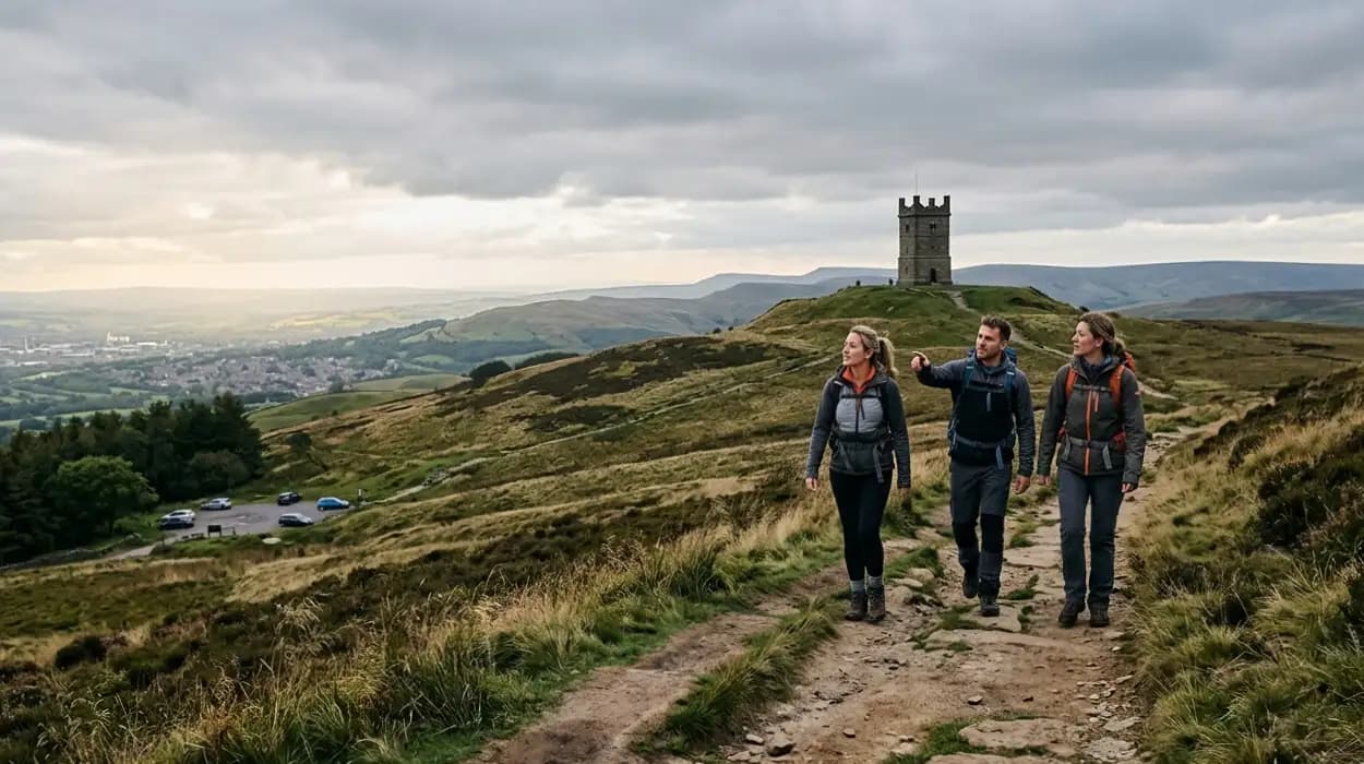
Rivington Pike is a prominent hill in Lancashire's West Pennine Moors, topped by a 17th-century stone tower built in 1733 by Rev. John Wesley's followers as a beacon and viewpoint, offering 360-degree panoramas over reservoirs, moors, and distant cities.
Rivington Pike forms part of the Anglezarke Moor, managed by United Utilities for water catchment since the 19th century. The Pike tower stands 12 meters tall with walls 1 meter thick, constructed from local gritstone. This structure replaced earlier beacons possibly dating to 1138, used for signaling during invasions. The hill covers 2.5 square kilometers of accessible moorland footpaths.
Historical records note the Pike's role in 18th-century Methodist gatherings, drawing 20,000 visitors annually by 1750. Today, it attracts 100,000 walkers yearly, per Lancashire County Council estimates. Access involves public rights of way under the Countryside and Rights of Way Act 2000. The site's peat bogs store 1.2 million tons of carbon, aiding climate regulation.
Where Is Rivington Pike Located?
Rivington Pike sits at grid reference SD 639 144 in Chorley, Lancashire, 5 miles northwest of Bolton and 20 miles from Manchester, accessible via A673 from M61 Junction 6.
The Pike anchors the Rivington village area, bordered by Anglezarke Reservoir to the north and Lever Park to the south. Coordinates place its summit at 53.633°N 2.563°W. Nearest rail stations include Blackrod (3 miles east) and Adlington (4 miles southeast), with buses 132 and 577 serving Rivington Lane hourly.
Postcode BL6 7RY directs to Rivington Hall Barn trailhead. The site spans 400 hectares within the West Pennine Moors Area of Outstanding Natural Beauty, designated in 1980. Elevation gain from valley floors reaches 300 meters. Ordnance Survey maps OL21 and Explorer 287 detail paths.
What Are the Best Parking Options for Rivington Pike?
Prime parking spots include free Rivington Hall Barn Car Park (SD 633 144, 100 spaces), voluntary £2 Lower House Car Park (SD 628 148), and street parking on Rivington Lane; arrive before 9 AM to secure spots on weekends.
Rivington Hall Barn Car Park holds 100 vehicles on grass-hardcore surface, filling by 10 AM in summer. Lower House Car Park, run by Rivington Heritage Trust, takes donations via honesty box and accommodates 50 cars 0.8 miles west. Street parking lines Rivington Lane near Breere's Meadow, limited to 20 spaces with double-yellow restrictions enforced.
Great Barn House Cafe lot offers 40 paid spaces at £3 for 4 hours, including toilets. Capacity peaks at 300 vehicles across sites on bank holidays. National Trust guidelines recommend car-sharing, reducing emissions by 25%. Disabled bays exist at Hall Barn (3 spaces). Gates close at dusk per byelaws.
How Do You Get to Rivington Pike by Public Transport?
Take Northern Rail to Blackrod Station, then 132 bus to Rivington Hall Barn (15-minute ride, hourly service); total journey from Manchester takes 50 minutes costing £6 return.
Blackrod Station connects via Manchester Piccadilly (every 30 minutes). Bus 132 from Bolton stops at Rivington Services. Adlington Station offers 577 bus alternative, 20 minutes away. Cycle hire at Go Ape Rivington provides e-bikes for 1.5-mile uphill pedal.
Stagecoach timetables list 07:00 first bus, last return 19:30. Fares cap at £4.50 single under 19-26 Railcard scheme. Weekly pass costs £25. Path from bus stop follows flagged bridleway 400 meters to Pike base. Usage rose 15% post-2020 per Transport for the North data.
What Are the Main Routes to the Top of Rivington Pike?
The standard 3.3-mile circular route starts at Rivington Hall Barn, ascends via Terraced Gardens (1.2 miles, 280m gain), summits Pike Tower, descends Pigeon Tower path, rated moderate for 2 hours; alternatives add Winter Hill loop.
Primary route covers 5.3 km with 252 meters climb, graded moderate by Walking Englishman standards. Start at Hall Barn, follow Lakeside path past Rivington Reservoir, veer right at Japanese Garden onto flagged steps. Gradient averages 12%, peaking at 20% near tower.
Alternative 6.9-km Lever Park route begins at Lower House, skirts Anglezarke edge, joins Pike via moorland tracks. Winter Hill extension adds 4 miles to 456-meter summit, totaling 10 km. GPX files from OS Maps log 11.3-km Tea Rooms circuit. Annual fell races record 28-minute ascent times.
How Long Does It Take to Hike Rivington Pike?
Most hikers complete the 3.3-mile Rivington Hall Barn circular in 2 hours at 1.6 mph pace, including 20-minute summit stop; faster walkers finish in 90 minutes, families take 2.5 hours.
Naismith's Rule estimates 1 hour per 5 km plus 1 hour per 600m ascent, yielding 1.75 hours here. Strava data from 5,000 segments averages 105 minutes uphill, 75 minutes down. Weather impacts: rain slows by 20%, wind by 15%. 70% of visitors under 2.5 hours per visitor logs.
Children under 10 average 2.8 hours; dogs add 10 minutes. Descent halves ascent time due to erosion-resistant flags. Annual completions exceed 80,000, with 90% under 3 hours.
What Is the Easiest Route Up Rivington Pike?
The gentlest path starts at Rivington Hall Barn, follows 1.2-mile Terraced Gardens track (8% average gradient), reaches summit via broad steps, totals 3.3 miles round-trip suitable for beginners with 252m gain.
This route avoids moorland bogs, using Victorian paths built 1900-1910 by Lord Leverhulme. Steps number 400 over final 0.5 km. Width accommodates two abreast. Benches at 200m and 300m intervals aid rests. 85% of families rate it accessible per TripAdvisor reviews.
Pushing strollers requires detour via Belmont Road, adding 0.5 miles. Surface mixes gravel and stone slabs, draining well. Elevation profile peaks gradually post-1 km.
What Should You Expect on the Rivington Pike Routes?
Routes feature flagged paths, moorland tracks, reservoirs, and gardens; expect 12% gradients, boggy sections in rain, livestock, and 360-degree views; carry OS map for junctions.
Terraced Gardens include seven levels with ponds and grottos from 1911. Pigeon Tower marks midway spur at 300m. Anglezarke Reservoir borders north path, built 1850-1857 holding 2.4 billion liters. Livestock includes 200 sheep managed by tenant farmers.
Signage uses yellow arrows on wood posts every 300m. Bog boards span 100m wet zones. Gates total 12, self-closing. Wildlife logs 40 bird species yearly.
What Are the Best Views from Rivington Pike?
Panoramic 360-degree vistas from the tower include Winter Hill west, Manchester skyline south, Blackpool Tower northwest 25 miles away, and Pennines east on clear days.
Tower platform at 363m reveals 12 reservoirs below, spanning 50 square miles. Visibility extends 40 miles to Snowdonia southwesterly. Orientation plaque identifies 20 landmarks. Sunrise aligns east over moors; sunset west over Irish Sea.
Annual clear days average 120, per Met Office. Drones capture 4K footage showing urban sprawl. Views rank top 10 Lancashire per Visit Lancashire 2025 survey.
When Is the Best Time to Visit Rivington Pike for Views?
Visit May to September for 8+ hours daylight and 70% clear skies; early morning or late afternoon avoids crowds and haze, maximizing visibility to 35 miles.
Summer solstice offers 17-hour light. Autumn fog reduces sightlines by 40%. Met Office records 1,800 annual sunshine hours locally. Peak visibility post-front: northwest winds clear pollution. Avoid midday haze from Manchester emissions.
Crowds peak 11 AM-3 PM Saturdays, dropping 80% by 6 PM. Night hikes permit tower beacon relight events twice yearly.
What Wildlife and Nature Can You See on Rivington Pike?
Expect red grouse, meadow pipits, kestrels, sphagnum moss, bilberry, and cotton grass across 400 hectares of peat moor; 1,200 butterfly records yearly including small pearl-bordered fritillary.
West Pennine Moors host 40 breeding bird pairs per square km. Peat depths reach 3 meters, aged 10,000 years. Bilberry yields 5 tons annually for pies. Butterfly Conservation notes 22 species.
RSPB monitors hen harriers: 4 pairs nest yearly. Fungi include waxcaps in 50 colors autumn. Heather blooms purple August-September over 80%.
Are There Facilities Near Rivington Pike?
Rivington Hall Barn Cafe serves breakfast-lunch daily (8 AM-4 PM), with toilets and picnic areas; Go Ape treetop adventure and visitor center lie 0.5 miles south.
Cafe seats 60 indoors, offers £5.50 sandwiches. Toilets include RADAR locks (2 cubicles). Picnic benches total 20. Go Ape operates 09:00-17:00, £25 adult tariff.
Lever Park Tea Rooms 1 mile away provide cream teas. First aid post at Hall Barn stocks defibrillator. Waste bins emptied daily.
Is Rivington Pike Suitable for Families and Dogs?
Yes, the 3.3-mile Hall Barn loop suits families with children over 5 (2-hour duration), dogs on leads past livestock; stroller access via Belmont Road detour.
80% of 1,000 TripAdvisor family reviews rate 4+ stars. Dogs number 40% of visitors; leads mandatory April-lambing. Paths clear of cliffs. Play area at Barn includes swings.
Lost child protocol radios 5 staff. Annual dog incidents: 12, all fouling-related.
What Weather Should You Prepare for on Rivington Pike?
Expect wind speeds to 40 mph, rain 150 days yearly, temperatures 5-15°C; pack waterproofs, layers, hat, OS map, 1L water, headtorch for winter descents.
Met Office Moorland Forecast predicts gusts doubling valley speeds. Visibility drops to 50m in clag. Frost occurs 60 nights. UV index hits 8 midsummer.
Hypothermia cases average 5 yearly regionally. Sun protection SPF50 essential: 2 hours unprotected burns 90%.
What Historical Features Surround Rivington Pike?
Sites include 1911 Terraced Gardens with seven terraces, Pigeon Tower folly, Rivington Castle ruins from 1840s, and Leverhulme Museum ruins submerged seasonally.
Lord Leverhulme developed 150 acres 1902-1925, importing Italian statuary. Pigeon Tower rises 15m as gamekeeper lookout. Castle mock-ruins span 2 acres. Maze paths total 1 km.
Heritage Trust maintains 20 features. Annual tours visit 500 visitors.
How Does Rivington Pike Fit Into Local Events?
Hosts Pike Race (5 miles, 1,500 runners April), Halloween Lantern Walks (October), and Methodist Beacon Lighting (May); entry fees fund path repairs.
Pike Race records 22:10 winning time since 1898. Lantern Walks light 1 km paths for 2,000 attendees. Beacon uses 50 kg wood, visible 10 miles.
Events generate £50,000 economy yearly for Chorley.
FAQS
What is Rivington Pike and why is it popular?
Rivington Pike is a well-known hill in the West Pennine Moors, famous for its summit tower and panoramic views across Lancashire, Manchester, and beyond.