Extreme weather refers to meteorological phenomena that fall into the top or bottom ten percent of the historical observational record for a specific region. These events deviate significantly from localized baseline averages and display unprecedented intensity, duration, or spatial extent.
To understand these deviations, meteorologists analyze long-term baseline periods, typically spanning 30-year blocks as standardized by the World Meteorological Organization. For instance, the current baseline period uses observations from 1991 to 2020. When an atmospheric event exceeds the 90th or 95th percentile of all recorded data within that window, it is classified as extreme. These events occur across various atmospheric parameters, such as temperature, precipitation, barometric pressure, and wind speed.
The science of statistical attribution evaluates how much human-induced climate change alters the probability of these events. Researchers use peer-reviewed computer simulations to compare our actual atmosphere with a hypothetical, pre-industrial atmosphere free of human greenhouse gas emissions. For example, a major Met Office attribution study verified that the record-breaking warmth of 2025—where the United Kingdom reached an absolute annual mean temperature of 10.09°C—would occur only once every 780 years without human activity. In our current climate, it is expected roughly every three years.
Why Is Severe Weather Becoming More Frequent And Intense Globally?
Severe weather is escalating because rising global greenhouse gas concentrations trap excess thermal energy within the Earth system. This warming alters fundamental thermodynamic properties of the atmosphere and shifts large-scale jet stream patterns, which locks dangerous weather systems over specific regions.
The primary driver behind this escalation is thermodynamics. According to the Clausius-Clapeyron relation, a well-established law of physics, the water-holding capacity of the atmosphere increases by approximately seven percent for every 1°C of warming. This increased capacity accelerates evaporation rates from oceans and soil, storing vast amounts of latent heat energy in the troposphere. When this moisture condenses, it releases that latent energy, fueling more intense convective storms and leading to extreme rainfall events.
On a macro level, this trapped energy causes the Arctic to warm more than twice as fast as the equator, a process known as Arctic amplification. This rapid warming reduces the temperature gradient between the polar and tropical regions. Because that temperature difference drives the jet stream—the high-altitude band of wind that moves weather systems from west to east—the jet stream slows down and develops wide, looping waves. These slow loops create "atmospheric blocking patterns," trapping weather systems in place for extended periods. This blocking effect causes intense heatwaves, like the European heat dome of May 2026, or prolonged rainfall that leads to severe flooding.
What Are The Main Classifications Of Extreme Weather Events?
Extreme weather events are categorized into four major atmospheric classifications: thermal extremes, hydrological extremes, convective storms, and winter meteorological anomalies. Each category is defined by distinct physical mechanisms, pressure setups, and specific regional impacts.
Thermal Extremes
Thermal extremes include prolonged heatwaves, heat domes, and severe droughts. These occur when high-pressure systems stall over a region, forcing air downward in a process called subsidence. This downward compression warms the air mass, clears cloud cover, and allows intense solar radiation to bake the ground. A prime example occurred on May 26, 2026, when Kew Gardens in London recorded an all-time May maximum daily temperature of 35.1°C. Droughts develop when these high-pressure zones persist for months, drying out vegetation and soil, and creating prime conditions for wildfires.
Hydrological Extremes
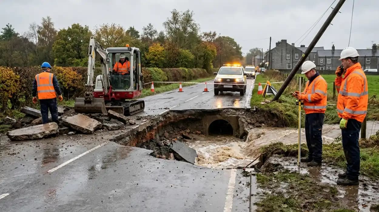
Hydrological extremes involve intense, localized flash floods and prolonged regional flooding. These events are triggered by slow-moving frontal systems or atmospheric rivers—narrow corridors of concentrated moisture in the atmosphere that carry vast amounts of water vapor. When these systems stall over land or hit topography like hills and mountains, they drop heavy rain that quickly overwhelms soil absorption limits and drainage networks.
Convective Storms
Convective storms include severe thunderstorms, tornadoes, derechoes, and tropical cyclones (such as hurricanes and typhoons). These storms are powered by strong atmospheric instability, high humidity, and rapid vertical wind shear (changes in wind speed and direction with altitude). Warm, moist air rises rapidly into cooler air, creating massive updrafts that generate destructive winds, large hail, and torrential rainfall.
Winter Meteorological Anomalies
Winter meteorological anomalies consist of blizzards, ice storms, and sudden stratospheric warming events. Sudden stratospheric warming disrupts the polar vortex, a band of fast-moving winds high above the Arctic. When the polar vortex weakens or splits, it allows freezing arctic air to spill southward into mid-latitude regions like northern Europe and North America, causing rapid drops in temperature and heavy snowfall.
How Do Extreme Rain Systems Form and Cause Severe Flooding?
Extreme rain systems form when unstable, moisture-rich air masses rise rapidly, cool, and condense over a concentrated geographic area. Flooding occurs when the volume of precipitation exceeds the natural infiltration capacity of the soil and the structural limits of drainage infrastructure.
The process begins with strong solar heating or atmospheric fronts forcing warm, moist air upward. As this air rises into the lower-pressure zones of the upper troposphere, it expands and cools adiabatically. Once the temperature drops to the dew point, water vapor condenses onto microscopic aerosols, creating dense storm clouds. If the atmosphere has high precipitable water values, these cloud droplets grow rapidly through coalescence, where colliding droplets merge into heavy rain.
When this rain hits the ground, it follows two paths: it either infiltrates the soil or becomes surface runoff. Soil has a maximum infiltration rate dictated by its composition and pre-existing moisture levels. Clay soils, like those found across Greater Manchester, have low infiltration rates because of their tightly packed particles. If previous rainfall has already saturated the ground, the infiltration capacity drops to zero, forcing all new rain to become surface runoff. This water pours directly into streams, rivers, and urban drainage networks. If the runoff volume exceeds the maximum carrying capacity of these channels, the water breaks over the banks, causing widespread inundation.
What Historical Weather Anomalies Have Impacted Local Regions?
Historical weather anomalies across the United Kingdom show a clear long-term shift toward higher temperatures and more intense rainfall. Long-running data records, like the Central England Temperature series, demonstrate that the top five warmest years on record have all occurred since 2000.
The Long-Term National Record
Observational data from the Met Office confirms that the UK climate is getting warmer, wetter, and sunnier. The year 2025 officially ranks as the warmest year on record since national gridded data collection began. This trend continued into 2026, with seven of the ten warmest springs in history occurring since 2001, specifically 2025, 2026, 2024, 2017, 2023, 2007, and 2011. While 2025 was relatively dry with 90% of the long-term average rainfall, it sat between the exceptionally wet years of 2023 and 2024, highlighting the sharp swings between hydrological extremes.
The Regional Focus on Greater Manchester and Bolton
Local climate trends for Greater Manchester and the specific coverage area of Bolton Today highlight a distinct vulnerability to both extreme heat and intense rainfall. Nestled near the West Pennine Moors, Bolton has a maritime climate that is heavily influenced by surrounding hills, which trap incoming Atlantic moisture. During the heatwave in late May 2026, local weather stations in Bolton recorded a peak afternoon temperature of 31.1°C (88°F) on May 25, accompanied by a sharp drop in relative humidity to 31%.
This extreme heat was followed by intense convective setups, bringing localized thundery downpours over the region. These sudden shifts echo historic local events, such as the severe flooding of the River Croal and River Irwell, where rapid runoff from the Pennine hills regularly tests local flood defenses and urban drainage systems.
How Does Extreme Climate Shift Impact Critical Urban Infrastructure?
Extreme climate shifts disrupt critical urban infrastructure by overwhelming design thresholds that were built for historical weather baselines. Excessive heat deforms physical materials, while severe flooding short-circuits electrical substations and structurally weakens transportation networks.
The built environment in towns like Bolton was engineered using historical weather data that no longer matches current realities. During severe heatwaves, high ambient temperatures cause thermal expansion in steel rail tracks, which can distort the lines and trigger train cancellations. Roads also suffer, as prolonged solar radiation melts asphalt binders, leading to rutting and structural cracking under heavy vehicle loads. Furthermore, electrical grids experience high stress during heatwaves because of increased demand for cooling, which causes transformers to overheat and reduces the efficiency of transmission lines.
Hydrological extremes pose an even greater threat to older industrial towns. When intense downpours hit urban areas, rainwater floods the drainage networks. Many older towns rely on combined sewerage systems that carry both wastewater and stormwater in a single pipe. When these systems are overwhelmed, they discharge untreated sewage directly into local rivers through storm overflows to prevent effluent from backing up into homes.
Additionally, fast-moving floodwaters cause scour—the erosion of soil and sediment around bridge foundations—which threatens the structural integrity of historic stone and brick bridges.
What Long-Term Economic And Ecological Consequences Face Communities?
The long-term consequences of extreme weather include soaring financial losses from property destruction, rising insurance premiums, structural damage to ecosystems, and a sharp decline in agricultural productivity due to shifting seasonal cycles.
Financial and Insurance Implications
The financial toll of extreme weather strains both public budgets and private households. As flooding and severe storms become more frequent, insurance companies face escalating claims, forcing them to raise premiums across high-risk postcodes. In some vulnerable areas, property insurance may become entirely unavailable, causing property values to drop and leaving homeowners without a safety net. Local councils must also redirect funds from public services toward repairing damaged roadways, reinforcing retaining walls, and maintaining flood defenses.
Ecological and Agricultural Disruption
Ecosystems face severe disruptions as climate baselines shift. Prolonged heatwaves and sudden droughts dry out peat bogs and woodlands, killing off native plant species and destroying vital habitats for local wildlife. The UK Climate Change Committee warns that if global warming reaches 2°C by 2050, shortfalls in the daily water supply could exceed five billion liters, creating intense competition for water between natural habitats, human consumption, and agriculture.
The agricultural sector faces immediate threats from these shifts. Unseasonably wet springs, like those seen in 2024, waterlog fields and prevent farmers from planting crops on time. Conversely, sudden summer heatwaves stunt crop growth and dry out grazing pastures, forcing livestock farmers to purchase expensive imported feed. These compounding factors lower domestic food yields and drive up food prices for consumers.
How Can Municipalities Adapt To Mitigate Extreme Meteorological Risks?
Municipalities can mitigate extreme meteorological risks by upgrading to sustainable drainage infrastructure, installing modern flood barriers, revising building codes to prevent overheating, and restoring upstream natural environments to slow down floodwaters.
Engineering Urban Resilience
To handle intense rainfall, local authorities are moving away from traditional concrete drainage channels and adopting Sustainable Drainage Systems. These systems use permeable paving blocks, rain gardens, and bioswales—vegetated ditches designed to slow down and filter stormwater runoff. These features mimic natural ground conditions, absorbing rainwater where it falls and easing the pressure on underground sewer networks.
For existing buildings, updates to planning regulations are needed to tackle indoor overheating. Municipalities can mandate the installation of reflective roofing materials, external window shutters, and mechanical ventilation systems in new developments to keep indoor spaces safe during intense summer heatwaves.
Upstream Catchment Management
Managing flood risk effectively requires looking beyond urban centers to entire river catchments. Natural Flood Management involves working with upstream landowners to slow the flow of water before it ever reaches towns.
- Peatland Restoration: Restoring degraded peat bogs on high ground allows the land to act like a giant sponge, holding back vast volumes of rainwater.
- Woodland Creation: Planting native trees along hillsides increases intercept rates, as leaves and roots catch and slow down rainfall.
- Leaky Dams: Installing woody debris dams inside small upstream streams intentionally slows down the flow, storing water temporarily in fields and reducing the peak volume that rushes down river channels during a storm.
What Practical Actions Can Individuals Take to Prepare For Severe Weather?
Individuals can prepare for severe weather by signposting local emergency alerts, installing property-level flood protection, clearing household drainage points, insulating lofts to counter heatwaves, and checking on vulnerable neighbors during extreme temperature events.
Resilience begins at the household level. Property owners in areas prone to surface water flooding can install property-level protection assets, such as removable flood barriers for doors, non-return valves on sewer pipes to prevent backflow, and water-resistant wall rendering. Keeping gutters, downpipes, and nearby street gullies clear of leaves and debris ensures that heavy rainfall can drain away efficiently without pooling around home foundations.
To prepare for heatwaves, adding high-grade loft insulation helps block external heat from radiating down into living spaces. During hot spells, keeping windows and curtains closed on the sunny side of the house during the day prevents solar heat gain.
Residents can stay informed by signing up for direct weather warnings from the Environment Agency and the Met Office. Local digital publications like Bolton Today offer critical, real-time updates on road closures, public transport disruptions, and emergency shelter locations across the borough during active weather crises.
FAQS
What is considered an extreme weather event?
An extreme weather event is a meteorological occurrence that falls within the highest or lowest range of historical observations for a specific location. Examples include record-breaking heatwaves, severe flooding, powerful storms, droughts, and unusually cold winter conditions.