Winter Hill stands as the highest point in the Metropolitan Borough of Bolton at 447 meters above sea level on its southeast slope. This hill on Rivington Moor spans the borders of Chorley, Blackburn with Darwen, and Bolton boroughs in North West England. Hikers access the summit via defined paths from nearby towns.
What is Winter Hill?
Winter Hill is a 456-meter hill on Rivington Moor in North West England, marking the highest point in Blackburn with Darwen at its trig point and Bolton's highest at 447 meters on the southeast slope. Part of the West Pennine Moors, it features a 300-meter TV mast and serves as a popular walking destination with moorland paths.
The West Pennine Moors define a chain of hills west of the Pennines in Lancashire. Winter Hill rises prominently on this landscape, visible across Chorley borough and beyond. Its Marilyn classification stems from 150 meters of topographic prominence, a metric used by the Database of British Hills.
Rivington Moor forms the base terrain, consisting of peat moorland with gritstone outcrops. The summit hosts the Winter Hill transmitting station, a 305-meter mast broadcasting TV and radio signals to northwest England since 1961. This structure dominates the skyline for residents in Bolton and surrounding areas.
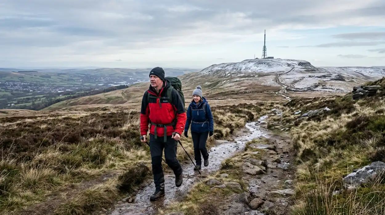
Access paths originate from Belmont in Blackburn with Darwen, Rivington in Chorley, and Horwich plus Blackrod in Bolton. A road pass 2 kilometers west of Belmont, allowing a short summit walk. These routes traverse open moorland, exposing hikers to variable weather patterns typical of upland Britain.
Where is Winter Hill located?
Winter Hill sits on the borders of Chorley, Blackburn with Darwen, and Bolton boroughs in Greater Manchester's northwest fringe, 5 kilometers northwest of Bolton town center. Coordinates place it at 53°37′48″N 2°30′54″W on Rivington Moor within the West Pennine Moors.
Bolton lies 16 kilometers northwest of Manchester city center. Winter Hill overlooks Bolton from the north, with Horwich at its southern base. The M61 motorway provides the main approach, exiting at junction 6 toward Horwich.
Rivington village anchors the eastern side, while Belmont village lies to the north. Blackrod borders the west. This positioning integrates Winter Hill into the West Pennine Moors, a 90-square-kilometer area of protected countryside managed by Lancashire County Council.
Proximity to urban centers drives its popularity. Manchester residents reach it in 35 minutes by car via the M61. Public transport includes buses from Bolton to Horwich, followed by a 3-kilometer walk to the trailheads.
Why is Winter Hill the highest point in Bolton?
Winter Hill's southeast slope reaches 447 meters above sea level, 400 meters southeast of the summit trig point, qualifying it as Bolton's highest elevation. The trig point at 456 meters marks Blackburn with Darwen's highest point, but Bolton's boundary places its peak on the adjacent slope.
Ordnance Survey defines heights using trig points, concrete pillars for surveying. Winter Hill's trig point (S6852) records 456 meters, but municipal boundaries determine borough maxima. Bolton's border crosses the slope 440 yards from the trig, capturing the 447-meter spot.
This distinction arises from administrative lines drawn in the 1974 local government reorganization. Prior, the area fell under Lancashire County Council. The hill's prominence ensures visibility from 50 kilometers on clear days, reinforcing its landmark status.
Comparisons highlight uniqueness. Nearby Pike Rivington reaches 363 meters. No other Bolton feature exceeds 447 meters, per Ordnance Survey data. This elevation supports diverse flora, including heather moorland adapted to acidic peat soils.
What is the history of Winter Hill?
Winter Hill features Victorian mass trespass in 1896, when 10,000 Bolton residents reclaimed a footpath blocked by landowner Colonel Henry Ainsworth over three weekends. The 1958 air disaster killed 35 when a Bristol 170 crashed in snow due to navigation error. Mining occurred historically on the moors.
In 1896, Colonel Ainsworth of Smithills Hall fenced grouse moors to exclude walkers. Bolton workers, seeking weekend escape from mills, dismantled gates on September 6, 13, and 20. Courts upheld the public right of way, predating the 1932 Kinder Scout trespass.
The Winter Hill air disaster struck February 27, 1958. Silver City Airways Flight G-AICS from Isle of Man to Manchester mistuned its radio compass to Oldham Beacon instead of Wigan amid snow. It struck 300 meters below the summit; seven survived. A memorial stands near the site.
Coal mining extracted peat and coal from Roman times through the 19th century. Remains include shafts near Horwich. The TV mast construction in 1961 boosted the local economy but altered the skyline permanently.
How do you get to Winter Hill from Bolton?
Drive northwest from Bolton center via A673 and Belmont Road for 5 kilometers to Lower House car park, a free lot off Sheep House Lane. Buses from Bolton to Horwich run every 30 minutes; walk 2 kilometers north. Manchester adds 35 minutes via M61 junction 6.
Bolton bus station offers TransPennine Express services to Horwich Parkway, then the 520 bus to Horwich center. From there, follow footpath signs north along Chorley Road. Cyclists use National Cycle Route 6, linking to trailheads in 20 minutes.
Car access follows A673 through Egerton to Belmont. Turn onto Sheep House Lane; parking holds 100 vehicles. Avoid weekends when full by 9 AM. Electric vehicle chargers operate at Horwich Lidl, 2 kilometers south.
Trains reach Blackrod station, 3 kilometers west; taxis cost £8. Walking from Bolton center spans 8 kilometers, taking 2 hours along urban paths merging into moorland tracks.
What are the best routes to the Winter Hill summit?
The direct route from Lower House car park climbs 2.5 kilometers northeast along a gravel track and moorland path, gaining 250 meters in 1.5 hours. Belmont Road offers a 4-kilometer loop via Pigeon Tower. Rivington Pike route totals 9 kilometers round trip with a 350-meter ascent.
Lower House starts at grid ref SD637146. Follow the track 600 meters to Pigeon Tower junction, turn left onto Belmont Road for 2 kilometers, then right through a kissing gate onto the moorland path to summit. This intermediate path suits good fitness.
From Two Lads car park, ascend via the "Two Lads" standing stones, ancient markers 1 kilometer south of the summit. Path steepens over peat hags; total 3 kilometers, 200-meter gain. Combine with Rivington Pike for 11.8 kilometers and 390 meters ascent.
Horwich path begins at MacRonald Recreation Ground, following Reservoir Road to moor edge. This 5-kilometer out-and-back gains 300 meters steadily. All paths use Ordnance Survey 1:25,000 Explorer 287 map.
Where to park for hiking Winter Hill?
Lower House car park at Belmont Road end off Sheep House Lane provides free parking for 100 cars near Horwich in Bolton borough. Two Lads car park charges £2 donation; Rivington Hall Barn offers free spots until 7 PM. Arrive before 9 AM weekends.
Lower House (SD637146) fills quickly; overflow uses roadside verges legally. No toilets available. Two Lads lot near the standing stones suits the southern approaches. Rivington options near cafes post-hike.
Disabled parking exists at higher points on Belmont Road, reducing ascent. Coaches park at Horwich leisure center, 1.5 kilometers south. National Trust manages some sites; check signage for restrictions.
What is the distance and difficulty of Winter Hill hikes?
Summit routes range 3-12 kilometers round trip with 200-400 meter elevation gain, rated intermediate. Direct from Lower House covers 5 kilometers in 2-3 hours; good fitness required for uneven peat paths and steep sections. Suitable ages 8+ with preparation.
Distance varies by start. Lower House to summit: 2.5 kilometers up, same return. Rivington Pike circular: 11.8 kilometers, 3.5 hours. Elevation profiles show steady 10% gradients, peaking at 20% near Two Lads.
Difficulty stems from the exposed moorland. Peat erosion creates boggy sections; stone flags aid drainage. Wind speeds average 20 km/h, gusting 50 km/h. 72 Komoot users rate paths easily accessible yet fitness-demanding.
What gear do you need to hike Winter Hill?
Pack waterproof jacket, fleece layers, sturdy boots, map, a compass, headtorch, snacks, and 1 liter of water per person. Add gaiters for peat, poles for stability, and a first aid kit. Winter requires crampons if icy; always carry a survival bag.
Base layer uses Merino wool for moisture wicking. Mid-layers insulate; shell blocks wind. Boots feature grippy soles for mud. Ordnance Survey OL287 map and compass navigate fog. Headtorch with spare batteries covers short days.
Navigation tools include GPS as backup. The group shelter protects from rain. Calorific snacks like nuts provide 500 calories. Flask holds a hot drink. Blizzard bag insulates in emergencies.
What is the weather like on Winter Hill?
Winter Hill experiences cool summers peaking at 23°C and cold winters averaging 2-7°C, with 1,200 mm annual rain and frequent fog. Winds average 15-25 km/h, gusting higher on the moors. Check Met Office forecasts; visibility drops below 100 meters often.
Bolton climate data shows January lows at 2°C, July highs 20°C. Moorland amplifies chill by 3°C. Annual rainfall totals 1,200 mm, peaking in October-March. Snow covers ground for 20 days yearly.
Mountain-Forecast records light rain 3-7 mm weekly. Fresh westerly winds dominate. Visibility impairs 40% of days. Drones monitor peat restoration, aiding weather pattern studies.
When is the best time to hike Winter Hill?
Spring (March-May) and autumn (September-November) offer mild 10-15°C temperatures, low crowds, and heather blooms. Avoid winter snow and summer peak weekends. Dawn hikes catch sunrise; check daylight hours averaging 8-16 daily.
March-May sees 12°C averages, dry paths post-winter. September-November brings 10°C with colorful foliage. Summer crowds peak on Saturdays; 10,000 annual visitors log via Komoot.
Daylight spans 16 hours June solstice, 8 hours in December. Sunrise hikes from Rivington Pike start 5 AM summer. The Met Office advises against dusk descents due to poor visibility.
What safety precautions should you take on Winter Hill?
Follow marked paths, inform someone of plans, carry a charged phone with OS Locate app, and turn back in poor visibility. Watch peat bogs and cliff edges; groups stay together. Emergency: call 999, quote OS grid SD661149.
Mountain Rescue operates from Horwich; response averages 45 minutes. Peat hags sink 0.5 meters; test ground ahead. Air disasters highlight fog risks; compass bearings prevent drift.
First aid covers blisters, hypothermia. Hypothermia sets in below 10°C with wind. A survival bag reflects 90% body heat. No mobile signal in valleys; summits connect reliably.
What views and landmarks can you see from Winter Hill summit?
Panoramas span Manchester, the Pennines, Lancashire plains, and the Irish Sea 50 kilometers distant on clear days. Spot Blackpool Tower, Scafell Pike, and Winter Hill TV mast up close. Pigeon Tower and Rivington Pike frame foreground.
The 360-degree vista covers 10,000 square kilometers. East: Manchester skyscrapers. North: Rossendale hills. West: coast. Mast at 305 meters towers above the trig point.
Landmarks include 19th-century Pigeon Tower reservoir. Air disaster memorial lies 300 meters downslope. Wild goats roam; curlew calls echo April-August.
Are there facilities or amenities near Winter Hill?
Horwich offers cafes, pubs, and supermarkets 2 kilometers south; Rivington cafes post-hike. No summit facilities; nearest toilets at car parks. Wild camping prohibited; Bolton Leisure Centre has showers.
Rivington Hall Barn cafe serves post-walk meals until 5 PM. Goose at Rivington pub stocks local ales. Wild camping bans stem from the Dartmoor ruling 2023; use designated sites.
Bolton Wanderers stadium lies 6 kilometers south. Recycling bins at trailheads. Dog bins frequent paths.
FAQS
What is Winter Hill?
Winter Hill is a 456-metre moorland summit on Rivington Moor, forming part of the West Pennine Moors and serving as the highest point for both Bolton (447 m) and Blackburn with Darwen (456 m).