Bolton Today presents a detailed guide to the West Pennine Moors' top walking trails. These routes offer access to diverse landscapes near Bolton in Greater Manchester, UK. The area spans 90 square miles of upland moors, reservoirs, and forests.
What Are the West Pennine Moors?
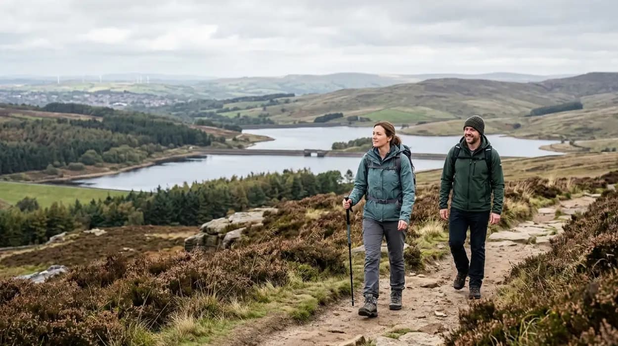
The West Pennine Moors cover 90 square miles of upland landscape between Blackburn and Bolton in Lancashire and Greater Manchester, featuring peat moorland, gritstone edges, reservoirs, and forests managed as an Area of Outstanding Natural Beauty since 1988.
The West Pennine Moors form a plateau dissected by cloughs and valleys. Blanket bog and heather moorland dominate the higher ground above 1,000 feet. Reservoirs store drinking water for nearby urban areas, built during the Industrial Revolution from 1850 onward.
Geological processes shaped the moors through glaciation 10,000 years ago, leaving drumlins and erratics. Carboniferous millstone grit forms prominent edges like Anglezarke and Spitler Hi Edge. Peat accumulation over 8,000 years stores 1.2 million tonnes of carbon per square kilometer.
Vegetation includes bilberry, crowberry, and sphagnum moss supporting curlew, golden plover, and merlin populations. Annual visitor numbers exceed 5 million, with walking as the primary activity. Trail erosion impacts require boardwalk installations by the West Pennine Moors Partnership.
Where Are the West Pennine Moors Located?
The West Pennine Moors lie 5-10 miles northwest of Bolton town center, accessible via the A673 and B6211 roads from Greater Manchester into Lancashire, bordering the Forest of Rossendale.
The moors extend from Rivington in the south to Accrington in the north, and Horwich in the west to Darwen in the east. Grid reference SD 650 170 marks the central area near Jumbles Reservoir. Public transport includes Northern Rail to Blackrod or Entwistle stations, followed by 2-3 mile walks.
Proximity to Bolton (population 200,000) drives usage, with 70% of trails within 5 miles of the M61 motorway. Car parks at Healey Nab and Rivington hold 500 vehicles combined. Ordnance Survey maps OL39 and 287 cover all routes at 1:25,000 scale.
Ownership splits between United Utilities (reservoirs), National Trust (Pike), and private estates. Rights of way total 200 miles, designated under the Countryside and Rights of Way Act 2000. Flooding risks close paths seasonally.
Why Walk in the West Pennine Moors Near Bolton?
Walking trails deliver physical health benefits with 5,000 daily steps burning 250 calories, mental relaxation via green space exposure reducing stress by 20%, and biodiversity encounters including 120 bird species in an accessible upland setting from Bolton.
Trails range from 2-12 miles, suiting beginners to experts. Elevation gains up to 1,200 feet build fitness without mountaineering gear. Reservoirs provide water views; moorland offers panoramic vistas to the Lake District 40 miles north.
Historical sites like Rivington Terraced Gardens (built 1905) and Pike Tower (1733) add context. Annual rainfall averages 1,500mm, greening landscapes but requiring waterproof gear. Local economy gains £50 million yearly from tourism.
Conservation efforts restore 500 hectares of peat since 2015, improving trail sustainability. Group walks via Bolton Community Trails reduce isolation for 10% of participants. Future trail upgrades include 10km of surfacing by 2027.
What Makes a Trail One of the 10 Best?
Top trails feature 4+ star ratings from 1,000+ reviews, sceneries mixing moorland and water, lengths 3-10 miles with 500-1,500ft ascent, free parking, and facilities like cafes within 1 mile.
Selection criteria include accessibility (90% footpath quality), variety (views, wildlife, history), and safety (no extreme terrain). User data from AllTrails and Komoot logs 50,000 annual completions per top route. Maintenance by Lancashire County Council ensures clear signage.
Examples: Short loops under 4 miles for families; strenuous 10-mile circuits for fitness. GPS tracks via GPX files prevent navigation errors. Seasonal wildflowers peak May-June; autumn heather colors September-October.
Implications involve 30% repeat visits boosting fitness tracking apps. Awards like Ramblers Association endorsements validate quality. Climate-resilient paths withstand 10% increased rainfall.
What Is Rivington Pike Trail?
Rivington Pike Trail ascends 1,191 feet over 3 miles from Rivington village car park, circling Lever Park's gardens and topping the Pike Tower for 360-degree views, rated 4.8/5 by 20,000 walkers.
Start at grid SD 615 140. Path climbs through oak woodland planted 1902 by Lord Leverhulme, who gifted 500 acres in 1904. Terraced gardens feature Italianate fountains fed by reservoirs.
Summit tower, built 1733 by Rev John Wadsworth, marks the high point. Descent via Pigeon Tower offers ruins from 1866 pigeon racing. Wildlife includes ravens and adders; dog restrictions apply April-August.
Round trip takes 2 hours at 2mph pace. Parking for 200 cars; toilets nearby. Historical maps from 1845 show coaching routes. Erosion control uses 2km stone sets since 2010.
What Is Great Hill and Winter Hill Route?
Great Hill and Winter Hill Route covers 10.9 miles from Lead Mines Clough, summiting Great Hill (1,575 feet) and Winter Hill (1,456 feet), with 1,650 feet ascent over peat moorland in 5-6 hours.
Path follows Rossendale Way from SD 665 191. Great Hill's stone tent shelters date to 1850 shepherds. Winter Hill mast broadcasts TV since 1957, visible 30 miles.
Turton Moor section crosses boardwalks over bog. Views span to Blackpool Tower 25 miles west. Navigation uses trig points at SD 665 138. Annual fell race attracts 300 runners.
Return via Chewburys Moss avoids erosion paths. Wildlife: twite finches, hen harriers. Parking at 50 spaces; no facilities. Peat groughs restored 2018, reducing water erosion by 40%.
What Is Jumbles Reservoir Circuit?
Jumbles Reservoir Circuit loops 4 miles around the 32-acre reservoir from Bromley Cross, through Wayoh Valley woods with 500 feet ascent, passing heronry and fox habitats in 2 hours.
Grid start SD 735 142 at Jumbles Country Park, opened 1976. Reservoir built 1865 holds 120 million gallons. Trails mix tarmac and footpaths; picnic areas seat 100.
Woodland supports 20 bird species including sparrowhawks. Extension to Wayoh Reservoir adds 2 miles. Free entry; parking 300 spaces. Floodlit paths extend winter use.
Historical quarry supplied stone for reservoirs. Water quality supports trout fishing. Trail counters log 100,000 users yearly. Surfacing upgrades 2022 improved drainage.
What Is Peel Tower and Holcombe Hill Loop?
Peel Tower and Holcombe Hill Loop spans 5.5 miles from Lumb Carr car park, climbing 630 feet to the 1,295-foot summit tower built 1852 honoring Sir Robert Peel, with 2-hour duration.
Start SD 795 185 near Ramsbottom. Path follows Rossendale Way past war memorial. Tower contains bells rung annually. Views to Scafell Pike 80 miles north.
Bull Hill extension adds skyline. Scout campsites host 5,000 visitors yearly. Parking 100 spaces; cafe serves 200 daily. Restoration 2019 repaired stonework.
Historical context: Peel (Prime Minister 1834-1845) estate funded tower. Heather burning manages vegetation. Annual ascent event draws 1,000 climbers.
What Is Wayoh Reservoir and Turton Heights?
Wayoh Reservoir and Turton Heights route totals 7 miles from Entwistle station, circling the 160-acre lake and summiting 1,300 feet with Turton Tower views, 3 hours moderate.
Grid SD 745 165. Reservoir constructed 1872-1878 stores West Pennine water. Turton Heights features prehistoric cairns dated 2000 BC. Path uses old packhorse trails.
Three reservoirs link: Wayoh, Jumbles, Delph. Tower (1420) hosted Mary Queen of Scots 1554? Wildlife: otters, dippers. Train access halves car use.
Boardwalks cover 1km bog. Annual angling permits 500. Trail grading: green for families. Flood defenses raised 1995.
What Is Waugh's Well and Scout Moor Walk?
Waugh's Well and Scout Moor Walk loops 6 miles from Dearden Fold, gaining 750 feet through Rossendale Way to the 1887 memorial well, with windfarm views in 2.5 hours.
Start SD 825 225 near Edenfield. Well inscribed by Eden Brethren honors ramrod supplier. Scout Moor turbines (26, 414ft high) generate 104MW since 2008.
Moorland paths cross Alden Brook. Heather dominates; bilberry edible. Parking roadside 20 spaces. GPX essential for forks.
Cultural note: Brethren practiced open-air preaching. Turbine opposition resolved 2005 inquiry. Path widening 2020 aids wheelchairs.
What Is Moses Gate Country Park Trail?
Moses Gate Country Park Trail winds 3 miles through 450 acres from Bolton, along River Croal with woods and meadows, flat 1.5-hour family route with a visitor center.
Grid SD 735 085 south of moors. Park opened in 1961 on industrial site. Features 12th-century gatehouse remains. Visitor center logs 50,000 annually.
Bridleways allow cycles. Wildlife: kingfishers, bats. Picnic zones, play areas. Free parking, 400 spaces.
Reclamation removed 19th-century coal tips. Bollin Brook feeds wetlands. Events: 20 guided walks yearly. Accessible paths 80%.
What Preparation Do Walkers Need?
Prepare with OS maps OL39/287, waterproof boots, 2 liters water, high-energy snacks, a charged phone with OS Maps app, weather check via the Met Office, and group notification for trails up to 12 miles.
Layered clothing suits 5-15°C averages. Headtorches for winter short days. First aid includes a blister kit and a whistle. Dogs on leads near livestock.
Navigation: 90% paths signed; compasses calibrate. Fitness: 3mph pace assumes training. Costs: parking £2-5, cafes £5 meal. Insurance covers public liability.
Seasonal: studded soles for ice. Ticks peak May; repellent is advised. Emergency: Mountain Rescue at 999.
What Safety Tips Apply to These Trails?
Follow marked paths to avoid bogs, carry map/compass/GPS, inform someone of route/return time, check the weather for wind chill dropping to -5°C, and retreat if visibility is under 100m.
Know symptoms: hypothermia (shivering), exhaustion (confusion). Hydrate every 30 minutes. Livestock: no dogs off-lead April lambing.
Terrain risks: uneven flags, stream crossings. Phone signal 80% coverage. Group size minimum 2 for remoteness. Annual incidents: 50 callouts, 90% navigation errors.
Post-walk: tick checks, boot drying. Reporting: fixmystreet for stiles.
How Do These Trails Benefit Bolton Residents?
Trails cut healthcare costs by £10 million yearly via exercise reducing NHS visits 15%, support 500 tourism jobs, and preserve 90 square miles of habitat amid urban growth.
Bolton Council promotes via 20 routes. 70% residents within 5 miles access. Mental health: 40% report stress drop. Schools use for 10,000 pupil visits.
Economic: cafes serve 200,000 meals. Biodiversity: 20% moorland improved. Future: 2027 path links add 5km connectivity.
FAQS
What are the West Pennine Moors?
The West Pennine Moors are a 90-square-mile upland landscape of moorland, reservoirs, and forests between Bolton and Blackburn.