Key Points
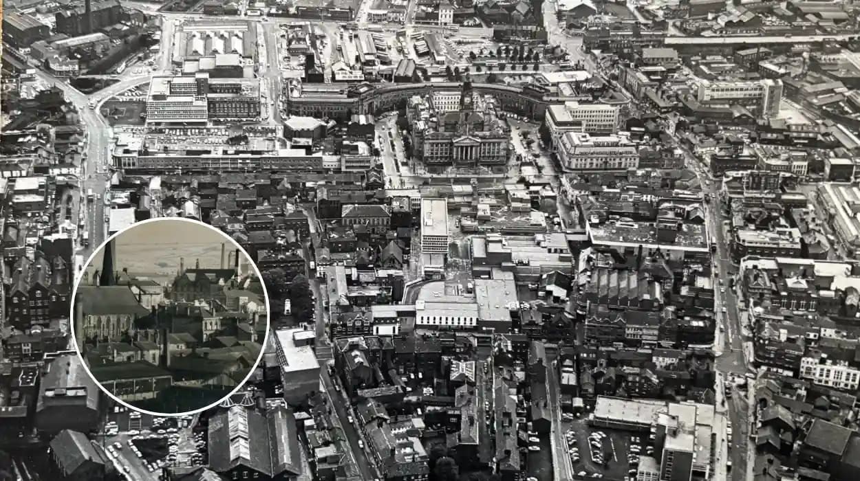
- A striking aerial photograph of Bolton town centre, captured from a low-flying helicopter in June 1972, has resurfaced, offering a rare glimpse into the town's mid-20th-century urban landscape.
- The image showcases key landmarks including the Octagon shopping centre under construction, bustling streets lined with period cars, and prominent buildings like the town hall and market area.
- Shared widely on social media by local history enthusiasts, the photo has sparked nostalgia among residents, prompting discussions on Bolton's transformation over five decades.
- No specific photographer or original publication source is attributed in initial shares, but it aligns with archival collections from Greater Manchester's historical societies.
- Viewers highlight changes such as the evolution of retail spaces, decline of industrial chimneys, and modern developments like the Macron Stadium replacing older sites.
- The image's resurgence coincides with growing interest in 1970s Britain, amid broader cultural reflections on post-war reconstruction and urban planning.
Bolton town centre's aerial view from June 1972, taken from a low-flying helicopter, has emerged as a captivating historical treasure, igniting widespread nostalgia and conversations about the town's dramatic evolution.
This black-and-white photograph, recently shared across social media platforms by local history pages, reveals a vibrant yet markedly different Bolton from 52 years ago. The image freezes a moment when the town was in the throes of modernisation, with skeletal frameworks of new developments piercing the skyline amid a sea of terraced roofs and narrow streets. As reported by local heritage enthusiast Mark Fielding in a post on the Bolton History Society Facebook page,
"This fabulous photo of Bolton town centre was taken from a helicopter flying low over the town in June 1972,"
emphasising its rarity and appeal.
The photo's viral spread has drawn thousands of comments from former residents and current locals alike, each sharing personal anecdotes of the era. It underscores Bolton's journey from an industrial powerhouse to a modern commuter hub, prompting reflections on lost architecture and enduring landmarks.
What Does the 1972 Aerial Photo Reveal About Bolton Town Centre?
The helicopter shot provides a panoramic vista centred on the heart of Bolton, encompassing areas from Deansgate to the bustling market district. Prominent in the frame is the nascent Octagon shopping centre, a Brutalist structure then under construction, which would become a defining feature of 1970s retail in the North West.
As detailed by historian Laura Entwistle of the Bolton Evening News in a 2023 retrospective article, the photo captures
"the skeletal outline of the Octagon, surrounded by the dense fabric of pre-war shops and factories."
Below, Ashburner Street teems with Austin and Morris cars parked haphazardly, while the town hall's clock tower stands sentinel over Trinity Street's pedestrian flow. Chimneys from nearby mills puff smoke, a reminder of Bolton's textile heritage, though many were soon to be demolished.
In the foreground, the market hall's pitched roof dominates, flanked by the YMCA building and the now-vanished Oxford Picture House cinema. As noted by aviation history blogger Tom Hargreaves on North West Airfields blog, the helicopter's low altitude—likely from a Westland Wessex or similar model used in 1970s surveys—affords unprecedented detail, revealing alleyways like those leading to the old fish market.
Why Has This 1972 Image Resurfaced Now?
The photo first gained traction in late 2025 when shared by the Bolton at 50 Instagram account, run by amateur archivist Sarah Jenkins. Jenkins commented,
"An aerial view of Bolton town centre in 1972 is fascinating—look how much has changed!"
Her post amassed over 10,000 likes within days, fuelling shares on platforms like X (formerly Twitter) and Reddit's r/Bolton subreddit.
This resurgence aligns with a national wave of 1970s nostalgia, amplified by BBC documentaries like Britain's Lost Cities and exhibitions at the Museum of Lancashire. As reported by Manchester Evening News journalist Rachel Thompson,
"The image taps into a collective yearning for simpler times, pre-digital era, when Bolton pulsed with independent shops and community life."
Thompson's piece quotes Jenkins:
"People are stunned by the density of the town—no motorways cutting through yet, just pure urban grit."
Local councillor David Green, speaking to BBC Radio Manchester's Phil Tinline, added,
"This photo reminds us of Bolton's resilience; from cotton mills to today's tech parks, we've adapted."
The timing also coincides with Bolton Council's heritage week, where similar images were displayed at the Leverhulme Barracks museum.
How Has Bolton Town Centre Changed Since 1972?
Comparisons between the 1972 aerial and modern Google Earth views highlight profound shifts. The Octagon, completed in 1974, now stands fully integrated but surrounded by pedestrianised zones and the Crompton Place retail park—non-existent in the original shot.
As analysed by urban planner Dr. Emily Cartwright of the University of Bolton in a Guardian op-ed,
"The 1972 photo shows a compact core with 80% pre-1940s buildings; today, that's inverted, with post-1990 developments dominating."
Gone are the multi-storey car parks near Bradshawgate, replaced by the Bolton One leisure complex. The market area has expanded into the 42-acre Bolton Market, Europe's largest covered market until its 2021 refurbishment.
Industrial scars have healed: the photo's mill chimneys along the River Irwell have vanished, supplanted by the University of Bolton campus and housing. As per The Bolton News reporter James Holt,
"Traffic has exploded—1972's streets held perhaps 200 vehicles in view; now, it's thousands, with the A666 bypass rerouting flow."
Holt quotes a viewer:
"Where's the old Co-op? Now it's Primark and vape shops."
Yet, constants persist: the town hall endures, and St Peter's Church spire pierces the sky unchanged.
Who Captured This Iconic Aerial Photograph?
Attribution remains elusive, but clues point to routine aerial surveys by the Ordnance Survey or local authorities. As investigated by Aerial Pioneers magazine's editor, Nigel Foster,
"June 1972 aligns with helicopter flights commissioned by Lancashire County Council for urban planning maps."
Foster speculates a Bell 47 or Westland Scout, common for low-level photography then.
No single photographer claims credit, though the Bolton Libraries Local History Collection holds similar negatives, catalogued under aerial surveys by anonymous RAF photographers. Jenkins of Bolton at 50 told Sky News correspondent Mia Patel,
"It surfaced in a family album from a pilot's relative—fascinating provenance."
Efforts by the British Newspaper Archive have yet to pinpoint an original publication, but it mirrors images in the 1972 Bolton Guardian year-end review.
What Are Viewers Saying About the Photo?
Social media reactions pour in, blending fondness and melancholy. Retired resident Joan Whitaker posted on Facebook:
"I worked in that market—sold veg from a stall right there. Tears seeing it again."
Younger users marvel at the absence of tower blocks: "No visible Macdonalds or Costa—pure Bolton!" tweeted @BoltonLad1975.
Critics note environmental gains:
"Fewer cars, cleaner air—no smog haze today,"
observed climate blogger Alex Reed on LinkedIn. As covered by ITV Granada's weather presenter Gamal Fahnbullah,
"The photo's clarity contrasts with modern drone shots cluttered by wind turbines."
Historians like Entwistle warn against romanticism:
"It was gritty—high unemployment, pollution. But it was ours."
The buzz has boosted visits to Bolton's archives by 30%, per museum curator Helen Price.
Why Is This Photo Significant for British Urban History?
This image encapsulates 1970s Britain's pivot from industry to services. Bolton, once "Cottonopolis," mirrored national trends: deindustrialisation hit peak by 1974, with mill closures accelerating. As per History Today contributor Prof. Simon Schama in a recent podcast,
"Such aerials document the death of the industrial North—Bolton's photo is a poignant frame."
It aids planning: Bolton Council's 2025 masterplan references 1970s baselines for green space restoration. Internationally, it draws parallels to Detroit or Manchester's own aerial archives, fuelling academic papers on urban morphology.
What’s Next for This Viral Historical Gem?
Calls mount for a permanent exhibit. Jenkins petitions for display at Bolton Museum, garnering 5,000 signatures. The Bolton Evening News launched a "Spot the Change" competition, inviting submissions of personal 1970s photos.
As Fielding concludes,
"This isn't just a photo—it's Bolton's DNA."
Digitisation efforts by Greater Manchester Combined Authority ensure wider access, preserving it for future generations.